RED IVES CABIN, ID Campground Reservation, Info, Images, Map, Directions

RED IVES CABIN, Idaho Campground Images, Info & Reservations

Listen

Directions

From St. Maries, Idaho: Follow paved Forest Highway 50 (St. Joe River Rd) 47 miles to Avery. Continue 29 more miles along FH-50 to the Red Ives Road #218. Turn right (south) on road #218 and travel 10 miles upstream to the Red Ives Ranger Station. The Red Ives Road is a narrow One-lane road with turn-outs.

Phone

(208) 245-2531

Activities

BIKING, CAMPING, FISHING, HIKING

Keywords

Related Link(s)

Rec Area Info & Images

Idaho State Road Conditions

Idaho State Tourism

Overview

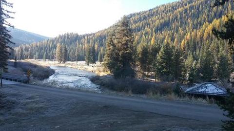
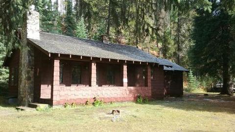
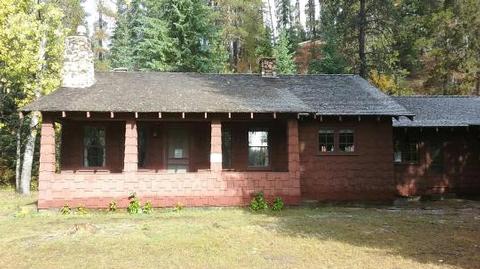
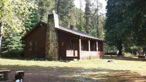
Red Ives Cabin is a popular location in the Idaho Panhandle National Forests. It served as the Ranger Station for the Red Ives Ranger District of the St. Joe National Forest from the 1930s to 1984. Attractions include its location on the St. Joe Wild and Scenic River. It is located 86 miles southeast of St. Maries, Idaho on Forest Road 218.  

The Cabin requires an entry key code to get in. Contact St. Joe Ranger District for instructions if you have a reservation at 208 245 2531.

Recreation

Red Ives offers several recreation opportunities from hiking and OHV use to world-class fishing and wildlife spotting. The St. Joe River also offers opportunities in floating and kayaking.

Facilities

The cabin features two bedrooms (one queen, two sets of bunkbeds and one queen size futon), kitchen, living room, bathroom and covered front porch; propane stove/oven and refrigerator; hot water, flush toilet and shower/tub. Battery lanterns are provided for lights, however visitors are recommended to bring additional battery operated lights. A gas log fireplace provides heat. Absolutely no pets.

Natural Features

The facility is set alongside the St. Joe National Wild and Scenic River. The terrain is mountainous with steep drainages and heavily forested mountain sides.

Nearby Attractions

Avery is the nearest town for conveniences.

Reservation

More from CampingHiking.net:

HASTINGS CAMPGROUND, Maine Campground Images, Info & Reservations

Listen Directions From Gilead, Maine, take Highway 113 south for 3 miles to campground. Phone 603-466-2713 Activities BIKING, CAMPING, FISHING, HIKING Keywords HAST,WHITE MOUNTAIN NF -FS Related Link(s) Rec Area Info & Images Maine State Road Conditions Forest Service Concessionaire Maine State Tourism Overview Hastings Campground is located on Route

PIEDMONT PARK, Missouri Campground Images, Info & Reservations

Listen Directions From Piedmont, MO, follow Missouri State Highway HH. Travel on Highway HH for 6 miles to the top of the dam. Turn right and follow signs into campground. Phone 573-223-7777 (CLEARWATER LAKE PROJECT OFFICE) 573-223-4432 (PIEDMONT PARK GATE HOUSE) Activities BOATING, CAMPING, SWIMMING SITE Keywords PIED,CLEARWATER LAKE,PIEDMONT,PARK ABOVE

PINNACLES CAMPGROUND, California Campground Images, Info & Reservations

Listen Directions Pinnacles National Park is located 32 miles south of Hollister, CA on Hwy 25 and 29 miles northeast of King City, CA on Hwy 25. Campground is located on the east side of Pinnacles National Park off Hwy 25. Phone 831-200-1722 OR GO TO WWW.VISITPINNACLES.COM Activities CLIMBING, CAMPING,

Soda Springs Campground, Washington Campground Images, Info & Reservations

Listen Directions Take Highway 410 to milepost 88.4, then turn left on Bumping Lake Road and continue for 5 miles to the campground. Phone 541-338-7869 Activities CAMPING, FISHING, HIKING, WATER SPORTS Keywords SOSP,Bumping River,OKANOGAN – WENATCHEE NF -FS Related Link(s) Rec Area Info & Images Washington State Tourism Washington State