BICENTENNIAL CAMPGROUND, CA Campground Reservation, Info, Images, Map, Directions

BICENTENNIAL CAMPGROUND, California Campground Images, Info & Reservations

Listen

Directions

Upon entering the Marin Headlands follow the signs to the Visitor Center. The campground is less than 1/2 mile drive from the Visitor Center.

Phone

415-331-1540

Activities

BIKING, HISTORIC & CULTURAL SITE, CAMPING, INTERPRETIVE PROGRAMS, VISITOR CENTER, MOUNTAIN BIKING, BERRY PICKING

Keywords

Related Link(s)

Rec Area Info & Images

California State Tourism

California State Road Conditions

Overview

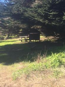
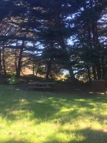
Bicentennial Campground is in an ideal location in the Marin Headlands surrounded by a grove of cypress trees. The campground is a great location for those wanting to camp near the city. There is a moderate short hill to climb to/from the campground from the parking area. It is downhill to the site and uphill back to the parking area. 

Recreation

The Marin Headlands is noted for its great hiking. Many trails exploring the entire area are close by. Rodeo Beach is about 1.5 miles away. Point Bonita Lighthouse and the historic Nike Site are within walking distance.

Facilities

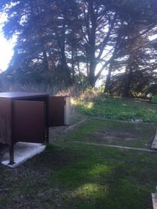
Bicentennial Campground has three campsites each accommodating up to three guests. Barbecue grills, food lockers and picnic tables are provided. The campground has a portable restroom on site and a pit toilet nearby.

Natural Features

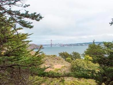
The campground is secluded amongst a cypress tree grove and offers great views of the Golden Gate Bridge and city of San Francisco.

Nearby Attractions

Bicentennial Campground is a short walk from the Point Bonita Lighthouse and the Nike Missile Site. Also close by are some of the many coastal defense gun batteries, the Marin Headlands Visitor Center, and the city of San Francisco.

Charges & Cancellations

For cancellations with less than 24 hours’ notice, no fees will be refunded.

Reservation

More from CampingHiking.net:

Trapper Creek Campground, Oregon Campground Images, Info & Reservations

Listen Directions From I-5 take exit 188A, heading west on Highway 58 for 62.4 miles, then continue 1.9 miles south on Road 5810 to the campground. Phone 541-323-1746 Activities BIKING, BOATING, CAMPING, FISHING, HIKING, WATER SPORTS, SWIMMING SITE Keywords TRPC,Trapper,Trap,Shelter Cove,Odell,Trapper Creek,Trapper Creek Campground Related Link(s) Rec Area Info &

PRAIRIE CREEK (AL), Alabama Campground Images, Info & Reservations

Listen Directions From Montgomery, Alabama, follow Highway 80 west for approximately 25 miles. Turn right on County Road 29 and follow the signs into the campground. Phone 334-418-4919 Activities BIKING, BOATING, CAMPING, FISHING, HIKING, WATER SPORTS, WILDLIFE VIEWING, SWIMMING SITE Keywords PRA1,JONES BLUFF,ALABAMA RIVERS,WOODRUFF,ROBERT F. HENRY,ROBERT F HENRY,ALABAMA RIV. –

PICNIC POINT (WI), Wisconsin Campground Images, Info & Reservations

Listen Directions From Medford, take State Highway 13 north 4 miles. Turn left (west) onto County Highway M for about 7 miles. Turn right (north) onto County Highway E and continue for about 8 miles. Turn right (east) onto Forest Road 1563 and continue for 1 mile, then turn right

FOX CREEK GROUP CAMP, Oregon Campground Images, Info & Reservations

Listen Directions From Detroit, Oregon, drive east on State Highway 22. After crossing the bridge, take a left onto Forest Service Road (FSR) 46/Breitenbush. Follow FSR 46 for about 6.5 miles to Fox Creek Group Camp. Phone 503-854-3366 Activities CAMPING, FISHING, SWIMMING SITE Keywords Fox Creek,Fox Creek Group,Fox Creek Camp,FCGC,Fox

FOX CREEK CABIN (MT), Montana Campground Images, Info & Reservations

Listen Directions There is no motorized access to this cabin. There are two travel options to Fox Creek Cabin: 1. South Cottonwood Trailhead. From Bozeman, MT: Drive south on S. Cottonwood Road for about 7 1/2 miles. Turn left onto Cottonwood Canyon Road and drive about 2.1 miles to the