ROCK CREEK CAMPGROUND, Oregon Campground Reservation, Info, Images, Map, Directions

ROCK CREEK CAMPGROUND, Oregon Campground Images, Info & Reservations

Directions

From Bend, travel about 50 miles southwest on Cascade Lakes Hwy (46). Campground is on left-hand side of Cascade Lakes Highway.

Phone

541-323-1746

Activities

CAMPING

Keywords

Related Link(s)

Rec Area Info & Images

Oregon State Tourism

Oregon State Road Conditions

Overview

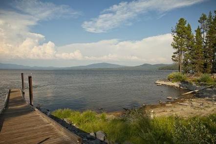
Rock Creek Campground is located on the western shore of Crane Prairie Reservoir along the Cascade Lakes Highway.  

Recreation

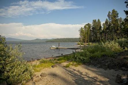
Crane Prairie Reservoir is known for fishing and boating opportunities. The Oregon Department of Fish and Wildlife manages populations of rainbow trout, mountain whitefish, brook trout and largemouth bass. Fish cleaning stations and a boat ramp are within the campground.

Facilities

Located just off the Cascade Lakes Highway, Rock Creek Campground is spread out along the western shores of Crane Prairie Reservoir. Almost all the sites are large and isolated from the other sites, and many are located right on the shore of the lake. 

This facility has a boat ramp offering access to Crane Prairie Reservoir. Boat launch parking is for day use only and requires a recreation fee separate from camping fees.

Natural Features

Crane Prairie Reservoir is a great spot for viewing a variety of wildlife. Sandhill cranes, bald eagles and osprey frequent the area. The adjacent forest is home to black-backed woodpecker, Williamson’s sapsucker and mountain chickadee.

On summer mornings or evenings, visitors may glimpse Rocky Mountain elk grazing the lakeside meadows. Deer, squirrel, beaver and an occasional black bear also find habitat in the surrounding forest.

Nearby Attractions

Nearby Osprey Point is a unique interpretive area where visitors can observe osprey nesting platforms erected after natural snags toppled from age.

Visitors enjoy traveling the Cascade Lakes Scenic Byway which climbs 66-miles through the Cascade Range, weaving past snow-capped peaks and alpine lakes.

Reservation

More from CampingHiking.net:

PETTIT BAY, Oklahoma Campground Images, Info & Reservations

Directions From Tahlequah, OK, go 8.25 miles south on Highway 82, turn right on Indian Road and go two miles south. Then turn left and go one mile southeast on the paved access road. Phone 918-487-5252 Activities BOATING, CAMPING, SWIMMING SITE Keywords PETT,TENKILLER LAKE,TENKILLER FERRY LAKE,TENKILLER FERRY Related Link(s) Rec

JUNIPER CAMPGROUND, New Mexico Campground Images, Info & Reservations

Directions From Santa Fe, take Saint Francis Drive (Highway 84/285) north toward Los Alamos. After passing Pojoaque, merge right onto New Mexico 502 to Los Alamos. Continue up 502 toward Los Alamos. Bear right and exit onto New Mexico 4 toward White Rock. Continue for 12 miles, passing White Rock.

BLANDING LANDING, Illinois Campground Images, Info & Reservations

Directions 13 miles south of Galena, IL off HWY 20, turn west on Blackjack and follow directional signs. DO NOT TAKE DIGGIN HILL RD. Phone RANGER STATION: 563-582-0881 / CAMPGROUND ENTRANCE STATION: 815-591-2326 (5-8 PM DAILY) Activities CAMPING, FISHING, PICNICKING, WILDLIFE VIEWING, DAY USE AREA, BIRDING, WATER ACCESS Keywords BLAN,MISSISSIPPI

WRIGHTS LAKE, California Campground Images, Info & Reservations

Directions Take Highway 50 east of Placerville, California, for 11 miles. Turn left onto Ice House Road and continue for 9 miles, then turn right onto Wrights Lake tie road. After 2 miles, turn left onto Wrights Lake Road. Phone 831-245-6891 Activities CAMPING, FISHING, HIKING, DAY USE AREA, SWIMMING SITE,

HUNGRY GULCH, California Campground Images, Info & Reservations

Directions From Bakersfield take Highway 178, to the town of Lake Isabella. From Lake Isabella, take Highway 155 North approximately four miles to the campground. Phone 760-376-1815 Activities CAMPING Keywords HUNG,LAKE ISABELLA,KERN VALLEY,SEQUOIA NF – FS Related Link(s) Rec Area Info & Images California State Road Conditions California State Tourism