AUK RECREATION AREA SHELTER 5, AK Campground Reservation, Info, Images, Map, Directions

AUK RECREATION AREA SHELTER 5, Alaska Campground Images, Info & Reservations

Listen

Directions

From the cruise ship terminal on South Franklin Street in downtown Juneau, head northwest along the waterfront. South Franklin Street becomes Marine Way, then Egan Drive, named for William A. Egan (1914 – 1984), first governor of the State of Alaska. Egan Drive becomes Glacier Highway at Milepost 9.4, then Juneau Veterans Memorial Highway from Milepost 12.1. About 14 mile exit west on Old Glacier Highway which brings you to Auke Village Recreation Area. The shelter is last one on the northwest end. Shelter number 5.

Phone

(907)586-8800

Activities

BOATING, CAMPING, FISHING, HIKING, VISITOR CENTER

Keywords

Related Link(s)

Rec Area Info & Images

Alaska State Road Conditions

Alaska State Tourism

Overview

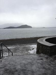
The Picnic Shelter #5 is part of the Auk Recreation Area and is located adjacent to a scenic beach on the northern shoreline of Auk Bay, once a village site for the Auk Tlingit Natives. It is the last shelter on the west end of the picnic area. It is the largest of the five shelters in the recreation area.

Recreation

The area offers fishing, water activities, picnicking, hiking, and berry picking.

Auk Recreation Area includes a large day use area on the shores of Auk Bay. The area includes five different shelters, picnic tables, drinking water, fire rings and a trail. At the Auk Bay Harbor commercial operators offer sport fishing, kayak rental, and whale watching tours.

Facilities

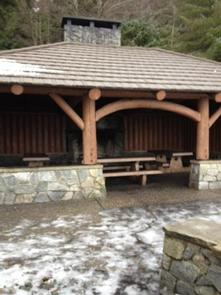
Shelter #5 has a maximum capacity of 40 people. The maximum group size allowed with this reservation is 74 people. Parking can be limited on sunny days due to crowds and is available above the shelter next to the highway (use caution loading and unloading). The shelter is accessed by a metal staircase or a fully accessible ramp. There are three picnic tables inside the shelter and a fire place. There are two grills next to the shelter, and a fire pit on the beach. There is a two-hole vault toilet a couple hundred feet from the shelter, and water spigot with city water on site. The path in front of the shelter leads to Auk Village Campground and Pt. Louisa. The opposite way leads to the restroom and another shelter.

Natural Features

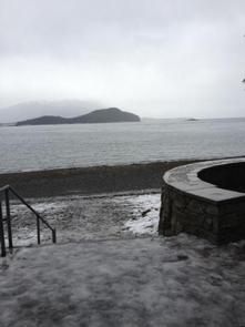
The shelter overlooks Auk Bay and is surrounded by a western hemlock and Sitka spruce forested area.

Reservation

More from CampingHiking.net:

BISHOP PARK GROUP, California Campground Images, Info & Reservations

Listen Directions From Highway 395 in the center of Bishop, turn west on Line Street (Highway 168) west and drive 15 miles to the campground on the left. Phone 760-935-4339 Activities CAMPING, FISHING, HIKING, HORSEBACK RIDING, WILDLIFE VIEWING Keywords BISH,INYO NF – FS Related Link(s) Rec Area Info & Images

CANYON VIEW GROUP SITES, California Campground Images, Info & Reservations

Listen Directions From Fresno, CA follow California State Highway 180 East, to its end. Canyon View Campground is on the left (north) side of the road. Phone 559-565-3341 Activities BIKING, CAMPING, HIKING, HORSEBACK RIDING, VISITOR CENTER Keywords Related Link(s) Rec Area Info & Images California State Tourism National Park Services

GUT ISLAND 2 CABIN, Alaska Campground Images, Info & Reservations

Listen Directions The Gut Island Cabins are located on Gut Island, adjacent to the western tip of Farm Island on the Stikine River delta in the Stikine-LeConte Wilderness. The cabin is 12 miles by float plane or shallow draft boat from Wrangell, or 7 miles from the boat ramp on

ALTURAS LAKE PICNIC AREA (ID), Idaho Campground Images, Info & Reservations

Listen Directions From Stanley, Idaho, take State Highway 75 south for about 22 miles. Turn right on Alturas Creek Road/Forest Road 205 and continue west for about 2.6 miles to the campground. Phone 928-537-8888 Activities BOATING, CAMPING, FISHING, HIKING, WATER SPORTS, SWIMMING SITE Keywords ALTU,SAWTOOTH NF – FS Related Link(s)

FLETCHER VIEW, Nevada Campground Images, Info & Reservations

Listen Directions From Las Vegas, Nevada, travel north on Highway 95 to the junction with Highway 157/Kyle Canyon. Turn left and travel approximately 18 miles; campground is on the left side of the highway. Phone 702-872-5486 Activities BIKING, CAMPING, HIKING, WILDLIFE VIEWING Keywords FLET,MOUNT CHARLESTON,LAS VEGAS,SRING MTNS NATIONAL REC AREA,HUMBOLDT-TOIYABE

MALDEN LAKE CAMPGROUND, Texas Campground Images, Info & Reservations

Listen Directions From I-30, exit onto Highway 8 at New Boston, Texas. Take Highway 8 south through Maud. Approximately six miles south of Maud, the park road will be on the left. Phone 903-585-2497 Activities BIKING, BOATING, CAMPING, FISHING, HUNTING, WILDLIFE VIEWING Keywords MALD,HERRON CREEK,WRIGHT PATMAN LAKE,HWY 8 PARK,WRIGHT PATMAN