HASTINGS CAMPGROUND, ME Campground Reservation, Info, Images, Map, Directions

HASTINGS CAMPGROUND, Maine Campground Images, Info & Reservations

Listen

Directions

From Gilead, Maine, take Highway 113 south for 3 miles to campground.

Phone

603-466-2713

Activities

BIKING, CAMPING, FISHING, HIKING

Keywords

HAST,WHITE MOUNTAIN NF -FS

Related Link(s)

Rec Area Info & Images

Maine State Road Conditions

Forest Service Concessionaire

Maine State Tourism

Overview

Hastings Campground is located on Route 113 near the shore of Evans Brook in western Maine. It is situated in a rustic and remote part of White Mountain National Forest, not far from the towns of Gilead Me and Gorham, New Hampshire. Activities include fishing, hiking and mountain biking. The White Mountains boast pristine forests, clear mountain streams and rivers and the tallest peaks in the Northeast. The forest encompasses nearly 800,000 acres in New Hampshire and western Maine, and is one of the most popular in the country.

Recreation

Within a short drive, campers can access numerous hiking trails of various levels, including a short, 2-mile trail that is great for families, as well as a more rigorous 9-mile trail on Mt. Hastings.

Fishing is available in nearby streams and rivers, and the famous Appalachian Trail is about a half-hour drive from the campground.

The area also hosts four alpine and five Nordic ski areas, which provide year-round recreation opportunities such as skiing, hiking, mountain biking, outdoor concerts, interpretive trails, special events and regional and national skiing and snowboarding races.

Learn more about recreation in the national forest.

Facilities

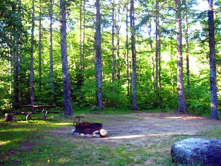
Campsites are shaded and well-separated around a single loop. Accessible restrooms and a hand pump for water are provided within the facility. The campground also has a large, open play area for kids.

Natural Features

The campground sits in a mixed hardwood forest at the base of Mt. Hastings and a short distance from Evans Brook and the Wild River. The forest is home to many species of northern wildlife, including moose, white-tailed deer and black bear. Almost 200 species of birds, including the rare Bicknell’s Thrush, live in the White Mountains.

Nearby Attractions

Campers enjoy a scenic day trip to the Presidential Range, which consists of the tallest mountains in the forest, including the 6,288-foot Mount Washington, the highest peak north of the Smoky Mountains and east of the Mississippi River.

Reservation

More from CampingHiking.net:

ALTAMONT, Utah Campground Images, Info & Reservations

Listen Directions From Salt Lake City, Utah, travel south on I-15 to Alpine-Highland exit 284. Travel east on Highway 92 approximately 13 miles through American Fork Canyon, then 3 miles south on the Alpine Loop Scenic Byway. Campground is on the left. Phone PLEASANT GROVE RANGER DISTRICT 801-785-3563 OR UTAH

APACHE MAID CABIN, Arizona Campground Images, Info & Reservations

Listen Directions From Phoenix, travel north on Interstate 17 to exit 306 (Stoneman Lake Road/Forest Road 213). Go east on Stoneman Lake Road for approximately 6.5 miles, to the junction with Forest Road 229. Turn right onto Forest Road 229 and go 4.5 miles to Forest Road 230. Veer right,

WHITE RIVER, California Campground Images, Info & Reservations

Listen Directions From Highway 99, turn east onto J22. Proceed on J22 through California Hot Springs to the "T" intersection. Turn right at intersection M56 through Pineflat. Go 3 miles on the gravel road and turn directly across the bridge. The entrance is a quarter-mile past the bridge on the

MIDDLE MEADOWS, California Campground Images, Info & Reservations

Listen Directions From Sacramento, California, take Interstate 80 east to Auburn. Take the Elm Street exit and turn left at the stoplight. Follow Highway 49 down the canyon, across the American River, to Cool. Turn onto Highway 193 towards Georgetown. Turn left at the stop sign, then continue 22 miles

LOWER LITTLE TRUCKEE, California Campground Images, Info & Reservations

Listen Directions From either east bound or west bound Interstate 80 in Truckee take exit 188, Highway 89 north to Sierraville. In aproximately 11 miles turn left into the campground. Phone (530) 994-3401 Activities CAMPING, FISHING, HIKING, HUNTING, MOUNTAIN BIKING, SCENIC DRIVE Keywords LOLI,TAHOE NF – FS Related Link(s) Rec

DENBY POINT, Arkansas Campground Images, Info & Reservations

Listen Directions From Hot Springs, Arkansas, take US 270 west about 26.5 miles to Ouachita Shores Parkway. Turn right and follow access road one mile north to park. From Mount Ida, Arkansas, take US 270 east approximately 9.5 miles to Ouachita Shores Parkway. Turn left on access road one mile