BLACK OAK, CA Campground Reservation, Info, Images, Map, Directions

BLACK OAK, California Campground Images, Info & Reservations

Directions

From Georgetown, head northeast on Main Street/Wentworth Springs Roadd toward Orleans Street. Continue to follow Wentworth Springs Road for 17 miles and cross the dam at Stumpy Meadows Lake. Continue 1 mile to the campground.

Phone

831-245-6891

Activities

BOATING, CAMPING, FISHING, HIKING, SWIMMING SITE, KAYAKING, CANOEING

Keywords

BOSM,ELDORADO NF – FS

Related Link(s)

Rec Area Info & Images

California State Tourism

Forest Service Concessionaire

California State Road Conditions

Overview

Black Oak Campground is group camping destination near Stumpy Meadows Lake on the Eldorado National Forest. The forest boasts over 400 miles of hiking trails and an abundance of lakes and rivers for fishing and swimming.

Recreation

Stumpy Meadows Lake, with its clear waters and 5-mph speed limit, offers plenty of swimming, kayaking and canoeing opportunities. The lake is regularly stocked with rainbow trout from May to August. Campers also enjoy birding and picnicking.

Facilities

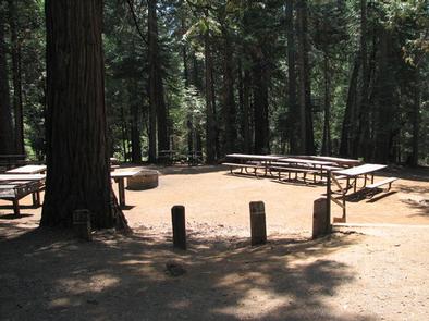
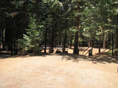
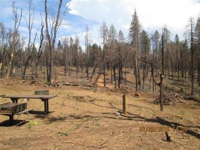
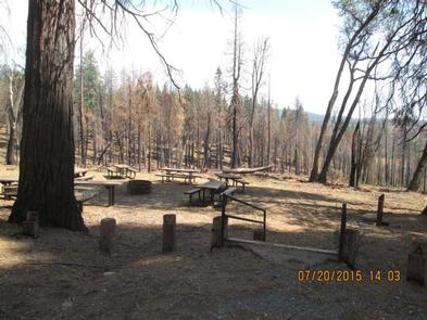
The group campground offers one RV site and three tent-only sites. The RV site accommodates up to 75 people, while the tent sites accommodate groups of 25 or 50. Each site is equipped with picnic and serving tables, grills and a campfire circle. Vault toilets are provided. A dump station is located on-site.

Natural Features

Black Oak sits at an elevation of 4,400 feet, within walking distance of the lake in the foothills of the rugged Sierra Nevada Range in California.

In the Eldorado National Forest, the climate is similar to that of the Mediterranean, with warm, dry summers and cold, wet winters.

Nearby Attractions

The El Dorado County Scenic Byway offers miles of scenic driving.

Reservation

More from CampingHiking.net:

Big Bend Group Sites, Utah Campground Images, Info & Reservations

Directions From Moab, drive north to the junction with Highway 128. Turn right and travel 8 miles along the river road. Group sites A and B are in the main campground, site C is up the dirt road directly across from the main campground. Phone 435-259-2100 Activities AUTO TOURING, BIKING,

KENT SPRINGS CABIN, Arizona Campground Images, Info & Reservations

Directions From the intersection of I-10 and I-19 in Tucson, travel south on 1-19 about 35 miles to the Continental Road exit (Exit 63) in Green Valley, Arizona. Turn left (east) onto Continental Road and go approximately 1 mile to the junction with the Madera Canyon/White House Canyon Road. Turn

BULL TROUT, Idaho Campground Images, Info & Reservations

Directions From Boise, Idaho, take State Street to Highway 55 north. At Banks, take Highway 17/Banks-Lowman Highway to Lowman. Take Highway 21 east to milepost 107. Turn left on Forest Road 520. Proceed on dirt road 2 miles to the campground. Phone 208-259-3361 Activities BIKING, BOATING, HISTORIC & CULTURAL SITE,

Dunewood Campground, Indiana Campground Images, Info & Reservations

Directions Please use this link to get to the directions page on our website. https://www.nps.gov/indu/planyourvisit/directions.htm Phone 219-395-1882 Activities BIKING, BOATING, CAMPING, INTERPRETIVE PROGRAMS, FISHING, HIKING, PICNICKING, VISITOR CENTER, WILDLIFE VIEWING, SWIMMING SITE, INFORMATION SITE, ENVIRONMENTAL EDUCATION, PHOTOGRAPHY, SWIMMING, KAYAKING, CANOEING, BEACHCOMBING, BIRDING, WATER ACCESS, EVENING PROGRAMS, GUIDED INTERPRETIVE WALKS, RECREATION

CURRANT CREEK, Utah Campground Images, Info & Reservations

Directions From Heber City, Utah, take Highway 40 east for 45 miles to the Currant Creek Junction. Turn off the highway and travel in a northwest direction approximately 17 miles to the campground. The road from the highway is paved for 10 miles and graded gravel for 7 miles. Stay