GREEN CREEK GROUP, CA Campground Reservation, Info, Images, Map, Directions

GREEN CREEK GROUP, California Campground Images, Info & Reservations

Directions

From Bridgeport, California, take Highway 395 south 5 miles. Turn west on Forest Road 142 and follow signs for 7 miles to the campground.

Phone

760-932-7092

Activities

CAMPING, FISHING, HIKING

Keywords

GREC,HUMBOLDT-TOIYABE NF-FS

Related Link(s)

Rec Area Info & Images

California State Tourism

Forest Service Concessionaire

California State Road Conditions

Overview

Green Creek Group Campground is located about 12 miles from Bridgeport, California, at an elevation of 7,500 feet. Visitors enjoy fishing on Green Creek and hiking the Green Creek Trail.

Recreation

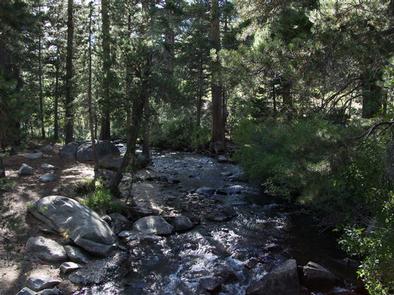
Green Creek offers rainbow trout fishing and can be easily accessed from within the campground.

Green Creek Trail, for hiking and horseback riding, can be accessed just outside the campground entrance. It leads to Green Lake and further on to East Lake. Rugged peaks surround both large lakes, where hikers are rewarded with good backcountry fishing and spectacular scenery.

Facilities

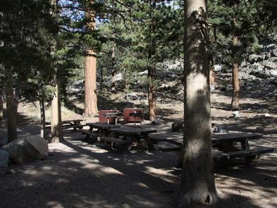
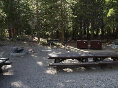
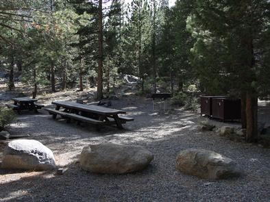
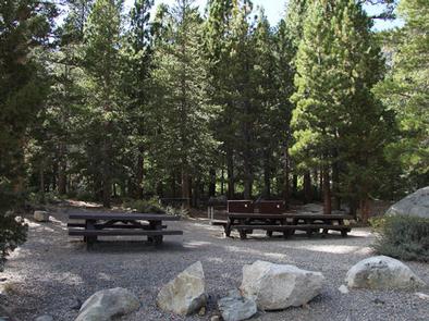
This primitive campground contains two group sites that can accommodate 25 and 30 people, with large picnic tables, campfire circles, grills and food storage lockers. Vault toilets and trash collection are provided. Roads and parking spurs are dirt.

Natural Features

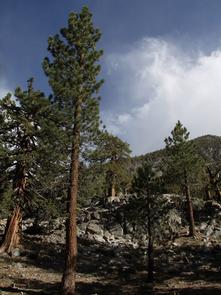
The campground is tucked between Green Creek and a rocky outcropping, among a forest of towering Jeffrey pines, which offer partial shade. Aspens, juniper, sagebrush and summer wildflowers dot the landscape.

Reservation

More from CampingHiking.net:

DOUGLAS CREEK CABIN, Montana Campground Images, Info & Reservations

Directions From Hall, travel south on Highway 1 for about 3 miles to Douglas Creek. Take Forest Road 707 and continue approximately 7 miles to the cabin. Maps may be purchased by calling the Pintler Ranger District. Phone 406-859-3211 Activities BIKING, CAMPING, HIKING, HUNTING, WINTER SPORTS, WILDLIFE VIEWING Keywords DCAB,BEAVERHEAD-DEERLODGE

PLATTER FLATS, Texas Campground Images, Info & Reservations

Directions From Colbert, Oklahoma, travel 5 miles north on US 75, turn west 5 miles to Platter Flats, OK, then follow signs to the campground. Physical address: 867 Trail Ride Road, Platter, OK 74753. Phone 580-434-5864 Activities CAMPING Keywords PLAT,TEXOMA LAKE,TEXOMA LAKE Related Link(s) Rec Area Info & Images Oklahoma

JOHN F KENNEDY, Arkansas Campground Images, Info & Reservations

Directions From Heber Springs, AR, take SR-25 north 4 miles, cross the dam, and turn right on the second road. Phone 501-250-0481 Activities CAMPING, WILDLIFE VIEWING Keywords JOHN,JFK,GREERS FERRY LAKE,GREERS FERRY LAKE Related Link(s) Rec Area Info & Images Arkansas State Tourism Arkansas State Road Conditions Overview John F. Kennedy

RIVERSIDE CAMPGROUND, Oregon Campground Images, Info & Reservations

Directions From Sisters, OR: Travel 9.6 miles northwest on Highway 20, then 4.4 miles north on Forest Road 14. Phone 541-323-1746 Activities CAMPING Keywords Related Link(s) Rec Area Info & Images Oregon State Tourism Oregon State Road Conditions Overview Located on the upper Metolius River, Riverside Campground is one of

LITTLE CRATER LAKE, Oregon Campground Images, Info & Reservations

Directions From Sandy, travel east on Highway 26 for approximately 40 miles to Skyline Road (Road 42). Turn right and travel south for 4 miles. Turn right on Forest Road 58 and travel 2 miles to the campground. Phone 503-630-5721 Activities HISTORIC & CULTURAL SITE, CAMPING, FISHING, HIKING, WILDLIFE VIEWING

WAVELAND PARK, Arkansas Campground Images, Info & Reservations

Directions From Booneville, Arkansas, follow State Highway 10 east for 17 miles to Waveland. Turn right on State Highway 309 and drive for one mile. Turn right again onto Waveland Park Road and continue another mile to Blue Mountain Dam, then follow signs into the park. Phone 479-947-2101 Activities BOATING,