LA VISTA CAMPGROUND - LAKE ISABEL, CO Campground Reservation, Info, Images, Map, Directions

LA VISTA CAMPGROUND – LAKE ISABEL, Colorado Campground Images, Info & Reservations

Directions

From Pueblo, go 25 miles south on Interstate 25 to exit 74. Drive west 18 miles on State Highway 165. Turn into the main entrance at Lake Isabel Recreation Area, then turn right into the first campground on the right (about 1.25 miles).

Phone

FOR RESERVATIONS CALL 877-444-6777, FOR NON REAL TIME CAMPGROUND INFORMATION, CALL (719) 269-8500.

Activities

BIKING, CAMPING, FISHING, HIKING

Keywords

LAKV,LAKE ISABEL LA VISTA,PIKE AND SAN ISABEL NF- FS

Related Link(s)

Rec Area Info & Images

Forest Service Concessionaire

Colorado State Road Conditions

Colorado State Tourism

Overview

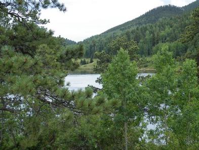
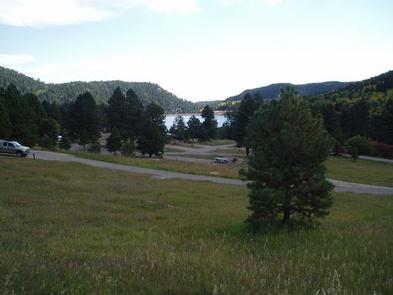
La Vista Campground is situated in a meadow overlooking the west side of the 40-acre Lake Isabel. It is set along the Frontier Pathways and Historic Byway in the Wet Mountains along one of the Colorado Birding Trails.

Lake Isabel is one of the few lakes in Colorado developed purely for recreation purposes. Built by the Civilian Conservation Corps, the lake attracts many campers who come to hike, canoe, fish and spend time bird watching. St. Charles Creek flows near the campground and offers additional fishing opportunities.

Recreation

Lake Isabel welcomes non-motorized boating and fishing. Brown and brook trout are stocked in the lake and the St. Charles headwaters reap brook trout.

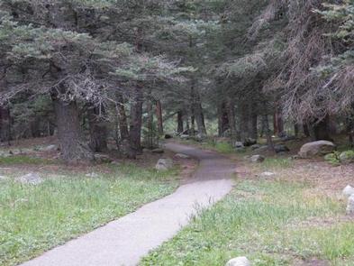
Visitors can enjoy hiking, bicycling or motorcycling on either the Snow Slide Trail and Cisneros Trail. The 15-mile Cisneros Trail, also open to ATV riders, leads to the heart of the Wet Mountains, through forests and open, wildflower speckled valleys. Along the way, the trail connects to St. Charles Trail, which heads to St. Charles Peak.

Facilities

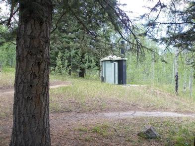
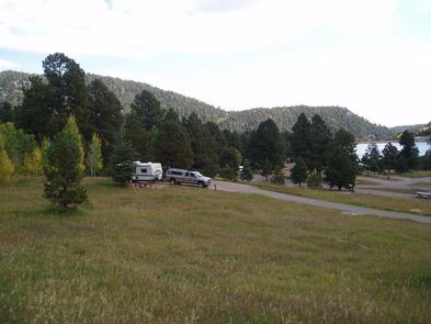
Walk-in tent sites are 15 to 50 yards from the parking spurs. RV sites come with electric hookups and all sites include a picnic table, campfire ring and access to vault toilets and drinking water.

Natural Features

Shady pine and aspen trees are scattered throughout the campground. At 8,600 feet, the area enjoys cool summer days, a welcome relief from the heat in the plains far below.

The Pike and San Isabel National Forest includes over a million acres of wilderness and over half of Colorado’s mountain peaks that reach above 14,000 feet.

Nearby Attractions

A nearby lodge provides paddle and rowboat rentals, groceries and a restaurant. Golf courses are about 15 minutes away.

Reservation

More from CampingHiking.net:

OCRACOKE CAMPGROUND, North Carolina Campground Images, Info & Reservations

Directions The campground is located off North Carolina Route 12, three miles east of Ocracoke Village and ten miles west of Hatteras inlet ferry terminal. Phone 252-928-6671 Activities BOATING, CAMPING, FISHING, VISITOR CENTER, SWIMMING SITE Keywords CG04,OCRACOKE Campground,Cape Hatteras National Campgrounds,OCRACOKE,OCRACOKE Related Link(s) Rec Area Info & Images North Carolina

SLIDE GROUP AREA, New Mexico Campground Images, Info & Reservations

Directions Located in southeast New Mexico, Slide Group Area is approximately 20 miles east of Alamogordo. From Alamogordo, take Highway 82 east 16 miles. Just before Cloudcroft, turn right (south) on Highway 130, go approximatley 2 miles. Turn right (west) on NM 6563, the Sunspot Highway Go approximately 1/4 miles.

TAMARACK CABIN, Oregon Campground Images, Info & Reservations

Directions From Lexington, OR, take Highway 74/207 east to Heppner. Continue south, on Highway 207. At the junction in Heppner, bear right to continue south on Highway 207 for 39 miles through Heppner, Ruggs, Hardman and past Anson Wright County Park to the junction of Highway 207 and Forest Road

PEACE VALLEY CAMPGROUND, Idaho Campground Images, Info & Reservations

Directions From Garden Valley, Idaho, take Forest Road 698 north approximately 16 miles north. Turn right at the junction of FR 698 and FR 671. Take FR 671 for about 10 miles to the campground, which is on the left-hand side of the road. Phone 541-351-1182 Activities BIKING, CAMPING, HIKING,

WRIGHTS LAKE, California Campground Images, Info & Reservations

Directions Take Highway 50 east of Placerville, California, for 11 miles. Turn left onto Ice House Road and continue for 9 miles, then turn right onto Wrights Lake tie road. After 2 miles, turn left onto Wrights Lake Road. Phone 831-245-6891 Activities CAMPING, FISHING, HIKING, DAY USE AREA, SWIMMING SITE,

THE NARROWS, Kentucky Campground Images, Info & Reservations

Directions From Glasgow, KY: Take 31-E south for 10 miles, turn right on 1318. Follow signs into campground entrance. Phone 270-646-3094 Activities CAMPING, HIKING, DAY USE AREA Keywords NARROWS,THE NARROWS,THEN,BARREN RIVER LAKE,BARREN RIVER,BARREN LAKE Related Link(s) Rec Area Info & Images Kentucky State Tourism Kentucky State Road Conditions Overview The