BASIN CAMPGROUND, NH Campground Reservation, Info, Images, Map, Directions

BASIN CAMPGROUND, New Hampshire Campground Images, Info & Reservations

Directions

From Fryeburg, Maine, take Highway 113 north 15 miles to the campground.

Phone

603-447-5448

Activities

BIKING, BOATING, CAMPING, FISHING, HIKING, PICNICKING

Keywords

BASI,WHITE MOUNTAIN NF -FS

Related Link(s)

Rec Area Info & Images

Forest Service Concessionaire

New Hampshire State Road Conditions

New Hampshire State Tourism

Overview

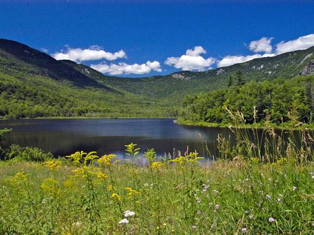
Basin Campground is located in a rustic, remote part of White Mountain National Forest in New Hampshire, about 15 miles north of Fryeburg, Maine. It is a small facility with access to hiking and mountain biking trails and proximity to a small pond for fishing and canoeing.

The White Mountains boast pristine forests, clear mountain streams and rivers and the tallest peaks in the Northeast. The forest encompasses nearly 800,000 acres in New Hampshire and western Maine, and is one of the most popular in the country.

Recreation

Hikers will enjoy exploring the 4.5-mile Basin Trail, which leaves from campground, and numerous other hiking and mountain biking trails within a short drive.

Trout fishing is available in Basin Pond. The pond’s calm waters are also ideal for canoeing.

The area hosts four alpine and five nordic ski areas, which provide year-round recreation opportunities such as skiing, hiking, mountain biking, outdoor concerts, interpretive trails, special events and regional and national skiing and snowboarding races.

Learn more about recreation in the national forest.

Facilities

Basin Campground hosts a mix of tent-only and standard sites along a single loop near Basin Pond. Accessible restrooms and drinking water are provided. There are no showers or a dump station.

Natural Features

The campground is in a pleasant mixed hardwood forest a short distance from the 23-acre Basin Pond.

The national forest is home to many species of northern wildlife, including moose, white-tailed deer and black bear. Almost 200 species of birds, including the rare Bicknell’s Thrush, live in the White Mountains.

Nearby Attractions

The town of Fryeburg, Maine has groceries, restaurants and gas. Campers might enjoy a scenic day trip to the Presidential Range, which consists of the tallest mountains in the forest, including the 6,288-ft. Mount Washington, the highest peak north of the Smoky Mountains and east of the Mississippi River.

Reservation

More from CampingHiking.net:

PINEY CAMPGROUND AND BOAT LAUNCH, Montana Campground Images, Info & Reservations

Directions From Hwy 1 take Georgetown Lake Road over dam. Follow signs; Piney will be 2 miles on your left. Phone 4062108199 Activities BIKING, BOATING, CAMPING, FISHING, HIKING, SWIMMING SITE, SWIMMING, STAR GAZING, WATER ACCESS Keywords Related Link(s) Rec Area Info & Images Montana State Tourism Montana State Road Conditions

FROSTY BAY CABIN, Alaska Campground Images, Info & Reservations

Directions This cabin is on the south shore of Frosty Bay, which is on the Cleveland Peninsula of the mainland. Access is 32 miles by float plane or 36 miles by boat from Wrangell. There is a mooring buoy anchored in the bay for use by cabin guests only. Anchorage

PINE REST CAMPGROUND, Oregon Campground Images, Info & Reservations

Directions From Sisters, OR: Travel 9.6 miles northwest on Highway 20, then 6.1 miles north on Forest Road 14, then 1.5 miles north on Forest Road 1419. Phone 541-323-1746 Activities CAMPING Keywords Related Link(s) Rec Area Info & Images Oregon State Road Conditions Oregon State Tourism Overview Pine Rest Campground

FORT PICKENS CAMPGROUND, Florida Campground Images, Info & Reservations

Directions Physical Address (NO MAIL SERVICE): 1400 Fort Pickens Road, Pensacola Beach, FL 32561 From I-10, take I-110 S to Pensacola. Take U.S. Highway 98S/FL Highway 30 over Pensacola Bay to Gulf Breeze. Follow 98 through Gulf Breeze, turn right onto FL Highway 399 to Pensacola Beach. Pay $1/vehicle at

SHERWOOD CAMPGROUND, Oregon Campground Images, Info & Reservations

Directions From I-84 at Hood River, head south on highway 35 toward Mt. Hood. Just past the Tamanawas Falls trailhead parking, the Sherwood Campground is on the right. Phone 541-386-6366 Activities CAMPING Keywords Related Link(s) Rec Area Info & Images Oregon State Road Conditions Oregon State Tourism Overview Sherwood campground

SULOIA LAKE CABIN, Alaska Campground Images, Info & Reservations

Directions Accessible generally from late April through mid November. Located 30 air miles northwest of Sitka on Chichagof Island (within West Chichagof-Yakobi Wilderness Area). Access by floatplane takes about 20 minutes from Sitka. For geographic features surrounding cabin, refer to USGS topographic map Sitka B-6. Phone 907-747-6671 Activities BOATING, CAMPING,