WOLF CREEK CALIFORNIA, CA Campground Reservation, Info, Images, Map, Directions

WOLF CREEK CALIFORNIA, California Campground Images, Info & Reservations

Directions

From Placerville, get on Highway 50 and head east for 21 miles to Icehouse Road. Turn left 21 miles to turnoff. Then go three-quarters of a mile to campground.

Phone

831-245-6891

Activities

BIKING, BOATING, CAMPING, FISHING, HIKING, WATER SPORTS, WILDLIFE VIEWING, SWIMMING SITE, BIRDING, WATER SKIING

Keywords

WOLA,ELDORADO NF – FS

Related Link(s)

Rec Area Info & Images

California State Tourism

California State Road Conditions

Forest Service Concessionaire

Overview

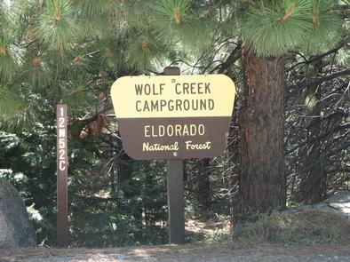
Wolf Creek Campground is a modern facility on the north shore of Union Valley Reservoir. The reservoir offers plenty of opportunities for water activities like sailing, boating, swimming and fishing. Bring a bike to explore the neighboring bike trail.

Eldorado National Forest includes the famed gold mining territory of the 1800s. Remnants of the days of the California Gold Rush are all around the region.

Recreation

The paved Union Valley Bike Trail spans 4.8 miles with an easy climb of 300 feet. The trail connects campgrounds on the east side of the lake, starting from Wench Creek on down to Jones Fork Campground. Interpretive signs along the trail tell the story of the use and development of water resources in Union Valley. This trail can be used by both hikers and bikers.

Anglers seek rainbow, brown and mackinaw trout or kokanee salmon. The reservoir also offers opportunities for swimming, water skiing and boating. The nearest boat ramp is at Yellowjacket Campground.

Facilities

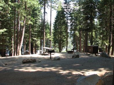
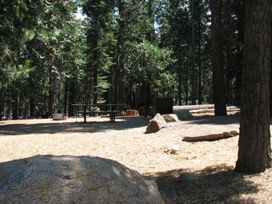
Sites in this two-loop campground come with picnic tables, campfire rings and bear-proof food storage lockers. Most of the family sites will accommodate up to five small tents (1-2 person) or two medium-sized family tents (4-6 people). Vault toilets and drinking water are provided.

Single, double and group campsites for up to 25 or 50 guests are all reservable. Some sites are tent-only.

A host is on-site, and firewood may be available for a fee (more campground details).

Natural Features

At an elevation of 4,900 feet, Wolf Creek sits in the Crystal Basin of the Sierra Nevadas. This is an area known for granite peaks, alpine lakes and pine forest.

The climate is similar to that of the Mediterranean with warm, dry summers and cold, wet winters.

An abundance of wildlife can be found within the Sierra Nevada Range, including black bears, mule deer, bobcat, gray fox, bighorn sheep, pikas, martens and a variety of squirrels. Several species of reptiles, amphibians and birds also inhabit the area.

Nearby Attractions

The Desolation Wilderness is nearby, offering the opportunity to get away from the crowds and enjoy the serenity of nature.

Reservation

More from CampingHiking.net:

ELKMONT CAMPGROUND, Tennessee Campground Images, Info & Reservations

Directions From Cherokee, NC: Take Newfound Gap Road (aka U.S. 441) North through the park into Tennessee. Turn left at Sugarlands Visitor Center. Follow Little River Road approx. 4.5 miles. Turn left at the Elkmont Campground sign and proceed 1.5 miles to the campground office. From Gatlinburg,TN: Take Newfound Gap

OLD KUTTAWA, Kentucky Campground Images, Info & Reservations

Directions From Nashville, take I-24 West to Exit 40. Turn left on 62 and then right on Highway 295. Follow Highway 295 to recreation area entrance. Phone LAKE BARKLEY RESOURCE MANAGERS OFFICE: 270-362-4236 Activities BOATING, FISHING, DAY USE AREA, SWIMMING SITE Keywords OLDK,LAKE BARKLEY,KUTTAWA,OLD KUTTAWA,BARKLEY LOCK & DAM Related Link(s)

RIDGE ROAD, Georgia Campground Images, Info & Reservations

Directions From I-20 take Exit 183 (Appling). Go north on HWY 221 approximately 6 miles. At 4-way stop, go left (GA HWY 47) and drive approximately 5 miles. Campground road is on right. Follow signs. Phone 706-541-0282 Activities CAMPING, SWIMMING SITE Keywords RIDG,J STROM THURMOND LAKE Related Link(s) Rec Area

TWIN LAKES DAY USE AREA, Georgia Campground Images, Info & Reservations

Directions From Interstate 85, take exit 14 to Highway 187 north. Immediately after passing Clemson Research Center, turn left on Fants Grove Road and follow directional signs to the park. 189 SHELTER DRIVE, Pendleton, SC 29670 Phone 888-893-0678 HARTWELL PROJECT OFFICE Activities BOATING, FISHING, PICNICKING, DAY USE AREA, SWIMMING SITE,

KIRBY COVE CAMPGROUND, California Campground Images, Info & Reservations

Directions From San Francisco (travelling north):  Cross the Golden Gate Bridge and take exit 442 onto Alexander Avenue. This will be the exit after the Vista Point. Continue straight for about a mile, and then turn left onto Bunker Road. Travel through the Baker-Barry Tunnel and continue straight until you

SPENCER CREEK, Oklahoma Campground Images, Info & Reservations

Directions Campground is 15 miles from Oologah, Oklahoma via county roads. Phone 918-341-3690 Activities BOATING, CAMPING, FISHING, VISITOR CENTER, WATER SPORTS, SWIMMING SITE Keywords SPEN,OOLOGAH LAKE,OOLOGAH LAKE Related Link(s) Rec Area Info & Images Oklahoma State Road Conditions Oklahoma State Tourism Overview Spencer Creek is located on Oologah Lake in