HICKORY CREEK, TX Campground Reservation, Info, Images, Map, Directions

HICKORY CREEK, Texas Campground Images, Info & Reservations

Directions

Due to construction on the I-35E bridge, the directions to the campground have changed if approaching from the north. Take I-35E south to Exit 460 – Meadow Oaks Rd/ Corinth Parkway. Stay on the I-35E access road heading south, go through the red light at Swisher Rd. Turn right onto Ventana Rd, go to the stop sign and turn left onto Point Vista Road. The campground is 1201 Point Vista Road, Hickory Creek, TX 75065.

Phone

469-645-9100(NOT FOR RESERVATIONS)

Activities

BOATING, CAMPING, FISHING, HIKING, DAY USE AREA

Keywords

HIC1,LEWISVILLE LAKE,LAKE DALLAS,GARZA LITTLE ELM,LEWISVILLE LAKE

Related Link(s)

Rec Area Info & Images

Texas State Tourism

Texas State Road Conditions

Overview

Hickory Creek sits on the extremely popular Lewisville Lake near Dallas, Texas. The almost 30,000-acre reservoir attracts a fair amount of visitors in summer months with warm water temperatures and excellent fishing opportunities.

Recreation

Visitors at Lewisville Lake enjoy picnicking, swimming, boating, fishing and relaxing. Photographers will stay entertained with wildlife and colorful sunsets, while hikers and bikers like to explore the 50 miles of natural surface and paved trails surrounding the lake.
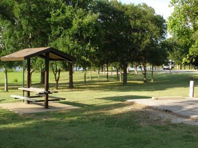
Facilities

The large campground boasts 121 sites with electric hookups. Tent primitive walk-in sites are not available at this time. Park amenities include hot showers, a dump station, and boat ramp.

Natural Features

The lake stems from the Elm Fork of the Trinity River in northern Texas, and offers little visibility, but plenty of room for boating and watercraft.

The park sits on the Hickory Creek Arm of Lewisville Lake, very near to the suburbs of Dallas, Texas.

Nearby Attractions

Several public golf courses are located around the lake, and horseback riding opportunities are available, too. Hickory Creek is just 35 miles away from downtown Dallas.

Reservation

More from CampingHiking.net:

WALDE LOOKOUT CABIN, Idaho Campground Images, Info & Reservations

Directions From Kooskia, ID, take Highway 12 East to Kamiah. Turn left onto Woodland Road for half a mile, then take the second right onto Glenwood Road (Road 100). Stay on this paved road until you reach the junction with Yakus Creek Road (Road 519). Park here (be sure to

CADDO DRIVE, Arkansas Campground Images, Info & Reservations

Directions From Interstate 30 take exit 78. Merge onto State Highway 7 north for 6 miles. Turn left onto Edgewood Road and continue 3 miles to Caddo Drive. Phone 870-246-5501 Activities BOATING, CAMPING, FISHING, WILDLIFE VIEWING, SWIMMING SITE Keywords CADV,DEGRAY LAKE,DEGRAY LAKE,CADDO,DeGray Lake Related Link(s) Rec Area Info & Images

Fort Hunt, Virginia Campground Images, Info & Reservations

Directions From Interstate 395, take exit 10B for George Washington Memorial Parkway. Merge onto the parkway and continue for about 12 miles. Turn right onto Fort Hunt Road and continue to the park. Phone 202-439-7325, OR 703-235-1530 Activities HISTORIC & CULTURAL SITE, HIKING, PICNICKING, GUIDED INTERPRETIVE WALKS Keywords CG15,FORT HUNT

RIPPLEBROOK, Oregon Campground Images, Info & Reservations

Directions From Estacada, travel east on Highway 224 for 26 miles to the campground, which is just past the Ripplebrook Camp Store. Phone 503-630-5721 Activities CAMPING, FISHING, WATER SPORTS Keywords RIPP,MT. HOOD NF – FS Related Link(s) Rec Area Info & Images Oregon State Tourism Forest Service Concessionaire Oregon State