PARKSVILLE, SC Campground Reservation, Info, Images, Map, Directions

PARKSVILLE, South Carolina Campground Images, Info & Reservations

Directions

Located off SC-28 in Parksville, SC.

Phone

800-533-3478

Activities

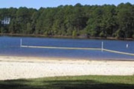
BOATING, FISHING, PICNICKING, DAY USE AREA, SWIMMING SITE, SWIMMING, WATER ACCESS, SOFTBALL FIELDS

Keywords

PARV,J STROM THURMOND LAKE

Related Link(s)

Rec Area Info & Images

South Carolina State Tourism

South Carolina State Road Conditions

Overview

Parksville Recreation Area is a rural park in McCormick County, South Carolina on J. Strom Thurmond Lake. It is located along South Carolina State Highway 28/221 and features 70,000 surface-acres of water and 1,000+ miles of shoreline for boating, water skiing, swimming, fishing, hiking and picnicking.

Recreation

Thurmond Lake provides some of the best fishing, hunting, and water sports in the southeastern United States. Anglers fish for largemouth bass, bream, crappie, catfish and striped bass. The large lake offers endless boating, water skiing, jet skiing, canoeing and swimming opportunities.

Facilities

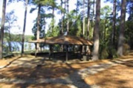
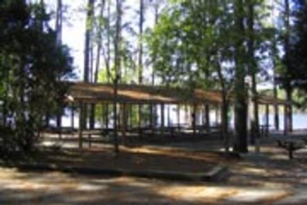
Parksville Recreation Area is a wooded day-use area with two group picnic shelters. Amenities include flush toilets, drinking water, a boat ramp, dock, playground and ball field. Shelter 1 has electrical hookups and can accommodate up to 90 people; Shelter 2 can accommodate up to 36 people but has no electrical hookups.

Natural Features

Hot, humid summers and mild, pleasant winters characterize this heavily wooded area on the shore of Thurmond Lake. A mixed pine and hardwood forest covers the site, providing summer shade and fall color. Elevation is 335′ above sea level.

Wildlife is abundant around the lake. Visitors regularly see southern bald eagles, osprey, migratory waterfowl, wild turkeys and whitetail deer.

Nearby Attractions

Numerous parks and recreation areas lie around Thurmond Lake, providing additional boating, swimming, hunting, and hiking opportunities. Nearby cities house museums, art galleries, zoos, restaurants, and shopping areas.

The Augusta National Golf Club hosts the Masters Golf Tournament annually the first week of April.

Reservation

More from CampingHiking.net:

SILVER CREEK GROUP CAMPGROUND, California Campground Images, Info & Reservations

Directions Travel 23 miles east of Placerville on Highway 50. Turn north and travel 9 miles on Forest Road 3 (Ice House Road). Look for signs to Silver Creek Campground. Phone 831-245-6891 Activities BIKING, BOATING, CAMPING, FISHING, HIKING, WATER SPORTS, WILDLIFE VIEWING, SWIMMING SITE, BIRDING Keywords SILG,ELDORADO NF – FS

GIRD POINT, Montana Campground Images, Info & Reservations

Directions From Hamilton, Montana, travel east on Highway 38 for about 7 miles. Turn north onto Gird Road/Forest Road 714 and continue for about 13 miles to the Gird Point Lookout Trailhead. The tower is approximately 1/2 mile hike from the parking area. Phone 406-821-3913 Activities BIKING, CAMPING, HIKING, WILDLIFE

REDFISH CABIN, Idaho Campground Images, Info & Reservations

Directions Renters should check winter road reports online at 511.idaho.gov or by calling 511 or 1-888-432-7623 prior to travel. October 15, November 30: From Stanley: Intersection of Hwy 21 and Hwy 75, drive south on Hwy 75 4.25 miles to Redfish Lake Road (FS Road 214). The turn is near

HANKS CREEK, Texas Campground Images, Info & Reservations

Directions From Zavalla, TX, take State Hwy 147 northeast for 1/4 mile, then turn north on FM 2109, go 8 miles to FM 2801. Turn right (east) on FM 2801 and go 2 miles to the park entrance. Follow signs into the campground. Phone 409-384-5716 Activities BIKING, BOATING, CAMPING, FISHING,

ANGEL LAKE, Nevada Campground Images, Info & Reservations

Directions Take Interstate 80 to the West Wells exit. Turn south on Angel Lake Road (State Route 231) and travel 12 miles to the end of the road at Angel Lake. Phone 775-752-3357 Activities BOATING, CAMPING, FISHING, HIKING, WILDLIFE VIEWING Keywords ANGL,RUBY MOUNTAINS,HUMBOLDT-TOIYABE NF-FS Related Link(s) Rec Area Info &