PIEDMONT PARK, MO Campground Reservation, Info, Images, Map, Directions

PIEDMONT PARK, Missouri Campground Images, Info & Reservations

Directions

From Piedmont, MO, follow Missouri State Highway HH. Travel on Highway HH for 6 miles to the top of the dam. Turn right and follow signs into campground.

Phone

573-223-7777 (CLEARWATER LAKE PROJECT OFFICE) 573-223-4432 (PIEDMONT PARK GATE HOUSE)

Activities

BOATING, CAMPING, SWIMMING SITE

Keywords

PIED,CLEARWATER LAKE,PIEDMONT,PARK ABOVE THE DAM,CLEARWATER LAKE

Related Link(s)

Rec Area Info & Images

Missouri State Road Conditions

Missouri State Tourism

Overview

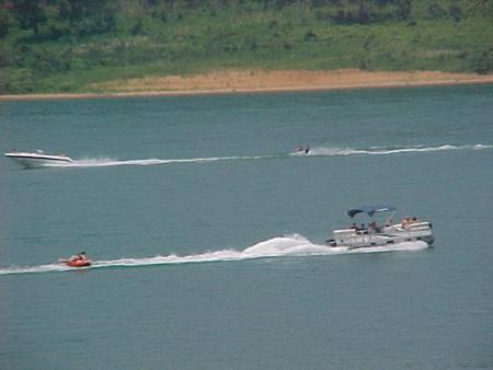
Piedmont Park is a spacious, activity-dense recreation area on the shores of Missouri’s Clearwater Lake. Water sport enthusiasts love the lakes diverse offerings, from boating to jet skiing and canoeing to swimming.

Clearwater is considered a "wilderness lake" because it lacks private boat docks and offers plenty of unspoiled shorelines to explore. The beautiful area is enhanced each spring by flowering shrubs and trees like the redbud, hawthorn, dogwood and wild plum.

Recreation

Wildlife viewing is popular with wetland waterfowl, fox, deer and geese.

Picnicking is also a favorite pastime, as is lounging on the beach, boating and fishing.

Facilities

Piedmont Park Campground offers 97 sites, including many with electric and water hookups. Additional amenities include a dump station, hot showers, picnic shelters, a boat ramp, playgrounds and a swimming area.

Natural Features

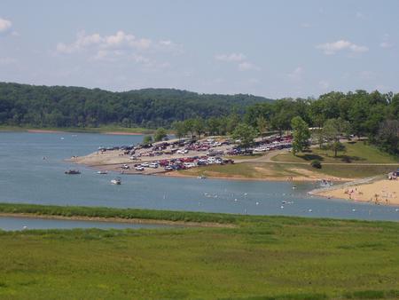
Visitors can sit under the shade of a sycamore or maple tree and look out across the lake to the lush but rugged terrain of the Ozark foothills.

The vicinity is noted for the grandeur of its hills, natural springs, and general outdoor beauty. The shoreline is studded with high picturesque bluffs covered with sweet williams, indented bays and quiet coves.

Nearby Attractions

In the area, campers enjoy visiting traditional drive-in movie theaters, the Sam A. Baker State Park, local golf courses, and the historic Civil War site at Fort Benton.

Reservation

More from CampingHiking.net:

LAKE MICHIGAN AT ST. IGNACE, Michigan Campground Images, Info & Reservations

Directions W 3853 US-2 Moran Michigan 49760 From Mackinac Bridge, take Highway 2 approximately 18 miles west to the campground entrance. Phone 906-203-9872 Activities BOATING, CAMPING, HIKING, WILDLIFE VIEWING, SWIMMING SITE Keywords LAKM,LAKE MICHIGAN CAMPGROUND,MICHIGAN LAKE CAMPGROUND,UPPER PENINSULA MICHIGAN LAKE,LAKE MICHIGAN IN THE UPPER PEN,LAKE MICHIGAN AT ST IGNACE,LAKE MICHIGAN,HIAWATHA

DRAKE PEAK LOOKOUT, Oregon Campground Images, Info & Reservations

Directions From the Lakeview Ranger District Office, travel 6 miles north on Highway 395, and turn right on Highway 140. Take Highway 140 east for 8 miles, then turn left on Forest Road 3615. Continue on Forest Road 3615 for 7.5 miles and turn right on Forest Road 019. Follow

OLD HIGHWAY 86, Missouri Campground Images, Info & Reservations

Directions From Branson, Missouri, take Highway 65 and turn west onto Highway 86. After 6 miles turn north on Highway UU and follow signs to the campground. Phone 417-779-5376 Activities BIKING, BOATING, CAMPING, FISHING, HIKING, PICNICKING, VISITOR CENTER, WATER SPORTS, WILDLIFE VIEWING, DAY USE AREA, SWIMMING, KAYAKING Keywords OL86,TABLE ROCK

AVONDALE, Tennessee Campground Images, Info & Reservations

Directions From Nashville, TN, take I-65 N to TN-386/Vietnam Veterans Blvd. Take exit 9 from TN-386/Vietnam Veterans Blvd, turn right onto Shute Lane. Continue straight onto Avondale Access Road. Follow signs into recreation area. Phone (615) 822-4846 Activities BOATING, CAMPING, FISHING, KAYAKING, CANOEING, WATER ACCESS Keywords AVON,OLD HICKORY LAKE,OLD HICKORY

COLD SPRINGS PEAK CABIN, Idaho Campground Images, Info & Reservations

Directions From Missoula, Montana, drive to Greer, Idaho. Follow State Highway 11 to Weippe. Continue on toward Pierce. Turn right onto French Mountain Road 250. Follow Road 250 (paved for 17 miles, gravel thereafter) to the Bungalow Bridge, which spans the North Fork Clearwater River. Turn right and remain on