PIONEER POINT, CA Campground Reservation, Info, Images, Map, Directions

PIONEER POINT, California Campground Images, Info & Reservations

Directions

From Bakersfield, California, take Highway 178 east to the town of Lake Isabella. From Lake Isabella take 155 north about 1.5 miles to Pioneer Point Campground.

Phone

760-376-1815

Activities

BOATING, CAMPING, FISHING

Keywords

PIOP,LAKE ISABELLA,KERN VALLEY,SEQUOIA NF – FS

Related Link(s)

Rec Area Info & Images

California State Road Conditions

California State Tourism

Forest Service Concessionaire

Overview

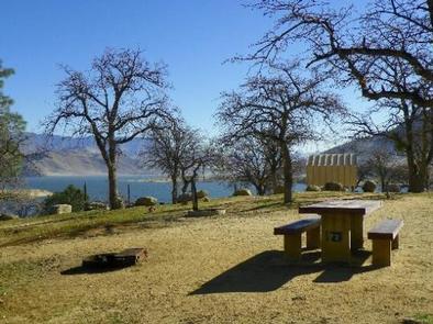
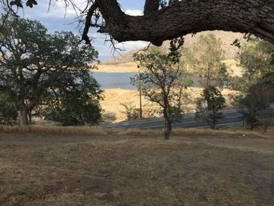
Reservations not being accepted. Pioneer Point is a high-desert campground near Lake Isabella in the Sequoia National Forest. The 11,000-acre lake is actually a reservoir, one of California’s largest, and it marks the division between the Upper and Lower Kern Rivers.

Recreation

The focal point of this year-round campground is Lake Isabella, where campers can swim, water ski, windsurf and more.

The lake is known for trout fishing during the colder months, offering anglers a variety of species, including black and white crappie, bluegill, catfish and largemouth bass.

Facilities

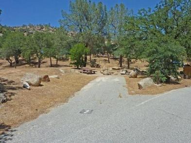
This 73-site campground, directly across the street from Lake Isabella, is open year-round. Some sites offer sweeping lake views, and a playground in the campground offers enjoyment for children.

Lake access is less than a mile from the campgrounds. The town of Lake Isabella is a 2-mile drive away.

This facility is operated by Sequoia Recreation, a division of California Land Management and comments are welcome; comment forms are available from campground hosts or online.

Natural Features

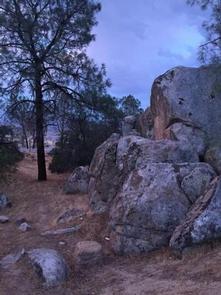
The Sequoia National Forest, located at the southern end of the Sierra Nevada in central California, takes its name from the giant sequoia, the world’s largest tree, which grows in more than 30 groves on the Forest’s lower slopes.

The Forest comprises about 1.1 million acres, and elevations range from about 1,000 to 12,000 feet, creating precipitous canyons and mountain streams with spectacular waterfalls such as Salmon Creek Falls and Grizzly Falls.

Nearby Attractions

The campground provides a great base for day trips to the Trail of a Hundred Giants and numerous Sequoia groves in the Giant Sequoia National Monument. You cannot access Sequoia National Park with a day trip.

The Giant Sequoia Mercantile offers a wide variety of books, maps, gifts, local art, camping supplies and other merchandise.

Reservation

More from CampingHiking.net:

DEEP CREEK GROUP CAMP, North Carolina Campground Images, Info & Reservations

Directions Seasonal phone is 828-488-3184 From downtown Bryson City, NC: Follow signs to Deep Creek, 3 miles away. Phone 828-488-3184 OR 865-436-1261 Activities HISTORIC & CULTURAL SITE, CAMPING, FISHING, HIKING, HORSEBACK RIDING, VISITOR CENTER, WILDLIFE VIEWING Keywords CG31,Great Smokey Mountains National Park,Great Smoky Mountains National Park,”Flaming Gorge National Recreation Area”

CURLEW CAMPGROUND, Idaho Campground Images, Info & Reservations

Directions Take the Snowville, Utah, exit off Interstate 84, northwest of Tremonton. Continue north on the paved highway for 6.5 miles. Turn left (north) at the Curlew Campground sign, then go another half-mile on a gravel road to the campground. From Holbrook, Idaho, travel 24 miles west of Malad and

TIPSAW LAKE, Indiana Campground Images, Info & Reservations

Directions From St. Croix, Indiana, travel south on State Route 37 about 5 miles to the Tipsaw Lake sign. Turn right and continue about 3 miles to the campground. Tipsaw Lake is only 3 miles from Interstate 64. Phone 812-843-4891 Activities BIKING, BOATING, CAMPING, FISHING, HIKING, HUNTING, SWIMMING SITE Keywords

LEIGH CREEK CAMPGROUND, Wyoming Campground Images, Info & Reservations

Directions From Ten Sleep, WY, drive 7.5 miles on Hwy 16 to FSR 018 (WY Hwy 436). Bear right and travel nearly 1 more mile to the campground. Phone 406-587-9054 Activities BIKING, BOATING, CLIMBING, FISHING, HIKING, WILDLIFE VIEWING, HOTEL/LODGE/RESORT PRIVATELY OWNED, OFF ROAD VEHICLE TRAILS, KAYAKING, STAR GAZING, BIRDING, NON-MOTORIZED

Loft Mountain Campground, Virginia Campground Images, Info & Reservations

Directions From Washington, D.C., metro area, travel west on Interstate 66 to exit 43A. Take US Highway 29 south approximately 55 miles to Ruckersville, Virginia, then take US Highway 33 west to Shenandoah National Park and Skyline Drive Swift Run Entrance. Follow Skyline Drive south approximately 15 miles and turn