TRILLIUM, OR Campground Reservation, Info, Images, Map, Directions

TRILLIUM, Oregon Campground Images, Info & Reservations

Listen

Directions

From Portland, travel southeast on Highway 26 for about 40 miles. Turn right a mile east of Government Camp. Continue 2 miles to the campground entrance.

Phone

503-630-5721

Activities

HISTORIC & CULTURAL SITE, CAMPING, INTERPRETIVE PROGRAMS, FISHING, HIKING, DAY USE AREA, SWIMMING SITE

Keywords

TRIL,MT. HOOD NF – FS

Related Link(s)

Rec Area Info & Images

Oregon State Tourism

Oregon State Road Conditions

Forest Service Concessionaire

Overview

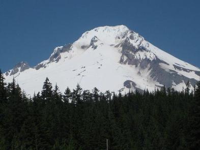
Trillium Lake Campground is a beautiful and popular campground not far from the quaint town of Government Camp. It provides spectacular views of majestic Mt. Hood, Oregon’s highest point. The campground is well-known for its scenery and abundant recreational opportunities, as well as being a great, family-friendly place to camp.

Recreation

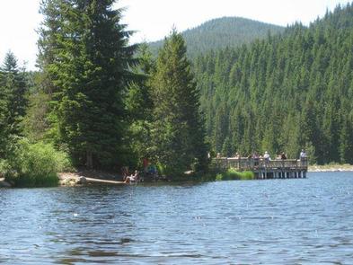
Boating, swimming and fishing are popular on 63-acre Trillium Lake. A small boat ramp is available within the campground and a larger ramp is available in the nearby day-use area. An accessible fishing pier is also available. Anglers cast for a variety of trout.

The 2-mile Trillium Shoreline Trail circles the lake, and parts of it are accessible. Visitors also enjoy hiking and biking on other trails in the vicinity. Tours of the area’s historical sites are also popular.

Facilities

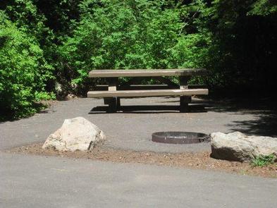
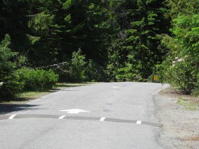
The campground offers dozens of single and double sites for tent and RV camping. Some first-come, first-served sites are available, as well as some fully accessible sites. Parking surfaces are mostly paved, but some are gravel.

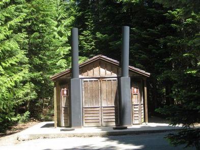
Each site is equipped with a table and campfire ring with grill. Accessible vault toilets and drinking water are provided. An accessible picnic shelter is adjacent and can accommodate up to 30 people. Parking is available.

An accessible amphitheater within the campground can be reserved for day use and can accommodate up to 30 people. Educational programs are held on weekends throughout the summer.

Natural Features

The campground is located about 40 miles southeast of Portland, in the Mt. Hood National Forest. It sits alongside Trillium Lake at an elevation of 3,600 feet, and is nestled in a shady, mixed conifer forest that provides privacy between campsites.

Nearby Attractions

Timberline Lodge, a National Historic Landmark on Mt. Hood, is located within 10 miles of the campground.

Reservation

More from CampingHiking.net:

SPRINGFIELD, Georgia Campground Images, Info & Reservations

Listen Directions From Interstate 85 in South Carolina, take exit 11 onto Highway 187 south. Turn on Providence Church Road and follow signs to the park. 1915 PROVIDENCE CHURCH ROAD Anderson, SC 29625 Phone 888-893-0678 Activities BOATING, CAMPING, FISHING, SWIMMING SITE Keywords SPRF,HARTWELL LAKE PROJECT Related Link(s) Rec Area Info

CRANE VALLEY, California Campground Images, Info & Reservations

Listen Directions From Fresno, California, take Highway 41 north through Oakhurst. Turn right on Forest Road 222, towards Bass Lake. Keep right for 3.5 miles to the campground. Phone 559-642-3212 Activities BOATING, CAMPING, INTERPRETIVE PROGRAMS, FISHING, HIKING, WATER SPORTS, SWIMMING SITE Keywords CRVA,BASS LAKE OAKHURST AR,SIERRA NF – FS Related

BUSHAY RECREATION AREA, California Campground Images, Info & Reservations

Listen Directions From the South (San Francisco, Santa Rosa, Ukiah): Follow Highway 101 North towards Ukiah. Approximately 5 miles north of Ukiah, take Highway 20 East. Continue on Highway 20 East for approximately 3 miles. Just after you see Lake Mendocino on your right, you will cross a tall bridge.

HALF MOON LAKE CAMPGROUND, Wyoming Campground Images, Info & Reservations

Listen Directions To reach the campground from Pinedale, drive to the east side of town and turn northeast onto the Fremont Lake road, passing the Pinedale Ranger District Office. Continue straight on the main road for approximately 10 miles to Half Moon Lake Road. Turn right onto road and continue

SEELY CREEK GUARD STATION, Utah Campground Images, Info & Reservations

Listen Directions From Orangeville, travel west on State Highway 29 to Joe’s Valley Reservoir. At the reservoir, turn right and follow the road around to the other side. When you start heading away from the reservoir and toward the plateau, you’ll pass Orange Olsen Administrative Site on the right and

EAST TWIN, Wisconsin Campground Images, Info & Reservations

Listen Directions Drive 4 miles north from Clam Lake on County Highway GG. Turn right (east) on Forest Road 190 and continue for about one mile to the campground. Phone (715) 634-4821 OR (715) 264-2511 Activities BIKING, BOATING, CAMPING, FISHING, HIKING Keywords EATW,CHEQUAMEGON-NICOLET NF – FS Related Link(s) Rec Area