COLD CREEK, CA Campground Reservation, Info, Images, Map, Directions

COLD CREEK, California Campground Images, Info & Reservations

Directions

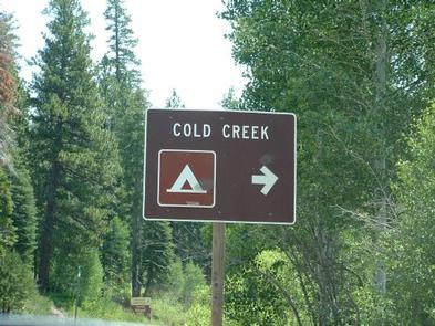
From Truckee, California, take Highway 80 north to Highway 89 approximately 20 miles. The campground is on the left side of the highway. From Sierraville, head south on Highway 89 approximately 5 miles, the campground will be on the right side of the highway.

Phone

(530) 994-3401

Activities

CAMPING, FISHING, HIKING, SWIMMING SITE

Keywords

COCR,TAHOE NF – FS

Related Link(s)

Rec Area Info & Images

California State Road Conditions

California State Tourism

Overview

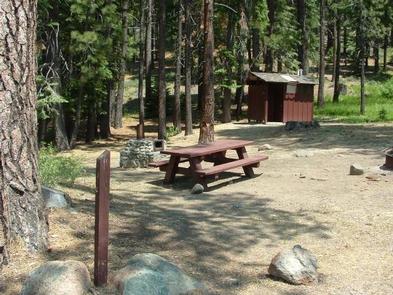
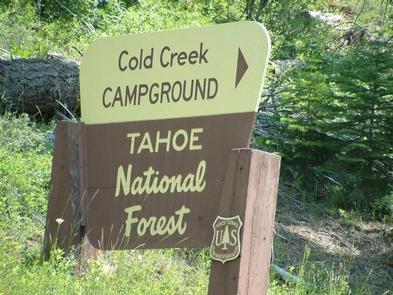
Cold Creek Campground is located on Highway 89, 4.5 miles south of Sierraville, California. The facility location makes Cold Creek a great base camp for a variety of recreational activities, including fishing, hunting, hiking and biking. This is a small campground recommended for tent camping and small campers. Large RVs will not be able to make the turnaround exit at this facility. There are a couple of hike-in sites within this campground that share a small parking area toward the back of this facility. This facility is operated and maintained by the Tahoe National Forest.

Recreation

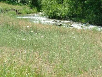
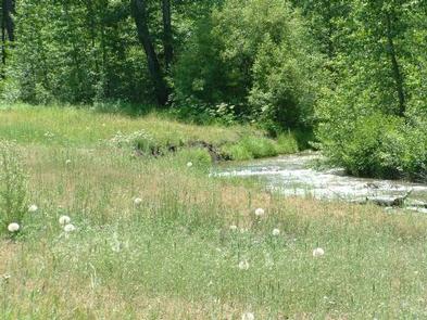
Cold Creek offers rainbow trout fishing and swimming. Cottonwood Creek Botanical Trail and Overlook Trail both begin at nearby Cottonwood Creek Campground.

Facilities

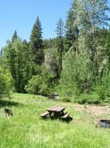
The campground offers single-family campsites, each equipped with a picnic table and campfire ring. Vault toilets are provided.

Natural Features

The campground lies in a meadow between Cold Creek and Highway 89. Jeffrey pine and white fir trees cover half the campground, while the other half is situated closer to the creek among cottonwoods, willow and aspen trees.

Nearby Attractions

Lake Tahoe is conveniently close, only 35 minutes away. Tahoe offers excellent boating, kayaking, fishing, hiking and scenic driving opportunities. Sardine Lakes, and the beautiful Lakes Basin is a 35-minute drive northwest via the Golden Chain/Highway 49. Stampede Reservoir is a 45-minute drive southeast.

Reservation

More from CampingHiking.net:

WHITEBREAST CAMP, Iowa Campground Images, Info & Reservations

Directions 971 Highway S71 Knoxville, Iowa 50138 From Knoxville, take County Highway T-15 northeast for 8 miles. Turn north onto County Highway S-71 and continue 2 miles, following signs to the campground. Phone 641-828-7522 Activities BIKING, BOATING, CAMPING, FISHING, HIKING, VISITOR CENTER, WILDLIFE VIEWING, DAY USE AREA, SWIMMING SITE Keywords

NORTH SANDUSKY DAY-USE, Illinois Campground Images, Info & Reservations

Directions From I-57 take take exit 77, and turn west onto Route 154. Continue for 4.5 miles, then turn south on Rend City Road. Continue through the stop sign to the park entrance. Phone 618-724-2493 Activities BIKING, BOATING, HIKING, SWIMMING SITE, DISC GOLF Keywords NSAD,REND LAKE,NORTH SANDUSKY,NORTH SANDUSKY DAY USE,NORTH

BIG HART CAMPGROUND, Georgia Campground Images, Info & Reservations

Directions From I-20, take Exit 172 (Thomson/HWY 78) and continue north 8 miles on HWY 78 to Russell Landing Road. Turn right and travel east 4 miles to campground. Phone (706) 595-8613 Activities CAMPING Keywords BIGH,J STROM THURMOND LAKE Related Link(s) Rec Area Info & Images Georgia State Tourism Georgia

PARKER CREEK, Arkansas Campground Images, Info & Reservations

Directions From Texarkana, Arkansas, take Interstate 30 east for 46 miles to Prescott. Continue onto Highway 19 north to Narrows Dam. After crossing the bridge across the Little Missouri River, proceed about 3 miles to the campground. Phone 870-285-2151 Activities BOATING, CAMPING, FISHING, HIKING, HUNTING, SWIMMING SITE Keywords PARR,Couch Valley,LAKE

WILLOW PRAIRIE CABIN, Oregon Campground Images, Info & Reservations

Directions From Butte Falls, take the Butte Falls-Fish Lake Highway (County Road 821) approximately 17 miles southeast to Forest Service Road 3738. Turn west on Forest Service Road 3738 and drive 1.3 miles to the intersection of Forest Service Road 3735. Continue west across the intersection, off the main road,