

Directions
The cabin is located near Crow Pass in the Chugach Mountains, 3 miles from the Crow Pass Trailhead. Cabin users can expect to encounter small stream crossings during wet periods.
Access: At mile 90, AK-1 S/Seward Highway (35 miles south of Anchorage). Turn left onto paved road leading to Mt. Alyeska Resort (Alyeska Highway). After 2 miles, turn left onto Crow Creek Road. Trailhead is at end of road (7 miles) and parking is available. Refer to USGS Map, Anchorage A6.
Phone
907-783-3242
Activities
HISTORIC & CULTURAL SITE, CAMPING, HIKING, HUNTING, WILDLIFE VIEWING
Keywords
CROW,CHUGACH NF – FS
Related Link(s)
Overview
Crow Pass Cabin is located about 500 yards off the Crow Pass Trail, which follows part of the former supply route for the Iditarod Trail. The trail is popular destination for its historic sites, stunning scenery and wildlife watching opportunities.
The cabin is an ideal stop for visitors hiking the entire length of the trail, which takes an estimated two to three days, or for visitors interested in a good base camp for mountain climbing or backcountry skiing in the area.
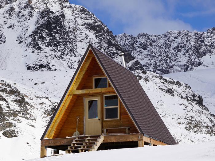
The site is only available for rent from June through October due to elevated avalanche during the winter and spring months. Please note, hazardous avalanche conditions may exist in this area as early as October andwell into June some years. Getting there requires a 3-mile hike from the Crow Pass Trailhead off Crow Creek Road with an elevation gain of 2,080 feet. The trail may have snow October through mid-June. There is a small stream crossings to navigate just before the Cabin. Visitors are responsible for their own travel arrangements and safety, and must bring several of their own amenities. More information on avalanche hazards in this area can be found at the Chugach NF Avalanche Center website (www.CNFAIC.org ). If accessing this Cabin in late Fall or early summer, please be prepared for winter conditions and/ or potential avalanche hazards affecting the route in along the Crow Pass Trail.
Recreation
The Crow Pass Trail is a picturesque 24-mile section (Girdwood to Eagle River) of the Iditarod National Historic Trail offering alpine hiking, trail running and sightseeing opportunities. The Cabin is ~3 miles from tthe Girdwood Traihead.
The section to the Cabin is a popular trail for families, but does have steep switchbacks in places. Interesting points between the trailhead and the cabin include the Monarch Mine ruins and several waterfalls. The trail continues past the cabin, revealing views of Raven Glacier and eventually the Eagle River. To continue the thru hike all the way to the Eagle River Nature Center (North Trailhead), it requires a substantial river crossing. THe Eagle River Nature Center is a good resource for updated info on the river crossing. (907) 694-2108.
Glaciers and peaks around the cabin offer experienced climbers a challenging adventure. Hunting is possible, but the activity is tightly regulated in this area with limited permits available from the State of Alaska.
Facilities
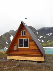
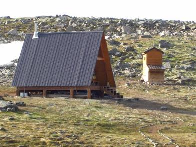
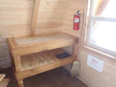
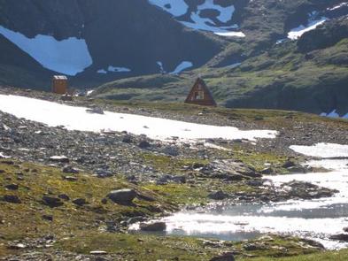
The cabin is a 16×16-foot, A-frame with a main floor and sleeping loft. It can accommodate 6 people and offers wooden bunks, a table with benches, fire extinguisher, first aid supplies, snow shovel, a broom and an outside pit toilet. An oil drip stove (Kerosene) is provided as a heat source though Cabin users are responsible to bring their own supply of Kerosene.
Electricity, water and fuel for the heater are not provided. Guests are responsible for supplying their own drinking water, kerosene for heater (typically 1 gallon/ day is sufficent), a cook stove, flashlights or lanterns, bedding, mattresses, toilet paper, garbage bags, cookware, dishes and utensils. A small creek is located near the Cabin but water should be treated before consumption.
Natural Features
The cabin is situated in the Chugach Mountains near Crystal Lake at an elevation of about 3,500 feet. It sits in open tundra above the tree line with vegetation of low shrubs, grasses and summer wildflowers.
Black and brown bears, wolves and moose inhabit the area (learn about bear safety). Dall sheep, mountain goats, marmots, arctic ground squirrels and white-tailed ptarmigan may be spotted on the rocky terrain surrounding the cabin.