TANIS MESA NORTH CABIN, AK Campground Reservation, Info, Images, Map, Directions

TANIS MESA NORTH CABIN, Alaska Campground Images, Info & Reservations

Directions

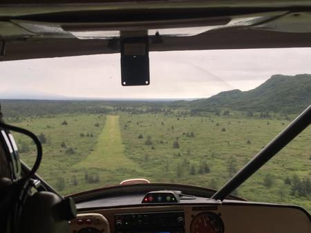
The cabin is located 50 miles southeast of Yakutat between Tanis Mesa and Brabazon Mountain Range. Access is by wheeled plane only via an 1,800-ft. airstrip at the cabin.

Phone

(907) 784-3359

Activities

CAMPING, HIKING, HUNTING, WILDLIFE VIEWING

Keywords

TANI,TONGASS NF – FS

Related Link(s)

Rec Area Info & Images

Alaska State Road Conditions

Alaska State Tourism

Overview

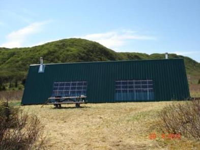
Tanis Mesa North Cabin is located in a duplex with Tanis Mesa South Cabin. The cabin is tucked between Tanis Mesa and the Brabazon Mountain Range, offering year-round relaxation and recreation.

The site can be accessed by wheeled plane, depending on conditions. An airstrip is adjacent to the cabin. Visitors are responsible for their own travel arrangements and safety, and must bring several of their own amenities.

Recreation

Tanis Lake is 2 miles north of the cabin and can be hiked to relatively easily except for the last quarter mile, which is dense brush. Hikers are rewarded with views of Fassett Glacier cascading into the lake’s northeast end.

The Brabazon Mountains offer opportunities for excellent mountain goat hunting. Moose and brown bear hunting is good around the cabin.

Facilities

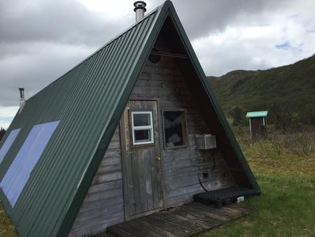
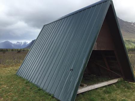
This is the north half of a 14×40-ft. A-frame stylecabin. It sleeps five people and comes equipped with four single bunks and a sleeping loft. The cabin also has a table and benches, oil heater, broom, picnic table, fire ring and outhouse. A 12×12-ft. meat shed is located outside, which is shared with Tanis Mesa South Cabin.

Water, heating oil and electricity are not provided. Visitors must supply #1 diesel oil the heater, as well as their own drinking water. Other items to bring include sleeping bags, sleeping pads, food, a cooking stove, cookware, plates, utensils, lanterns or flashlights, toilet paper, garbage bags, a fire extinguisher and fire starter. Visitors are expected to pack out trash and clean the cabin before leaving. Click here for more cabin details.

Natural Features

The cabin sits on mostly flat terrain surrounded by blueberry bushes. Interspersed stands of cottonwood, alder and willow begin about half a mile from the cabin. Visitors can enjoy views of Tanis Mesa, which sits half a mile to the southwest. Tanis Mesa is a unique geologic feature that stands about 500 feet above the cabin. The peaks of the Brabazon Range are a mile to the northeast, with elevations of over 3,000 feet. Wildlife in the Brabazon Mountain Range includes moose, brown bear and mountain goats.

Reservation

More from CampingHiking.net:

BLACK CANYON CAMPGROUND, Oregon Campground Images, Info & Reservations

Directions From Oakridge, Oregon, follow Highway 58 west about 8 miles to Black Canyon Campground, located 1 mile east of Lookout Point Reservoir. Phone 801-226-3564 Activities BIKING, BOATING, FISHING, KAYAKING Keywords BCAN,WILLAMETTE NF -FS Related Link(s) Rec Area Info & Images Oregon State Road Conditions Oregon State Tourism Forest Service

HARD ROCK CAMPGROUND, Oregon Campground Images, Info & Reservations

Directions From Blue River, OR, travel 4 miles east on Highway 126 to Aufderheide Drive (Forest Service Road 19). Turn right on Aufderheide Drive and continue south about 3/4 mile. Veer right at the Y and continue 10 miles to the campground. Phone 801-226-3564 Activities FISHING, WILDLIFE VIEWING Keywords HROC,WILLAMETTE

HORSFALL SAND CAMPING, Oregon Campground Images, Info & Reservations

Directions From North Bend Oregon, travel north on Highway 101 for 1 1/2 miles to Trans Pacific Parkway. Turn west (left) on Trans Pacific Pkwy, proceed 1 mile and turn right onto Horsfall Beach Road. For access via Horsfall Campground drive ½ mile on Horsfall Beach Road, the campground will

CRESCENT MOON, Arizona Campground Images, Info & Reservations

Directions 333 Red Rock Crossing Rd. Sedona, AZ 86336 From Phoenix, take I-17 north to State Highway 179. Go north on 179 for 13 miles to Sedona, then turn left on Highway 89A and continue south for 4 miles. Turn left on Upper Red Rock Loop Road and proceed another

MAGEE RANGERS CABIN, Idaho Campground Images, Info & Reservations

Directions Access #1: From I-90, take Exit #43 (Kingston) and drive 24 miles north on Forest Highway 9 (two lane paved highway) to the Prichard Junction. Continue on Forest Road 208 for 28 miles to the end of the pavement and the start of Forest Road 6310 (a gravel road

COEUR D’ALENE, Kansas Campground Images, Info & Reservations

Directions From US-75, take the Melvern Exit and travel 2 miles south on Melvern Lake Parkway, then 1 mile northwest on Coeur d’Alene Parkway (campground road). Phone 785-549-3318 Activities BOATING, CAMPING, HIKING, SWIMMING SITE Keywords COEU,MELVERN LAKE,MELVERN PROJECT,MELVERN SATE LK CDA OVERLOOK,COEUR D’ALENE PICNIC AREA,MELVERN STATE LK CDA OVERLOOK,MELVERN LAKE