


Directions
From Placerville, drive 21 miles on Highway 50, then turn left on Ice House Riverton Road. Go 23 miles north and turn right on Tells Creek Road. Then drive 5 miles east and turn left on the gated, dirt/gravel road to the bunkhouse, which is 0.5-miles ahead on the left side.
Winter access is from the Loon Lake parking area. From Highway 50, go 28 miles north on Icehouse Road and take the right fork to Loon Lake. Go 5 miles to the plowed parking area at the entrance to the campground road. A permit and gate combination is required and should be arranged prior to arrival with the Pacific Ranger Station at (530) 644-2349.
Phone
530-644-2324
Activities
CAMPING, FISHING, HIKING, HORSEBACK RIDING, WINTER SPORTS
Keywords
VANV,Crystal Basin,Icehouse Road,ELDORADO NF – FS
Related Link(s)
California State Road Conditions
Overview
Van Vleck Bunkhouse overlooks a 40-acre meadow and the Tells Peak portion of the Crystal Range of the Sierra Nevada, providing a rustic camping experience year-round. Built in 1957, the bunkhouse is the last remaining building at the Van Vleck Ranch site. The area was operated as a cattle ranch from the 1860s to the 1960s.
Summer guests can access the bunkhouse by road and enjoy the simple pleasure of the cabin and nearby hiking and horseback riding. Winter guests take on a more challenging adventure and must traverse a 6-mile trek with a 1,300-foot elevation gain to reach the bunkhouse. The route is marked by blue reflective diamonds and this journey is for intermediate to advanced backcountry skiers only.
Recreation
Popular summer activities include mountain biking, hiking, backpacking in Desolation Wilderness, stream fishing in Cheese Camp Creek, horseback riding, and bird watching. The Tells Creek Primitive Equestrian Trail leads into Desolation Wilderness.
In winter, cross country skiing or snowshoeing is required to reach the bunkhouse, so these are the featured activities of the trip.
Facilities
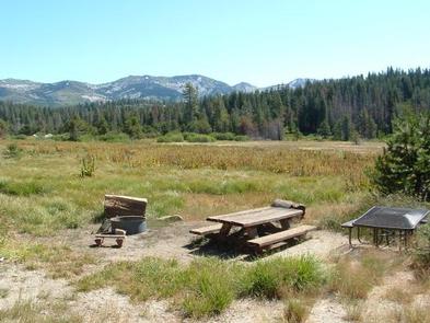
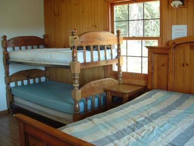
The bunkhouse has a 10×10′ deck, two rooms and an indoor bathroom with a flush toilet, shower and sink. Outside is a vault toilet and campfire ring. The parking area accommodates up to six vehicles. The main living area includes a kitchen, a table with chairs, a gas log stove, a sleeper sofa and a bunk bed. The bedroom has another bunk bed and a queen-size bed. The heater and cook stove operate on propane. During the summer season, the bunkhouse is supplied with well water. Hot and cold running water is available in the kitchen, bathroom sinks, and the shower. Please conserve water as the supply is limited and can run out during dry periods. Due to freezing temperatures, the water system is shut down during the winter. If available, melt and boil snow for water during winter months, or bring water with you. There is no electricity. Other items to bring year-round include food,utensils,pots,pans, bedding, toilet paper, paper towels,flashlights, headlamps,matches, a first aid kit and all other basic camping gear. Click here for more cabin details.
Natural Features
Van Vleck sits halfway up a small peak of the Sierra Nevada, about a half-mile from Cheese Camp Creek, at an elevation of 6,000 feet. The front deck overlooks a meadow and offers a view of the Crystal Range.
If skiing or snowshoeing to the bunkhouse, guests will pass over a bridge on the South Fork of the Rubicon River, and past a small aspen grove and Milkhouse Meadow.
Nearby Attractions
The nearest general store is at Ice House Reservoir, a 30-minute drive away. In winter this is closed, so the nearest store is in Pollock Pines, a 1.5-hour drive away.
Tells Creek Primitive Equestrian Campground is located near the bunkhouse.