

Directions
From Cascade, ID, head north on ID-55/Main Street toward McCall, ID. Turn right/east on FH-22/Warm Lake Road. Stay on this road for about 35 miles. Turn left/north on Road 413/Johnson Creek Road. Stay on this road for about 22 miles. The cabin sits on the right/east side of the road. Look for the Forest Service sign.
This is good unpaved road, but there are a few narrow and steep sections with few pull-outs, and there may be some washboard sections. Use low gears. Some sections of the road are steep.
For additional information, the Cascade District Office is located in Cascade on the north end of town off Highway 55 on the right side of the road. Office hours are Monday-Friday 8 a.m. to 4:30 p.m., closed on federal holidays. Please call the office at (208) 382-7400 for information on alternate routes.
Phone
208-382-7400
Activities
BIKING, HISTORIC & CULTURAL SITE, CAMPING, FISHING, HIKING, HUNTING, WILDLIFE VIEWING
Keywords
Yellow Pine,Golden Gate,Ice Hole,JCSS,Johnson Creek,Johnson Creek Guard Station (ID)
Related Link(s)
Overview
Johnson Creek Guard Station was built in 1922 and offers a charming mountain respite with modern conveniences. The cabin offers nearly everything needed for a pleasant and comfortable stay.
Peak season for the cabin is typically early June through late September. It can be accessed by most vehicles via dirt and gravel roads, but trailers are not recommended.
Recreation
The cabin is near several trailheads into the Frank Church – River of No Return Wilderness. These non-motorized trails are popular for hikers, mountain bikers and equestrians. Off-road vehicle trails are also nearby. Click here for an Idaho OHV safety message.
The South Fork Salmon River and Johnson Creek offer opportunities for fishing. Berry picking and hunting are popular pastimes in season.
Facilities
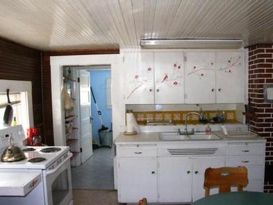
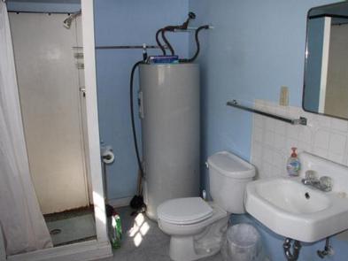
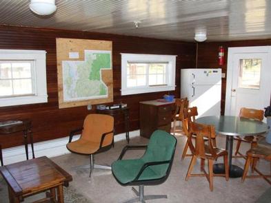
The rustic cabin has two twin beds with mattresses in the loft, as well as two cots, a couch and a heater. A full size bed is in separate bedroom. The kitchen is equipped with a table and four chairs, an electric range and a refrigerator. Cookware and utensils are provided, including saucepans, pots and lids, plates, bowls, cups, mugs, utensils, knives, a cutting board, salad bowl and cookie sheet. A modern bathroom with a flush toilet and shower is available. Two picnic tables, a campfire ring and two grills are located outside behind the cabin. Guests must bring garbage bags to pack out their own trash. Bedding, lanterns or flashlights, towels and emergency drinking water are not provided.
Natural Features
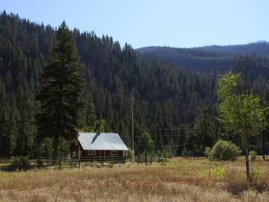
Johnson Creek sits in a pretty mountain meadow a stone’s throw from scenic Johnson Creek, a tributary of the South Fork Salmon River. Mountain slopes covered in dense pine forest surround the cabin.
Wildlife watchers may see deer, elk, bear and moose. Bald eagles are often spotted soaring overhead.
Nearby Attractions
The tiny community of Yellow Pine is a few miles north of the cabin and offers limited services. The popular Yellow Pine Music & Harmonica Festival is held annually in August.