FOX CREEK GROUP CAMP, OR Campground Reservation, Info, Images, Map, Directions

FOX CREEK GROUP CAMP, Oregon Campground Images, Info & Reservations

Directions

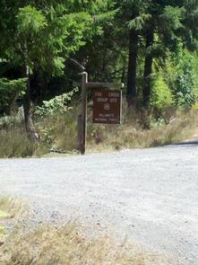
From Detroit, Oregon, drive east on State Highway 22. After crossing the bridge, take a left onto Forest Service Road (FSR) 46/Breitenbush. Follow FSR 46 for about 6.5 miles to Fox Creek Group Camp.

Phone

503-854-3366

Activities

CAMPING, FISHING, SWIMMING SITE

Keywords

Fox Creek,Fox Creek Group,Fox Creek Camp,FCGC,Fox Creek Group Camp

Related Link(s)

Rec Area Info & Images

Oregon State Tourism

Oregon State Road Conditions

Overview

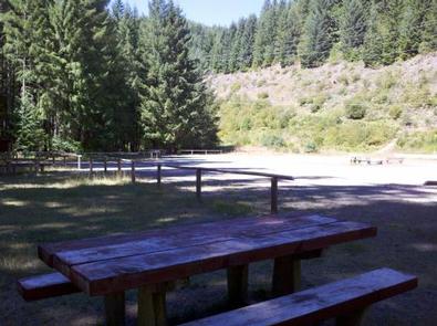
Fox Creek Group Camp is situated in a large, open area surrounded by dense forest near the point where Fox Creek flows into the Breitenbush River. Campers are sure to enjoy the variety of recreation like hiking, fishing and swimming. The group site accommodates tent campers plus RVs and trailers of any size.

Recreation

Fox Creek is a central access point to miles of scenic hiking trails. Willamette National Forest boasts 1,700 miles of trails, many of which trek through wilderness areas like the nearby Mount Jefferson Wilderness.

Campers can fish and swim in the Breitenbush River. Rainbow trout is the most common catch for anglers.

Facilities

No drinking water is available at this site. The group site caters to groups of up to 75 guests with ample parking. It is equipped with an accessible vault toilet, dumpster, campfire rings and picnic tables.

Natural Features

The campground is a short walk from the Breitenbush River, a tributary of Oregon’s North Santiam River, at an elevation of 1,700 feet. The river’s clean waters flow from short forks of snow melt in the Mount Jefferson Wilderness.

The Willamette National Forest stretches for 110 miles along the western slopes of the Cascade Range in western Oregon. The varied landscape of high mountains, narrow canyons, cascading streams, and wooded slopes offer excellent sightseeing and recreation opportunities.

Nearby Attractions

Head to Detroit Lake for a variety of activities including power boating, water skiing, kayaking and canoeing. Within 10 miles there are also opportunities for off-highway vehicle recreation, hunting, hiking, backpacking, scenic driving, and soaking in hot springs.

Reservation

More from CampingHiking.net:

SPINREEL, Oregon Campground Images, Info & Reservations

Directions From Reedsport Oregon, travel 11 miles south on Highway 101 to Spinreel Road. Turn right on Spinreel Road and proceed for a half mile to the campground entrance which will be on the left. Phone 541-271-6000 Activities CAMPING, HIKING, WILDLIFE VIEWING Keywords SPIN,TEST,SIUSLAW NF – FS Related Link(s) Rec

GOOSEBERRY RESERVOIR, Utah Campground Images, Info & Reservations

Directions From Fairview, Utah, travel north about a mile on Highway 89, to the junction with Highway 31. Travel east on Highway 31 for about nine miles, to the junction with Forest Development Road 124. Go north on Forest Development Raod 124 for three miles, to the campground. Phone (435)283-4151

LONE ROCK (CA), California Campground Images, Info & Reservations

Directions Take Arlington Road off Highway 89 (near Crescent Mills) to Taylorsville Road, continuing on Genesee Road and Indian Creek Road to Antelope Lake. Phone 530-283-0555 Activities BIKING, BOATING, CAMPING, INTERPRETIVE PROGRAMS, FISHING, SWIMMING SITE Keywords LON1,ANTELOPE LAKE,SUSANVILLE,TAYLORSVILLE,JANESVILLE,PLUMAS NF – FS Related Link(s) Rec Area Info & Images California State

ROCK CREEK GROUP, Utah Campground Images, Info & Reservations

Directions From Duchesne, Utah, take Highway 87 north 15 miles to the Mountain Home turnoff and turn left. Continue 2.5 miles north to the Rock Creek Store and turn left toward Rock Creek Canyon. Proceed approximately 14 miles to the campground. Phone 435-738-2482 Activities BIKING, CAMPING, FISHING, HIKING, WILDLIFE VIEWING

UPPER NARROWS, Utah Campground Images, Info & Reservations

Directions From Salt Lake City, head west on I-80 for 36 miles. Take the Stansbury-Tooele/Route 35 exit and travel south 3 miles to Route 138 West. Continue for 10 miles to Grantsville. Go through Grantsville to Cooley Street and turn south; go 5 miles to the South Willow Canyon turnoff.