WOODBINE CAMPGROUND, MT Campground Reservation, Info, Images, Map, Directions

WOODBINE CAMPGROUND, Montana Campground Images, Info & Reservations

Directions

Take Montana Highways 78 and 419 south of Columbus (on 1-90) 43 miles west of Billings, Montana.

Phone

406-587-9054

Activities

BIKING, CAMPING, FISHING, HIKING, WILDLIFE VIEWING

Keywords

None

Related Link(s)

Rec Area Info & Images

Overview

Woodbine Campground is remotely located adjacent to the Absaroka-Beartooth Wilderness in southwestern Montana, about three hours from Yellowstone National Park via the scenic Beartooth Highway. Red Lodge, Montana is 57 miles east; Nye is 7 miles north. The administering organization is Gallatin Canyon Campgrounds; e-mail: gccampgrounds13@gmail.com

Recreation

The Stillwater River and nearby streams and lakes offer great fishing opportunities for rainbow, brown and cutthroat trout.

Hiking the Woodbine Falls Trail is a popular activity among campers. The 1.5-mile round-trip trail begins in the campground and follows Woodbine Creek before ending at an impressive cascade.

The Stillwater Trail provides access to the Absaroka-Beartooth Wilderness and is open to hiking and horseback riding. The trail reaches beautiful Sioux Charley Lake after 3 miles and continues on another 20+ miles into the wilderness.

Facilities

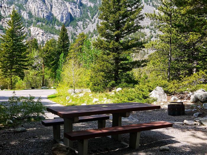
The campground offers single and group sites, some of which are accessible. Picnic tables and campfire rings with grills are provided, as are accessible vault toilets and drinking water.

Natural Features

Woodbine Campground is situated on the banks of the Stillwater River at an elevation of 5,300 feet. The campground is wooded and shady, with views of the surrounding snow-covered, 10,000 foot peaks.

A variety of wildlife, including deer, elk and bear, can be found in the surrounding area, creating prime opportunities for wildlife viewing.

Nearby Attractions

The Absarokee-Beartooth Wilderness Area is adjacent, boasting 700 miles of trails and hundreds of alpine lakes. The wilderness borders Yellowstone National Park and is a part of the 20-million-acre Greater Yellowstone Ecosystem.

The nearby town of Nye hosts Nye Goes Nuts annually in July. The popular event includes food, drinks, children’s games and the chicken chase, a crowd favorite.

The small community of Fishtail holds its annual Fishtail Family Fun Day at the end of June, with a pancake breakfast, vendor booths, a parade and live music.

Reservation

More from CampingHiking.net:

THE NARROWS, Kentucky Campground Images, Info & Reservations

Directions From Glasgow, KY: Take 31-E south for 10 miles, turn right on 1318. Follow signs into campground entrance. Phone 270-646-3094 Activities CAMPING, HIKING, DAY USE AREA Keywords NARROWS,THE NARROWS,THEN,BARREN RIVER LAKE,BARREN RIVER,BARREN LAKE Related Link(s) Rec Area Info & Images Kentucky State Tourism Kentucky State Road Conditions Overview The

WILLOW FLAT CAMPGROUND, Utah Campground Images, Info & Reservations

Directions From Preston, Idaho, head south on U.S. Highway 91 for approximately 3 miles. Turn east on the Cub River Road (Forest Road 406) and travel 3 miles past the Cache National Forest boundary to the intersection of Forest Road 406 and Forest Road 407. Bear right at the intersection,

SHERIDAN, Montana Campground Images, Info & Reservations

Directions From U.S. Highway 212, turn off at Eastside Road and go 2 miles to the campground. The entrance is on the left. Phone 406-587-9054 Activities BIKING, BOATING, CAMPING, FISHING, HIKING Keywords SHDN,CUSTER NF – FS,SHERIDAN Related Link(s) Rec Area Info & Images Overview Sheridan Campground is located seven miles

BLACK CANYON CAMPGROUND, Oregon Campground Images, Info & Reservations

Directions From Oakridge, Oregon, follow Highway 58 west about 8 miles to Black Canyon Campground, located 1 mile east of Lookout Point Reservoir. Phone 801-226-3564 Activities BIKING, BOATING, FISHING, KAYAKING Keywords BCAN,WILLAMETTE NF -FS Related Link(s) Rec Area Info & Images Oregon State Road Conditions Oregon State Tourism Forest Service

KATHLEEN LAKE CABIN, Alaska Campground Images, Info & Reservations

Directions Access to the cabin is by floatplane. It is about a 30-minute flight from Juneau. In fall, winter and early spring, the cabin may be inaccessible due to frozen lake surface (floatplanes cannot land). The lake is normally ice free from mid-May through November. Refer to USGS topographic map

BIG CREEK CABIN, Montana Campground Images, Info & Reservations

Directions From Livingston, drive south on Highway 89 for approximately 34 miles to Big Creek Road and a sign for Mountain Sky Guest Ranch. Turn right at the sign and follow Big Creek Road for about 5 miles to the cabin. High-clearance, four-wheel drive vehicles are strongly recommended. In winter,