RIVERSIDE AT DETROIT, OR Campground Reservation, Info, Images, Map, Directions

RIVERSIDE AT DETROIT, Oregon Campground Images, Info & Reservations

Listen

Directions

From Detroit, OR, take Route 22 toward Sisters. Go 14.2 miles to the campground on right side of the road.

From Sisters, head toward Detroit on Route 22. Go 43 miles to the campground on the left.

Phone

801-226-3564

Activities

FISHING, HIKING, BIRDING

Keywords

Riverside,Riverside Campground

Related Link(s)

Rec Area Info & Images

Oregon State Tourism

Oregon State Road Conditions

Forest Service Concessionaire

Overview

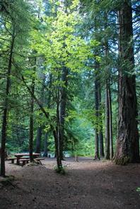
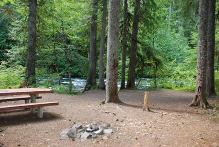
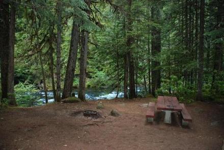
Riverside at Detroit Campground is an excellent outdoor retreat designed for campers more interested in a remote experience. Guests are greeted with grand, mature cedars and Douglas fir trees as they drive into the campground.

The Coffin Mountain Trail Area is located nearby, with splendid trails to explore like the Coffin Lookout and Bugaboo Ridge Trails.

Recreation

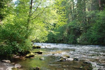
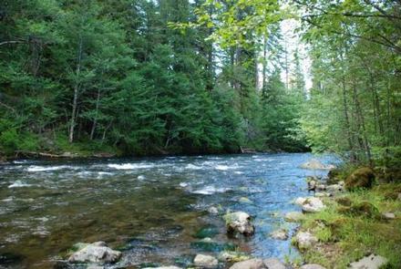
Anglers enjoy fishing for rainbow trout on the river. Among the many options for hiking and biking trails, the Mt. Jefferson-Pamelia Lake Trail Area is bound to please all types. Hikers looking for a challenging trail will enjoy the Minto Mountain Trail.

Facilities

This campground has 37 sites, 20 are reservable. The campground is comprised of two sections. The southeast (upriver) section has more secluded sites on a bluff overlooking the river. Northwest (downriver) sites have partial shade and a more open setting. Drinking water spigots can be found throughout the campground. Waste gray water disposal sites are provided. Firewood is available for sale on-site.

Natural Features

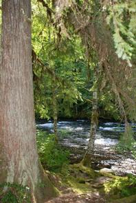
Riverside is located along the North Fork Santiam River at an elevation of 2,400 feet. Surrounding vegetation includes hemlock, rhododendron and fern, among the towering conifers.

The campground is in the North Santiam Travel Corridor of the Willamette National Forest. The forest covers 1.6 million acres on the western slopes of the Cascade Range.

Nearby Attractions

The Marion Forks Fish Hatchery, along Marion and Horn Creeks, is an interesting place to visit. Here, visitors can see rainbow trout, summer steelhead and spring chinook being harvested.

Reservation

More from CampingHiking.net:

FALES FLAT CAMPGROUND, Montana Campground Images, Info & Reservations

Listen Directions From Darby, travel south on Highway 93 for about four miles. Turn onto Highway 473 and continue southwest for 14 miles. Turn west onto Forest Road 468 and continue about 12 miles to the campground. Phone 406-821-3269 Activities BIKING, CAMPING, FISHING, HIKING, HUNTING, SCENIC DRIVE, HISTORIC SITES Keywords

CEDAR BREAKS PARK, Texas Campground Images, Info & Reservations

Listen Directions From I-35, take Farm to Market Road 2338 west for 3.5 miles to D.B. Wood Road. Turn left and continue for 2.5 miles. Turn right onto Cedar Breaks Road and follow signs to the park. Phone 512-930-5253 Activities BOATING, CAMPING, FISHING, HIKING, HUNTING, PICNICKING, PADDLING, MOUNTAIN BIKING Keywords

SANDY BEACH CAMP, Iowa Campground Images, Info & Reservations

Listen Directions From Interstate 380 (Shueyville, Iowa) take Exit 10 towards Shueyville. Travel east on 120th St. NW for 1.2 miles. At the stop sign, turn right onto NE Curtis Bridge Rd. Travel south on NE Curtis Bridge Rd for 1.1 miles. Turn left onto Sandy Beach Rd. NE and

COTTONWOOD (NE), South Dakota Campground Images, Info & Reservations

Listen Directions From U.S. Hwy 81 in Yankton, South Dakota, drive four miles west on South Dakota Highway 52, then south on Dam Toe Road and follow signs. Phone 402-667-2546. FOR RESERVATIONS, CALL 877-444-6777. Activities BIKING, BOATING, CAMPING, FISHING, HIKING, PICNICKING, WILDLIFE VIEWING, DAY USE AREA, PLAYGROUND PARK SPECIALIZED SPORT

TUNNEL MILLS II, California Campground Images, Info & Reservations

Listen Directions From east bound Interstate 80 take exit 158A or west bound Interstate 80 take exit 158B south to Emigrant Gap. After exiting the interstate take a right on Texas Hill Road towards Emigrant Gap. Continue on Texas Hill Road for about 8 miles and turn right into the

MONTY CAMPGROUND, Oregon Campground Images, Info & Reservations

Listen Directions From Sisters, OR: Travel 5.6 miles northwest on Highway 20, then 20.8 miles north on Forest Road 11, then 5.0 miles east on Forest Road 1170, and then 7.2 miles northwest on County Road 64. Phone 503-464-8515 Activities CAMPING, FISHING, WILDLIFE VIEWING Keywords Related Link(s) Rec Area Info