

Directions
13 miles south of Galena, IL off HWY 20, turn west on Blackjack and follow directional signs. DO NOT TAKE DIGGIN HILL RD.
Phone
RANGER STATION: 563-582-0881 / CAMPGROUND ENTRANCE STATION: 815-591-2326 (5-8 PM DAILY)
Activities
CAMPING, FISHING, PICNICKING, WILDLIFE VIEWING, DAY USE AREA, BIRDING, WATER ACCESS
Keywords
BLAN,MISSISSIPPI RV. RI
Related Link(s)
Illinois State Road Conditions
Overview
Blanding Landing is situated in a lush river valley on the east bank of the great Mississippi, just 13 miles from Galena, Illinois. Rich deposits of minerals line the landscape. In the early 19th century, miners from around the globe flocked to the area in search of wealth from minerals. This was the nation’s first mineral rush, predating California’s legendary Gold Rush.
Recreation
The Mississippi River draws crowds of anglers each year. The most popular species is the channel catfish. Bluegill, walleye, crappie and northern pike also live in these waters. Other activities include boating, picnicking and hunting.
Facilities
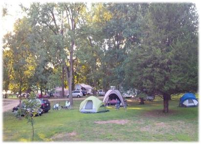
All campsites are on grass and most have electric hookups. A playground and showers are also available. Hardwood trees allow for natural shade in the area.
Natural Features
The campround is off the beaten path offering a quiet camping getaway. Nestled along the backwaters of the Mississippi River, this area is a well known birders paradise plus access to miles of great fishing. Thousands of years ago, Ice Age Glaciers divided and detoured around the northwest corner of Illinois. In their wake, clusters of rugged hills remain. Today, the winding country roads are perfect for leisurely drives.
Nearby Attractions
The town of Galena is 13 miles north, and attracts tourists for its quaint atmosphere, unique shops and historic buildings. Eighty-five percent of the buildings in the town are listed in the National Register of Historic Places.