HOOVER CAMPGROUND, OR Campground Reservation, Info, Images, Map, Directions

HOOVER CAMPGROUND, Oregon Campground Images, Info & Reservations

Directions

Drive 2.7 miles east of Detroit, OR on Highway 22. Turn onto Blowout Road/Forest Service Road 10, then go 0.75 miles west to the Hoover Group Site.

Phone

801-226-3564

Activities

CAMPING, FISHING, HIKING

Keywords

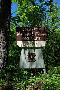
HOOG,DETROIT LAKE,WILLAMETTE NF -FS,Hoover Group Campground,Hoover Group Camp

Related Link(s)

Rec Area Info & Images

Oregon State Road Conditions

Oregon State Tourism

Forest Service Concessionaire

Overview

Hoover Campground rests on the shores of the sparkling Detroit Lake. The area is covered with towering trees, making for secluded, peaceful camping spots. Visitors enjoy fishing, boating on the lake, and hiking on the Stahlman Point Trail.

Recreation

Sailing, boating, water skiing and fishing are all excellent options for enjoying Detroit Lake. Catfish, rainbow trout and Kokanee salmon are among the most common species found in the lake. A convenient boat ramp is in the campground. Several hiking trails dot the area, including Stahlman Point Trail, which offers beautiful vistas of Detroit Lake and the surrounding area. The Hoover Nature Trail is a short footpath that delights many campers.

Facilities

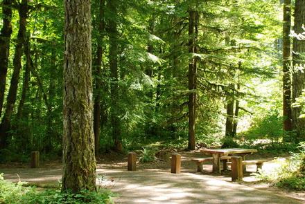
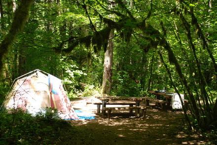
This campground has 35 standard sites, with 21 reservable, and 1 reservable group site. An interpretive trail and an accessible viewing and fishing platform are part of the campground. Each site has a campfire ring and picnic table. Flush toilets are available at the campground and the group campground has a vault toilet. Access roads are made from compacted rock and dirt. Firewood can be purchased on-site. In the day use area, there is about 1,000 ft. of shoreline. There is a dock for launching, loading and unloading only. There is no mooring allowed.

Natural Features

Hoover sits among Douglas fir and maple trees and large ferns at an elevation of 1,600 feet. The campground is located in the North Santiam Travel Corridor of Willamette National Forest. The forest covers 1.6 million acres on the western slopes of the Cascade Mountains.

Reservation

More from CampingHiking.net:

DOWNSTREAM POINT, Kansas Campground Images, Info & Reservations

Directions Take U.S. Highway 169 to Cherryvale, Kansas, and turn east onto Main Street. Continue through the town and turn right at the end of Main Street onto Olive Street. Go 1/2 a block and turn left onto County Route 5000. Proceed 4.5 miles to Big Hill Lake and follow

CAZIER CABIN, Wyoming Campground Images, Info & Reservations

Directions From Afton, WY, take Highway 89 north about 31 miles to Alpine, WY. At Alpine, turn right (south) onto Greys River Road (Forest Road 10138) and travel about 46 miles. The cabin is located on the right (west) side of the road. Access is along a low-speed gravel road.

RAMSHORN, California Campground Images, Info & Reservations

Directions From Downieville, take Highway 49 south for about 5.5 miles. The campground is on the right side of the highway. Phone (530)478-6253 Activities BIKING, CAMPING, FISHING, HIKING, HUNTING, SWIMMING, MOUNTAIN BIKING, KAYAKING, SCENIC DRIVE Keywords RAMS,TAHOE NF – FS Related Link(s) Rec Area Info & Images California State Road

GERLE CREEK, California Campground Images, Info & Reservations

Directions From Placerville, drive 21 miles east on Highway 50 to the Icehouse Road turnoff. Turn left and go 28 miles north. Take the left fork 3 miles to the campground. Phone 831-245-6891 Activities CAMPING, FISHING, HIKING, SWIMMING SITE Keywords GERL,ELDORADO NF – FS Related Link(s) Rec Area Info &

WARM SPRINGS REC AREA, California Campground Images, Info & Reservations

Directions Take Highway 101 to Healdsburg and exit on Dry Creek Road. Travel west another 11 miles to park boundary. Watch the road signs and make a left turn across from the visitor center to reach the Warm Springs Recreation Area. Phone 707-431-4533 Activities CAMPING Keywords WASP,LAKE SONOMA,LAKE SONOMA,Warm Springs