


Directions
From Sisters, Oregon, take Highway 20 west for about 12 miles. Turn north onto Jack Lake Road/FS Road 12 and continue for nearly 6 miles. Turn left onto FS Road 1260, then right onto FS Road 200. Sheep Springs will be on the right hand side.
Phone
541-323-1746
Activities
BIKING, CAMPING, HIKING
Keywords
SHSP,DESCHUTES NF – FS
Related Link(s)
Overview
Sheep Springs Horse Campground sits in the spectacular Metolius River Basin area in Deschutes National Forest.
In close proximity to snow-capped peaks, high elevation lakes, scenic rivers and several wilderness areas, this campground offers a variety of scenery and recreational opportunities for visitors.
Recreation
A favorite among horse enthusiasts, the campground provides visitors access to a variety of trails. Lakes, lava flows and thick forests provide the backdrop for horseback riding and hiking.
The Metolius-Windigo Trail, which offers a trailhead at the campground, is a long-distance trail open to horseback riders, hikers and bicyclists. More than 100 miles long, this trail begins near the Metolius River headwaters and runs south to Windigo Pass near Crescent Lake. Because of its lower elevation, this trail remains snow-free for longer than other nearby trails.
Facilities
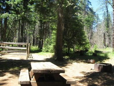
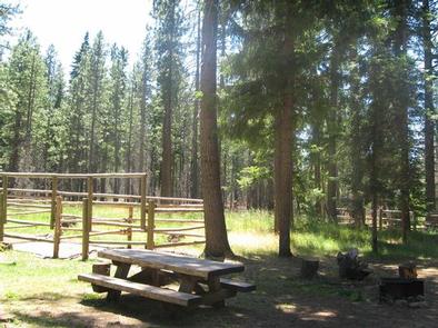
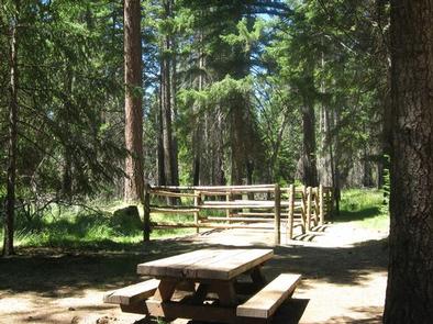
The campground offers 11 large equestrian sites, each equipped with a 4-place box stall. Picnic tables, campfire rings and grills and ample room for parking vehicles and trailers are also available at each site.
Drinking water and a vault toilet are also provided.
Natural Features
Located at an elevation of approximately 3,200 feet, campsites are interspersed among a towering canopy of old-growth Ponderosa pine and a variety of spruce and fir.
The Metolius River flows nearby, making its headwaters at Metolius Springs at the base of nearby Black Butte, a 3,076-foot cinder cone. The clear, cold river flows north from the springs through diverse coniferous forest and a landscape of volcanic activity.
The surrounding undeveloped wilderness, clean streams and diverse forests support an abundance of wildlife, including mule deer, coyote, and cougar. Migratory birds and native fish also call the area home.
Nearby Attractions
Visitors can explore wilderness areas, rivers, lakes, reservoirs, and approximately 1,600 miles of trails that comprise nearly 2.5 million acres the Deschutes National Forest and the adjacent Ochoco National Forest.
Lava Lands Visitor Center in nearby Bend, Oregon, is a great starting point for visitors to learn about the diverse landscape and history of the area through interpretive programs and exhibits.
Visitors can explore the Lava River Cave, also located in the Newberry National Volcanic Monument. At 5,211 feet in length, the northwest section of the cave is the longest continuous lava tube in Oregon.
The nearby town of Camp Sherman has basic supplies and restaurants available.