ALBENI COVE, ID Campground Reservation, Info, Images, Map, Directions

ALBENI COVE, Idaho Campground Images, Info & Reservations

Listen

Directions

From Highway 2 in Newport, Washington, turn south onto Highway 41. Follow for .5 miles and turn east on Fourth Street into Oldtown, Idaho. Follow for approximately 3 miles to the campground.

Phone

208-437-3133

Activities

BOATING, CAMPING, FISHING, PICNICKING, WATER SPORTS, WILDLIFE VIEWING, DAY USE AREA, SWIMMING

Keywords

ALBE,ALBENI FALLS DAM

Related Link(s)

Rec Area Info & Images

Idaho State Tourism

Idaho State Road Conditions

Overview

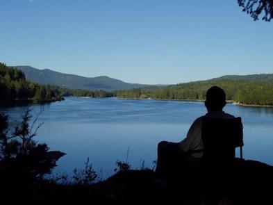
Albeni Cove is a small campground located just upstream from Albeni Falls Dam on the Pend Oreille.

Situated amongst firs, cedars and pines, Albeni Cove provides a rustic, but incredibly beautiful location for camping and recreation on the river.

Recreation

Water sports are the most common activity at Albeni Cove, including swimming, fishing and boating. Campers are likely to spot wildlife in the area, including bald eagles, osprey, a wide variety of birds, and most commonly, deer.

Facilities

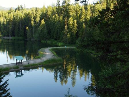
Albeni Cove Campground offers 14 campsites, all with picnic tables and grills. An on-site dock, boat ramp and swimming beach provide easy access to the water.

Natural Features

Albeni Falls Dam on the Pend Oreille River, provides flood control, power production and countless recreational activities for visitors year-round.

Behind the dam, the Pend Oreille River stretches 65 miles through a glacial-carved valley that separates three mountain ranges.

Lake Pend Oreille is surrounded by scenic mountains and is one of the largest and deepest natural lakes in the western United States, plunging to depths of more than 1,200 ft. in some areas.

Nearby Attractions

The Albeni Falls Visitor Center features exhibits on the history of the dam and the natural features of the area. Tours of the dam are given daily during the summer.

Charges & Cancellations

A $10.00 service fee will apply if you change or cancel your reservation. Late cancellations are subject to additional fees. For full details see NRRS Reservation Policy.

Reservation

More from CampingHiking.net:

WILSON NARROWS CABIN, Alaska Campground Images, Info & Reservations

Listen Directions The cabin is accessible by float plane only. It is located approximately 44 air miles northeast of Ketchikan on the mainland, north of Wilson Arm. The cabin sits on the south end of Wilson Lake. This cabin is in a designated Wilderness area, and access by helicopter is

MCKEEVER CABIN, Michigan Campground Images, Info & Reservations

Listen Directions Mckeever Cabin does not have a physical address. Vehicle access from the North: Take M-28 to FH 13, which is 3 miles east of Munising. Proceed south on FH 13 for 11 miles to FR 2163, located across from the road from Widewaters Campground. Vehicle access from the

SKATERS CABIN SHELTER, Alaska Campground Images, Info & Reservations

Listen Directions This Skater’s Cabin Shelter is approximately 13 miles from downtown Juneau. Access is via the Alaska Marine Highway or via Alaska Airlines. By ferry: Turn right out of the Ferry Terminal parking lot. Drive 1.7 miles to DeHart’s Store above Auk Bay marinas. Take a left turn onto

WELDON ISLAND, Georgia Campground Images, Info & Reservations

Listen Directions From Interstate 85, take Exit 4 and turn East onto Old Dobbins Bridge Road.Turn right on Andersonville Road and follow the brown directional signs. Hattons Ford ramp is located at the end of Andersonville Road. Townville, SC, 29689 Phone 888-893-0678 HARTWELL PROJECT OFFICE Activities BOATING, FISHING, PICNICKING, SWIMMING,

DAVIS CANYON CAMPGROUND, Utah Campground Images, Info & Reservations

Listen Directions Take U.S. Highway 89 north from Garden City, Utah, or south from Montpelier, Idaho, to St. Charles. Drive west from St. Charles along Forest Road 412 about 6 miles to the campground. Phone 541-351-1182 Activities BOATING, CAMPING, FISHING, HIKING, HUNTING Keywords None Related Link(s) Rec Area Info &