
Directions
Elk Creek is located off of US Hwy 50 between Gunnison and Montrose, along Blue Mesa reservoir.
Phone
970-641-2337
Activities
BIKING, BOATING, CAMPING, INTERPRETIVE PROGRAMS, FISHING, HIKING, HUNTING, VISITOR CENTER, WATER SPORTS, WILDLIFE VIEWING, DAY USE AREA, SWIMMING SITE
Keywords
ELKC,CURECANTI NATIONAL RECREATION,ELK CREEK CURECANTI NRA,CURECANTI
Related Link(s)
Colorado State Road Conditions
Overview
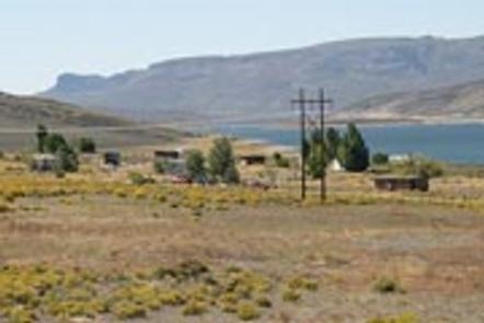
Elk Creek Campground is on the north shore of Blue Mesa Reservoir. The lake is Colorado’s largest body of water with 96 miles of shoreline and the largest Kokanee Salmon fishery in the United States.
The campground is part of the Curecanti National Recreation Area, which was named after a Ute Indian chief of the mid-19th century.
Recreation
Anglers delight in catching large salmon and rainbow trout, while water sports fans find excitement in windsurfing and water skiing.
Swimming is permitted throughout the 20-mile long reservoir and birders can find bald eagles here in the winter.
Facilities
Campfire programs are in full swing during the summer months.
There’s a marina adjacent to the campground that’s open late spring to early fall.
Concession run coin operated showers are nearby, open during summer months..
Cell phone service is limited. Electric hookups are in Loop D only for 30 and 50 amps.
Natural Features
At an altitude of 7,540 feet, Elk Creek is surrounded by a vast expanse of sagebrush. Trees are minimal because the reservoir gets less than 12 inches of rain a year.
Curecanti National Recreation Area is sandwiched between the towns of Montrose and Gunnison, Colorado. It spans three reservoirs, named for corresponding dams on the Gunnison River. These include the Crystal Reservoir, Morrow Point Reservoir and Blue Mesa.
Nearby Attractions
Head down to the Gunnison Diversion Tunnel, a National Historic Civil Engineering Landmark or visit the Morrow Point Reservoir at the beginning of the Black Canyon.
At morrow point, visitors can take a ranger-led pontoon boat through the upper Black Canyon. Find more tour information here.