

Directions
From Butte Falls, take the Butte Falls-Fish Lake Highway (County Road 821) approximately 17 miles southeast to Forest Service Road 3738. Turn west on Forest Service Road 3738 and drive 1.3 miles to the intersection of Forest Service Road 3735. Continue west across the intersection, off the main road, and on to a little dirt road. At the next junction, turn left and the cabin will soon be in sight.
Wheeled-vehicle access is usually possible only from late spring through fall. Vehicle access in winter is subject to weather conditions. Winter parking along Highway 140 is permissible in designated areas with an Oregon State Sno-Park permit. Winter access on skis or snowmobiles can range from 2 to 6 miles, and the difficulty level will be moderate to difficult depending on snow conditions.
Phone
541-560-3400
Activities
BIKING, HIKING, HORSEBACK RIDING, HUNTING, WINTER SPORTS, WILDLIFE VIEWING
Keywords
WLPR,SISKIYOU,ROGUE RIVER,ROGUE RIVER NATIONAL FOREST,SISKIYOU NATIONAL FOREST,ROGUE RIVER-SISKIYOU NATIONAL,ROGUE RIVER SISKIYOU NATIONAL,ROGUE RIVER-SISKIYOU,ROGUE RIVER SISKIYOU,ROGUE RIVER – SISKIYOU NF – FS
Related Link(s)
Overview
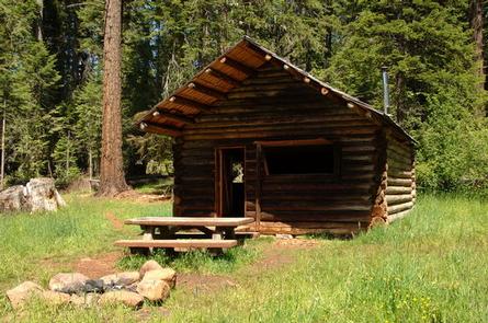
Willow Prairie Cabin is located in the southwest portion of the magnificent volcanic Cascade Mountain Range at the foot of Mt. McLoughlin, at an elevation of 4,300 feet. The Willow Prairie Guard Station cabin was constructed on the edge of the meadow in 1924 by a Forest Service road crew. Its main purpose at that time was as a firefighter guard station.
In 1990, the cabin was converted to a horse camp and was recently restored by local volunteers and employees of the Butte Falls Ranger District. Today it is available for rent by groups with or without horses.
Recreation
The cabin is adjacent to the Willow Prairie Campground , and is surrounded by 19 plus miles of horse trails. In addition to horseback riding, enjoy camping, hunting and winter sports, such as cross country skiing, snowshoeing and snowmobiling.
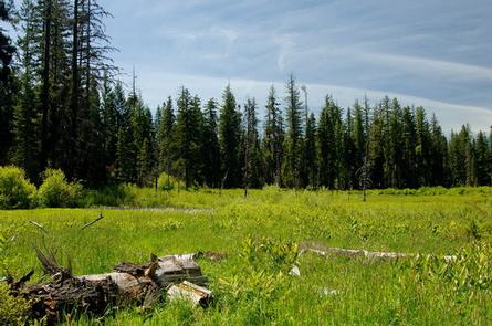
The wetlands adjacent to the cabin provide an excellent area for birding enthusiasts to watch for sandhill cranes, great blue herons, Canada geese, ducks and red-tailed hawks.
Facilities
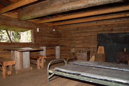
The one-room cabin can accommodate up to four people, however it is furnished with only two sleeping cots. It has two shutter-style windows without glass, a wood stove for heat, and rustic furnishings, including a table and chairs. There is counter space for meal preparation and places to hang lanterns. Water is available at the campground.
Outside amenities include a campfire ring and picnic table for outdoor dining. Firewood is often available intended for indoor use only, however the supply cannot be guaranteed. The supply may run low and what is there may have to be split by the visitor with the tools provided. Guests are encouraged to bring their own. A vault toilet is located in the adjacent campground near the cabin.
Guests must supply their own camp stove, cookware, utensils and dishes, sleeping bags, towels, dish soap, matches, first aid kit, light source, toilet paper and garbage bags.
There are four 12 x 12 foot paddocks and water troughs near the cabin for up to four horses.
Natural Features
The Rogue River-Siskiyou National Forest is composed of two distinct geological provinces – the Cascade Range and the Siskiyou Mountains.
The Cascade Range is dominated by snow-capped volcanic peaks such as 9,495 foot Mt. McLoughlin located within the Sky Lakes Wilderness. The Siskiyou area embodies the most complex and treasured plant communities in the Pacific Northwest. Wild rivers, biological diversity, remarkable fisheries resources, and complex watersheds define the Siskiyou.
Adjacent to the cabin and camp is a wetland area featuring a beaver swamp and several large ponds where wildlife abounds. From majestic sandhill cranes and Canada geese, to bull elk and deer, these species, along with many others, depend on the surrounding undeveloped wilderness, undisturbed wetlands, clean streams, and diverse forests to live.