
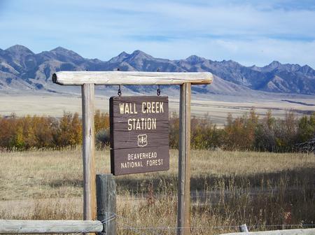
Directions
From Ennis, take US Highway south for about 18 miles to Indian Creek and the McAtee Bridge fishing access site. Turn right and go nearly 1 mile to junction just beyond bridge. Turn left and travel toward Wall Creek Wildlife Management Area for 2.7 miles to T junction. Turn left and stay on main road for 2.5 miles, through many twists and curves, to another T junction. Staying on main road, turn left and travel for about 2 miles. Turn right, through gate, at Wall Creek Station sign, and travel a half mile to another gate. Go through gate and cabin is just beyond. Rout is signed.Maps (Beaverhead-Deerlodge National Forest-South) may be purchased by calling the Madison Ranger District.
Phone
406-682-4253
Activities
BIKING, BOATING, CAMPING, FISHING, HIKING, HUNTING, WILDLIFE VIEWING
Keywords
WACR,WALL CREEK RANGER STATION,WALL,WALL CREEK,CREEK CABIN,WALL CABIN,CREEK,BEAVERHEAD-DEERLODGE NF -FS
Related Link(s)
Overview
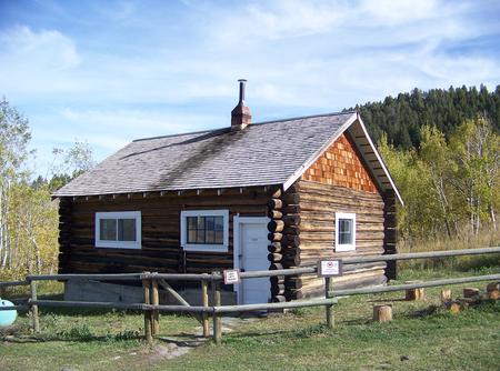
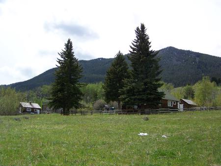
Wall Creek Cabin is a small dwelling that gives guests access to prime elk and deer viewing. The cabin is near a major wildlife refuge and herds can often be seen wandering nearby. It is typically open to the public from mid-May through November, offering ample opportunity to explore southwestern Montana. The facility was a ranger station until the 1940s. There are three log buildings at the site, including the small cabin, a barn and a main house, which is used by grazing permit holders. Only the smaller cabin is available for public use. Though usually quiet, there may be work activity associated with grazing management, with cowboys, horses and dogs at the site. The site can easily be accessed by vehicle and is open during late spring through early fall. Guests are responsible for their own travel arrangements and safety, and must bring several of their own amenities.
Recreation
Big game hunting is by far the most popular activity enjoyed by visitors to the cabin. The area and surrounding wilderness is thick with wildlife. Hunters must have appropriate licensure to hunt in the state of Montana, and hunting is only allowed in designated areas. Wildlife viewing is popular, as animals often come near the cabin. A variety of hiking and horseback riding trails are available in the area, as well as trails for off-road vehicles. Trailhead access is about a mile north of the cabin on Hyde Creek.
Facilities
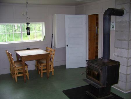
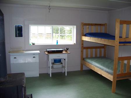
You must call the Madison Ranger District at 406-682-4253 Monday – Friday 8:00 am to 4:30 pm for the cabin combination. The office is NOT open on Federal Holidays. The primitive cabin is small, with a single room and an enclosed porch. It is equipped with two sets of bunk beds with foam pads that can sleep up to four people. Other amenities include a propane cook stove, propane lantern, table and chairs, cleaning supplies, basic cooking utensils, cooking pots and a wood stove for heat. Firewood may be stacked against the fence to the west of the cabin, but the firewood supply cannot be guaranteed. Split wood is stored in the box on the porch. A primitive outhouse with vault toilet is located 100 feet north of the cabin. The only water that may be available is at a spigot at the horse trough. Primarily for stock use, the water must be properly filtered, treated or boiled for drinking or cooking purposes. Propane is not provided for the cook stove or lantern, so guests will need to bring small disposable propane canisters. Cell phone service is minimal or nonexistent in the area. Other items to bring include sleeping bags and pillows, matches, flashlight, food, toilet paper and garbage bags. Guests are expected to pack out all trash and food and clean the cabin before leaving. The firewood supply should also be replenished.
Natural Features
The cabin is located on the edge of the Madison River Valley and the Gravelly Mountains at an elevation of 6,150 feet. It sits in an open, grassy area backed by forested slopes.
This is a popular destination for big game hunters and for wildlife lovers who want to view elk in the fall, due to its proximity to the Wall Creek Wildlife Management Area, which is also home to deer, moose, antelope and bears (learn more about bear safety).