
Directions
From Porterville,California, take Highway 190 east. Continue through Springville for approximately 8 miles to Wishon Drive. Turn left and travel about 4 miles. The cabin is at the entrance to Wishon Campground on the right hand side of the road.
From Bakersfield, California, take Highway 65 North to Highway 190 east and follow the directions above.
Phone
559-539-5230
Activities
BIKING, CAMPING, FISHING, HIKING, WILDLIFE VIEWING
Keywords
WISC,WISHON,SEQUOIA NF – FS
Related Link(s)
California State Road Conditions
Overview
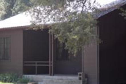
Wishon Cabin sits amid oaks and pines in the Southern Sierra Nevada Mountains in the Sequoia National Forest. The cabin, perched at an elevation of 3,900 feet, is located at the entrance of the Wishon Campground, about an hour drive from Springville, California.
The cabin was originally built in the 1930s by the Civilian Conservation Corps and was used by the Forest Service to house fire patrol, recreation workers and other personnel. It is now available for rent year-round, allowing visitors to enjoy the forest and available recreation.
Recreation
Popular activities in the immediate area include hiking and fishing.
Nearby activities include horseback riding, mountain biking, rock climbing, hunting and more. Giant Sequoia groves are within a hour drive.
Facilities
The one-story, two-bedroom cabin has electricity, hot and cold running water and a furnace for the cooler seasons. It has one bedroom equipped with a queen bed and a second bedroom equipped with two twin beds.
The living room has a futon that sleeps two, a couch, a dining table and six chairs. The cabin also has a fully-equipped kitchen including a stove, refrigerator, microwave, toaster, coffeemaker, pots and pans, dishes and utensils and a small table. The bathroom includes a flush toilet and tub-shower.
A picnic table and campfire ring are provided outside.
Guests should plan to bring linens, pillows, blankets, towels, toiletries, food and trash bags. Suggested additional items include toilet paper, paper towels, camp chairs, insect repellent and dish towels.
Natural Features
Wishon Cabin is withing walking distance to the Doyle Springs Trailhead. This trail travels north along the Middle Fork Tule River, through the Wishon Grove of giant sequoias, and eventually reaches the Mountain Home State Forest area, which also has many giant sequoia trees.
Because of the cabin’s elevation, visitors need to be prepared for a wide variety of weather, including warm afternoons, chilly nights and afternoon thunderstorms. It is also not unusual to have a dusting of snow during the fall and winter months.
Nearby Attractions
Additional family and friends can camp in the nearby Wishon Campground.
The Giant Sequoia Mercantile offers a wide variety of books, maps, gifts, local art, camping supplies and other merchandise.