WOODRING DAY USE AREA SHELTER, GA Campground Reservation, Info, Images, Map, Directions

WOODRING DAY USE AREA SHELTER, Georgia Campground Images, Info & Reservations

Directions

From Atlanta: Take Interstate 75 North until Exit 293, turn right onto Georgia Highway 411 North, travel approximately 30 miles; take a right onto Georgia Highway 136 East; proceed across railroad tracks; turn left onto Old Highway 411 North, continue approximately six (6) miles and turn right onto Highway 76, travel approximately 3.5 miles and turn right onto Woodring Branch Road; proceed almost five (5) miles and continue straight into Woodring Branch Day Use Area.

Woodring
5600 Woodring Branch Road
Ellijay, GA 30540

Phone

706-334-2248

Activities

BIKING, BOATING, FISHING, HIKING, HUNTING, DAY USE AREA, MOUNTAIN BIKING, KAYAKING, CANOEING, BIRDING

Keywords

Related Link(s)

Rec Area Info & Images

Georgia State Tourism

Georgia State Road Conditions

Overview

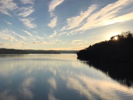
Woodring Day Use Area is located in the North Georgia Mountains about 70 miles north of Atlanta on Carters Lake. The sparkling waters and rugged shoreline provide a beautiful surrounding for a variety of outdoor recreational opportunities including camping, hiking, boating, mountain biking, fishing, hunting and picnicking.

Recreation

Boaters visit Carters Lake to enjoy its solitude and scenic beauty. Whether in a powerboat or sailboat on the open water or paddling along the shoreline in a canoe, Carters Lake offers enjoyable boating experiences for everyone. Fishing is a popular activity on the lake. Major species include bass (largemouth, smallmouth, hybrid, striped and spotted) crappie, walleye, bream and catfish.

Facilities

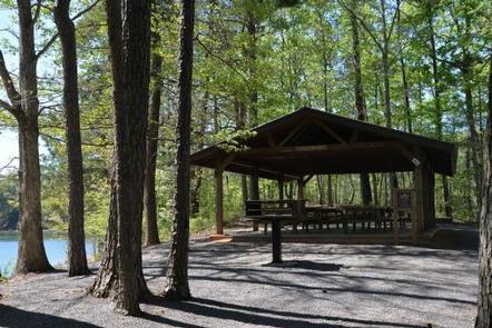
Woodring Day Use Area provides boaters with a launch ramp with two lanes and courtesy dock. The area also provides ample picnic sites and restrooms. The shelter (CL-11) seating capacity is 50 people maximum and parking capacity of 25 vehicles.

Natural Features

Carters Lake embraces a spectacular tract of foothills scenery in the Blue Ridge Mountains of North Georgia. It covers 3,200 surface acres and has 62 miles of undeveloped shoreline.

Nearby Attractions

The City of Ellijay is about 30 minutes away, offering restaurants, grocery stores and fuel, along with other amenities.

Charges & Cancellations

Please review the rules and reservation policies link at the bottom of the page.

Reservation

More from CampingHiking.net:

SAVENAC WEST COTTAGE, Montana Campground Images, Info & Reservations

Directions From Missoula, Montana, travel west on Interstate 90 for 90 miles to Exit 16 for Haugan. At the stop sign turn right. At the frontage road turn right and take the first left, crossing the cattle guard. Signs are onsite to follow. Maps are available online or for purchase

CAL-IDA, California Campground Images, Info & Reservations

Directions From Downieville, travel south on Highway 49 for about 13 miles. The campground is on the right side of the highway. Phone (530)478-6253 Activities BIKING, BOATING, CAMPING, FISHING, HIKING, HUNTING Keywords CALI,TAHOE NF – FS Related Link(s) Rec Area Info & Images California State Tourism California State Road Conditions

BLUE HERON CAMPGROUND, Tennessee Campground Images, Info & Reservations

Directions From 1-75 Northbound, take exit 141 for Oneida/Huntsville and turn left. Follow Highway 63 to the intersection of US-27 in Huntsville. Turn right and continue north on US-27 through Oneida for 18 miles. Turn onto KY-92 West and travel approximately 1.3 miles. Bear left onto Highway 1651. Travel about

MACKS CREEK PARK, Idaho Campground Images, Info & Reservations

Directions From Gowen Road (Exit 57) off I-84, head east toward South Federal Way. Continue to follow Highway 21 for 12.5 miles. Turn right on Arrow Rock Road immediately after the High Bridge crossing over the lake. Continue 4.5 miles on Arrow Rock Road to Macks Creek Park. Phone 208-343-0671

Dub Patton Recreation Area, Mississippi Campground Images, Info & Reservations

Directions From I-55 take the Coldwater, Mississippi, exit and proceed west on Scenic Route 304. Follow the signs to the camping area, which is located just north of the dam. Phone 662-562-6261 Activities BIKING, BOATING, CAMPING, FISHING, HIKING, HUNTING Keywords DUBP,ARKABUTLA LAKE,NORTH ABUTMENT,ARKABUTLA STATE PARK,ARKABUTLA LAKE Related Link(s) Rec Area