INDIAN SCOTTY GROUP SITE, CA Campground Reservation, Info, Images, Map, Directions

INDIAN SCOTTY GROUP SITE, California Campground Images, Info & Reservations

Directions

Take I-5 to Yreka, CA. Take the south Yreka exit for Highway 3 to Fort Jones for 18 miles. Turn right (west) on Scott River Road, between the Forest Service Office and grocery store, and go approximately 14 miles. At the Indian Scotty Campground sign, turn left (south) on the 44N45 Road and cross the Scott River. Go approximately 300 feet and turn right on the 44N53 Road toward the campground. Go past the campground entrance and next campground loop to the group site entrance.

Phone

530-468-5351

Activities

CAMPING, FISHING, HIKING, HUNTING, SWIMMING, WHITEWATER RAFTING

Keywords

INDG,INDIAN SCOTTY,INDIAN,SCOTTY,INDIAN GROUP,INDIAN SITE,SCOTTY GROUP,SCOTTY SITE,SCOTTY GROUP SITE,KLAMATH NF – FS

Related Link(s)

Rec Area Info & Images

California State Road Conditions

California State Tourism

Overview

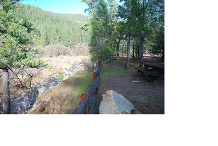
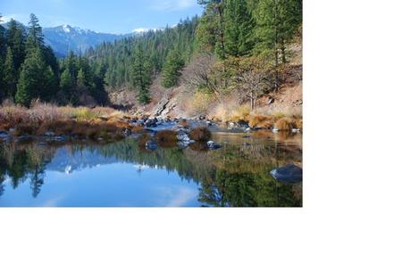
Indian Scotty Group Site is located next to the Wild and Scenic Scott River in Klamath National Forest. Visitors enjoy swimming, tubing, whitewater boating. and fishing on the river. Several trailheads for the Marble Mountains Wilderness are nearby.

Recreation

During summer, when flows in the Scott River are low, campers can fish, swim, or go tubing in the river. During the higher flows of spring, the Scott River offers class IV-V whitewater runs through the Scott River canyon. Several Marble Mountain Wilderness trailheads are easily accessed from the camground, including Boulder, Kelsey, and Lovers Camp.

Facilities

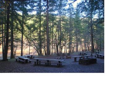
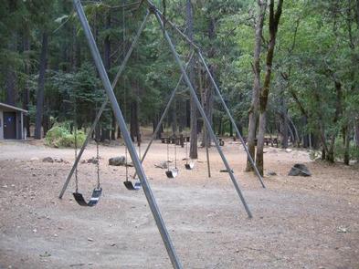
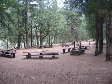
Indian Scotty is set in an open grassy area surrounded by trees. The site is particularly suited for RVs up to 30 feet in length because of its configuration. Some campsites have views of the river. A campfire circle and grill are provided. A playground is available on-site.

Natural Features

The riverside group site sits in a forest of cedar, Douglas fir and Pondarosa pine at an elevation of 2,400 feet. Mount Shasta, not part of the Klamath, is visible from some areas within the compound.

The Klamath National Forest encompasses nearly 2 million acres of land straddling the California and Oregon border. The Klamath encompasses a vast array of mountains, streams and lakes and, at elevations ranging from 450 to 8,900 feet, is home to diverse plant life and nearly 400 animal species.

Reservation

More from CampingHiking.net:

FORT SPOKANE GROUP SITE, Washington Campground Images, Info & Reservations

Directions Take State Highway 2 west of Spokane for 32 miles. Turn north on State Highway 25 at the town of Davenport and travel 24 miles. Follow the signs to the campground. Phone 509-754-7889 Activities BOATING, HISTORIC & CULTURAL SITE, CAMPING, INTERPRETIVE PROGRAMS, FISHING, HIKING, PICNICKING, VISITOR CENTER, WATER SPORTS,

PRESTON BEND, Texas Campground Images, Info & Reservations

Directions From Pottsboro, TX, travel 9 miles north on Hwy 289. Exit right at the campground. Phone 903-786-8408 Activities CAMPING Keywords PRES,TEXOMA LAKE,TEXOMA LAKE Related Link(s) Rec Area Info & Images Texas State Road Conditions Texas State Tourism Overview Preston Bend Campground is located on Lake Texoma, in the Cross

Twelvemile Beach Campground, Michigan Campground Images, Info & Reservations

Directions Phone 906-387-3700 Activities CAMPING, HIKING, BEACHCOMBING, BACKPACKING, ACCESSIBLE SWIMMING Keywords Related Link(s) Rec Area Info & Images Overview Twelvemile Beach Campground is a beautiful campground along Lake Superior located within the Pictured Rocks National Lakeshore, just 15 miles west of Grand Marais. There are 36 sites total, including 2

LOST RAPIDS, Oklahoma Campground Images, Info & Reservations

Directions From Broken Bow, OK, take Highway 3 west 22 miles to the park entrance. Turn south at the sign and follow the access road. Phone 580-876-3720 Activities BOATING, CAMPING, FISHING, PICNICKING, CANOEING Keywords LOSR,PINE CREEK LAKE,PINE CREEK LAKE Related Link(s) Rec Area Info & Images Oklahoma State Tourism Oklahoma

PHOCENA BAY CABIN, Alaska Campground Images, Info & Reservations

Directions Approximately 15 air miles and 25 water miles from Ketchikan on the south shore of Phocena Bay on the west side of Gravina Island. Accessible by floatplane or by boat. A mooring buoy is located in Phocena Bay. Refer to USGS Ketchikan A-6. Please consult local tide tables before