
Directions
From Butte, travel south on Interstate 15 for 15 miles. Take the Feely exit (no. 111) and turn west on Forest Road 96. Continue about 3 miles to Forest Road 447, turn left and travel about 2 miles to the cabin. The access road is on private land and the gate must remained closed and locked. Maps may be purchased by calling the Butte Ranger District.
Phone
406-494-2147
Activities
BIKING, CAMPING, FISHING, HIKING, HUNTING, WINTER SPORTS, WILDLIFE VIEWING
Keywords
FLEE,FLEECER STATION,FLEECER,FLEECER CABIN,BEAVERHEAD-DEERLODGE NF -FS
Related Link(s)
Overview
Fleecer Cabin is popular for hunters and hikers during the summer and fall months. It is not far from Butte, giving locals a respite from everyday life; however, a variety of recreational opportunities await every guest.
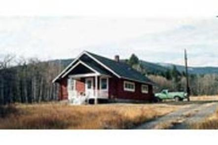
The cabin was built in 1924 and has been used as headquarters for Forest Service crews ever since. It is available between May 1st and January 3rd each year, and could be closed at any time for administrative use.
The cabin can be accessed by vehicle; however, during fall months, alternative resources may be required to reach the cabin. Guests are responsible for their own travel arrangements and safety, and must bring several of their own amenities.
Recreation
Hunting in designated areas is a popular activity, as wildlife is abundant. Fishing is also a possibility in any of the nearby mountain creeks and streams. The Big Hole River is just minutes away and is best known for its trophy-class trout fishing.
There is a variety of hiking, mountain biking and horseback riding trails that are easily accessed from the cabin into the surrounding forest. Off-road vehicles and motorcycles are also allowed in the area, but must be properly permitted and licensed to be on trails and roads. Access to the Continental Divide National Scenic Trail is located 1 mile from the cabin.
Facilities
The 3-room cabin is well-equipped, with electricity, heat and cold running water. Two bedrooms contain beds and mattresses to accommodate up to 5 people. The kitchen
provides table and chairs, an electric cook stove and refrigerator. The bathroom has a flush toilet, sink and shower with cold water only.
A variety of supplies are provided within the cabin, including dishes, eating and cooking utensils, pots and pans, a broom, dust pan and other cleaning equipment
and supplies. Ample cupboard space is available.
Guests will need to bring their own bedding, pillows, towels, and soap. Garbage bags are needed to pack out trash, and guests are asked to clean the cabin prior
to leaving. Cell phone service is minimal in the area.
Please remember that Fleece Station is considered a recreational area and shooting is not permitted around the cabin and on the surrounding private property
Natural Features
The cabin is located in the Fleecer Mountain Range approximately 15 miles south of Butte. A horse corral and grassy pasture are adjacent to the cabin.
The region is home to a variety of wildlife, including elk, mule deer, moose, black bear, and a variety of birds and small mammals (learn more about bear safety). The Fleecers provide a year-round range for elk and deer and large populations winter on nearby Fleecer Mountain or on sagebrush slopes in the southeast portion of the landscape.