WALKER CABIN, ID Campground Reservation, Info, Images, Map, Directions

WALKER CABIN, Idaho Campground Images, Info & Reservations

Directions

From State Highway 14, turn south on Crooked River Road #233 and proceed approximately 8 miles to the cabin on the right.

Phone

208-842-2245

Activities

BIKING, CAMPING, FISHING, HIKING, HUNTING, WILDLIFE VIEWING

Keywords

WALB,NEZPERCE NF – FS

Related Link(s)

Rec Area Info & Images

Idaho State Tourism

Idaho State Road Conditions

Overview

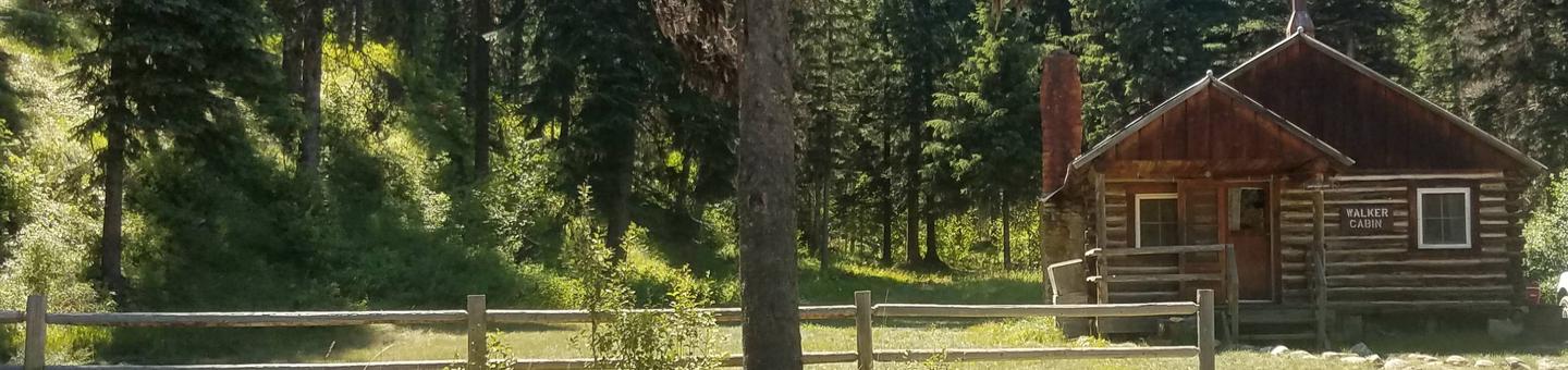
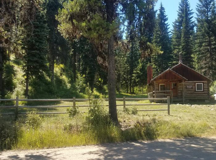
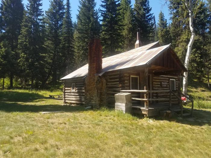
Walker Cabin is nestled among trees just off Crooked River Road #233, which leads into the Gospel-Hump Wilderness Area, in the Nez Perce National Forest.

The cabin was originally built around 1930 as a summer home. Jerry and Helen Walker purchased the cabin in 1967, then donated it to the U.S. Forest Service in the 1980s. It is now available for public recreational use. The cabin must be reserved in advanced; there are no walk-ups.

Recreation

Crooked River is a popular area for many recreational opportunities, including hiking, trout fishing, hunting, snowmobiling and cross-country skiing. A nice hiking trail is located behind the cabin.

Nearby trails lead to the Orogrande Summit, Buffalo Hump and Gospel Hump. Snowshoes may be required on the trails in winter. There are several lakes within a 3-mile radius that are easily accessible by foot or off-road vehicle.

Facilities

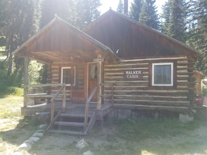
The rustic cabin has two bedrooms with two single beds each, a living room with a wood insert in the fireplace, several chairs, a table, a broom and a kitchen with a wood cook stove. A vault toilet is located in a separate building. Guests can find firewood in a shed behind the cabin.

Running water and electricity are not available. Guests should bring their own water supply and garbage bags to pack out their trash. Cookware, kitchen utensils, bedding and blankets are not provided. A lantern or flashlight and extra batteries are recommended (click here for more details about this cabin).

Natural Features

Walker Cabin sits at an elevation of 4,500 feet near the northern part of Gospel-Hump Wilderness, an area that is moist and densely forested. Big game species like elk, mule and whitetail deer, black bear, cougar, moose, mountain goat and mountain sheep live within the Wilderness. Chukar, grouse, squirrels and songbirds make their home here as well.

Nearby Attractions

The cabin is less than a mile from Orogrande, a historic mining site that is now a ghost town. The closest town, Elk City, Idaho, is a remote community with limited facilities that include a grocery store, restaurant, bar, laundromat, convenience store and gas stations.

Reservation

More from CampingHiking.net:

OAK GROVE, Arkansas Campground Images, Info & Reservations

Directions From DeQueen, AR, take Highway 71 north for 3 miles. Turn west onto DeQueen Lake Road and continue for 5.3 miles, following signs into the campground. Phone 870-584-4161 Activities BOATING, CAMPING, FISHING, HUNTING, DAY USE AREA, SWIMMING SITE Keywords OAG2,DEQUEEN LAKE,DEQUEEN LAKE Related Link(s) Rec Area Info & Images

TANIS MESA SOUTH CABIN, Alaska Campground Images, Info & Reservations

Directions The cabin is located 50 miles southeast of Yakutat between Tanis Mesa and Brabazon Mountain Range. Access is by wheeled plane only via an 1,800-ft. airstrip at the cabin. Phone (907) 784-3359 Activities CAMPING, HIKING, HUNTING, WILDLIFE VIEWING Keywords TANS,TONGASS NF – FS Related Link(s) Rec Area Info &

RIVER HILL, Colorado Campground Images, Info & Reservations

Directions From Alamosa, CO, go west on Highway 160 to South Fork. Take Highway 149 southwest through Creede and continue on Highway 149 for about 20 miles to milepost 41 (Forest Road 520) and Rio Grande Reservoir Road. Travel about 10 miles on this gravel road to the campground. Phone

LAKESIDE DAY USE, Texas Campground Images, Info & Reservations

Directions From Jefferson, Texas, travel 3.8 miles northwest on Highway 49. Turn left onto FM 729 and continue for 3.5 miles, then turn left again onto FM 726. Travel 3.5 miles the park entrance will be on the right. Phone 903-665-2336 Activities BOATING, FISHING, PICNICKING, WATER SPORTS, WILDLIFE VIEWING, DAY

PROSPECTOR, Colorado Campground Images, Info & Reservations

Directions From I-70, take the Silverthorne exit 205. Travel east on Highway 6, approximately 4 miles to Swan Mountain Road. Turn right and travel for 2 miles to Prospector and Windy Point Campground sign. Take dirt road 1 mile to campground entrance. Phone 970-468-7681 Activities BIKING, BOATING, CAMPING, FISHING, HIKING,

BIG BEND (WV), West Virginia Campground Images, Info & Reservations

Directions Follow 28/55 from Petersburg, West Virginia, for 8 miles. Turn left onto Smoke Hole Road, Route 28/11, and travel for 13 miles to County Route 2. Turn left onto the Smoke Hole Road, County Route 2, and follow for approximately 3 miles to Big Bend Campground. Phone 304-358-3253 Activities