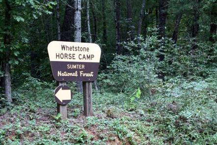
WHETSTONE HORSE CAMP, SC Campground Reservation, Info, Images, Map, Directions

WHETSTONE HORSE CAMP, South Carolina Campground Images, Info & Reservations

Directions

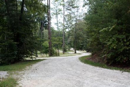
From Walhalla, go north 6 miles on State Highway 28. Turn left onto Whetstone Road. Go straight for about 5 miles. Continue straight at the four-way stop, for another 1.5 miles. The pavement ends and gravel begins. A sign for Whetstone Horse Camp is about 3/4-mile down the gravel road. The camp is on the left.

Phone

864-638-9568

Activities

CAMPING, HIKING, HORSEBACK RIDING, HORSE CAMPING

Keywords

WHET,WHETSTONE HORSE CAMP,WHETSTONE,WHETSTONE HORSE,HORSE,HORSE CAMP,CAMP,FRANCIS MARION-SUMTER NF – FS

Related Link(s)

Rec Area Info & Images

South Carolina State Tourism

South Carolina State Road Conditions

Overview

Whetstone Horse Camp is located in the Andrew Pickens Ranger District in Oconee County in the western corner of South Carolina, about 13 miles northwest of Walhalla. The Chattooga River flows nearby. With over 30 miles of horseback riding trails, Whetstone serves as a base for those who like to ride and camp.

Recreation

The Rocky Gap Trail on the South Carolina side of the river and the Willis Knob Horse Trail on the Georgia side provide excellent horseback riding and hiking opportunities. Visitors also enjoy exploring the nearby Chattooga River.

Facilities

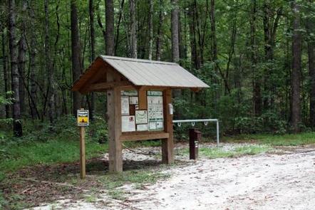
The campground is open year-round and has 18 sites with parking spurs for horse trailers. All of the 18 Sites are by reservation only.

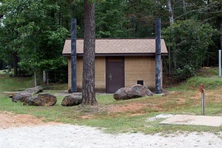
Each site is equipped with a picnic table, fire ring and lantern post. Vault toilets and drinking water are provided. Hitching racks are located throughout the facility.

Natural Features

The camp is situated in the foothills of the Blue Ridge Mountains, near the Rocky Gap and Willis Knob Horse Trails.

The Francis Marion and Sumter National Forests encompass more than 629,000 acres in four districts throughout South Carolina, from the lowcountry Atlantic Coast to the western foothills along the Georgia border.

Nearby Attractions

The town of Walhalla is 13 miles away. The town holds an annual Oktoberfest celebration the third weekend of October.

Stumphouse Tunnel, a 19-century uncompleted railroad tunnel, and Isaqueena Falls make for interesting visits. Both are located just 20 minutes from the camp.

Reservation

More from CampingHiking.net:

SINGING PINES, Georgia Campground Images, Info & Reservations

Directions From Hartwell, Georgia. follow U.S. Highway 29 east for about 6 miles and look for signs. 6001 US HWY 29 SOUTH, Starr, SC 29684 Phone 888-893-0678 HARTWELL PROJECT OFFICE Activities BOATING, FISHING, PICNICKING, DAY USE AREA, SWIMMING SITE, SWIMMING, WATER ACCESS Keywords SILP,HARTWELL LAKE PROJECT Related Link(s) Rec Area

ALEXANDER SPRINGS REC AREA, Florida Campground Images, Info & Reservations

Directions Alexander Springs Recreation Area is located along County Road 445 in the northeast corner of Lake County between Astor and Altoona, Florida. From I-75, take Highway 40 east through Ocala and Silver Springs approximately 40 miles to Highway 19. Go south on Highway 19 approximately 5 miles to Country

SIX MILE CREEK, Alabama Campground Images, Info & Reservations

Directions From Selma, Alabama, follow US-41 south for 9 miles. Turn right on County Road 139 and follow the signs into the campground. Phone 334-872-9554 Activities BOATING, CAMPING, FISHING, HUNTING Keywords SIXM,ALABAMA RIVERS,ROBERT F. HENRY,MILLERS FERRY LAKE,WILLIAM DANNELLY,ALABAMA RIV. – DAN Related Link(s) Rec Area Info & Images Alabama State

The Ledge Group Sites, Utah Campground Images, Info & Reservations

Directions From Moab, drive 10 miles on the Kane Creek Road. The group site is on the left hand side of the road. Phone 435-259-2100 Activities CAMPING, HIKING, PHOTOGRAPHY, MOUNTAIN BIKING, SCENIC DRIVE Keywords Related Link(s) Rec Area Info & Images Utah State Tourism Utah State Road Conditions Overview The

HAWKER POINT, Missouri Campground Images, Info & Reservations

Directions From Stockton, Missouri, take State Highway 39 south for 6.2 miles, turn left on Highway H and continue for 5.2 miles to the park entrance. Phone 417-276-7266 Activities BOATING, CAMPING, FISHING, VISITOR CENTER, WILDLIFE VIEWING Keywords HAWK,STOCKTON LAKE,STOCKTON LAKE Related Link(s) Rec Area Info & Images Missouri State Tourism