COTTONWOOD GROUP PICNIC SITE, WY Campground Reservation, Info, Images, Map, Directions

COTTONWOOD GROUP PICNIC SITE, Wyoming Campground Images, Info & Reservations

Listen

Directions

From Afton, Wyoming, take Highway 89 south approximately 7 miles to Smoot and watch for signs for the Cottonwood Lake Campground.

The forest boundary is about a mile up the access road, and the campground is 6 miles beyond that. Continue past the west first loop of the campground, then go right at the ‘Y’ intersection toward lake. The group picnic area is on the left side of the road.

Phone

307-886-5300

Activities

BIKING, CAMPING, HIKING, HUNTING, WILDLIFE VIEWING

Keywords

CGPS,BRIDGER-TETON NF – FS

Related Link(s)

Rec Area Info & Images

Overview

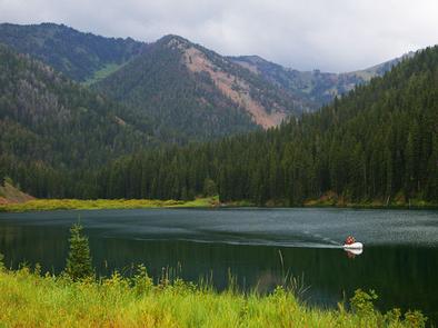
Cottonwood Group Picnic Site is located next to scenic Cottonwood Lake on the Salt River Mountains, surrounded by the forests of western Wyoming.

Recreation

The lake offers great canoeing and boating for smaller craft, as well as fishing for brook and cutthroat trout.

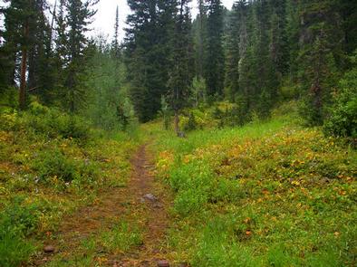
Hiking, mountain biking, off-road vehicle and horseback riding trails are in the area.

Facilities

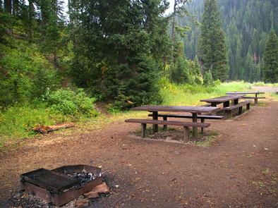
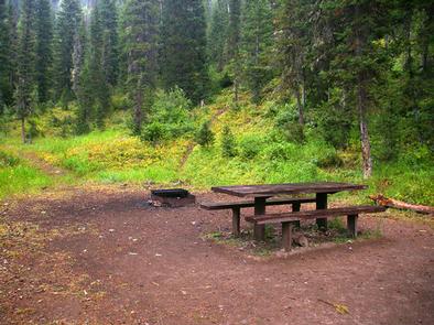
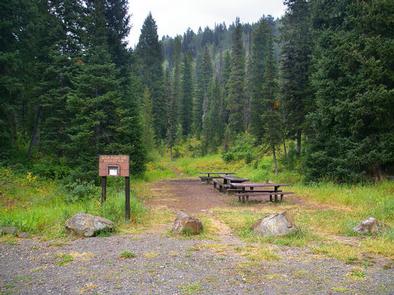
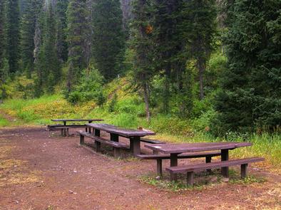
This day-use picnic site can accommodate up to 50 guests and 8-10 vehicles. Vault toilets and drinking water are provided.

A group overnight campsite is available for reservations here.

Natural Features

The picnic site is located above Cottonwood Lake, near the peaceful North Fork Creek. A forest of pines and aspens offers shade, and vibrant summer wildflowers are abundant.

The Bridger-Teton National Forest offers more than 3.4 million acres of public land for outdoor recreation. With its pristine watersheds, abundant wildlife and immense wildlands, the forest comprises a large part of the Greater Yellowstone Ecosystem, the largest intact ecosystem in the lower 48 United States.

Reservation

More from CampingHiking.net:

FALL RIVER CAMPGROUND, Oregon Campground Images, Info & Reservations

Listen Directions From Bend, OR: Travel 17.3 miles south on Hwy 97, then 12.2 miles southwest on County Road 42. Phone 541-323-1746 Activities CAMPING Keywords Related Link(s) Rec Area Info & Images Oregon State Tourism Oregon State Road Conditions Overview Fall River Campground is located along Fall River within the

WARNER LAKE, Utah Campground Images, Info & Reservations

Listen Directions From Moab, the fastest access (about 1 hour) to Warner Lake Campground is by driving south on Highway 191. Drive 6 miles south of Moab and turn east (left) onto Old Airport Road (sign has arrow to La Sal Loop Road, National Forest Access). Turn south (right) at

ELM BROOK PARK REC AREA, New Hampshire Campground Images, Info & Reservations

Listen Directions Take I-89 to exit 6 and follow the signs to Elm Brook Park. Phone 603-746-3601 Activities BOATING, CAMPING, FISHING, HIKING, WILDLIFE VIEWING, SWIMMING, MOUNTAIN BIKING, KAYAKING, CANOEING, BIRDING, NON-MOTORIZED BOATING, EDUCATIONAL PROGRAMS, SOCCER FIELDS Keywords ELBR,HOPKINTON LAKE,HOPKINTON EVERETT LAKE,ELM BROOK PARK,ELM BROOK STATE PARK,HOPKINTON – EVERET Related Link(s)

WHISKEY SPRINGS CAMPGROUND, Oregon Campground Images, Info & Reservations

Listen Directions From Butte Falls, OR, take County Rt. 821 south 9 miles to campground sign. Turn left after sign onto Forest Rt. 3065 and go 0.3 miles to another campground sign. Turn left at sign and go 0.3 miles to campground. Phone 541-560-3900 Activities CAMPING, FISHING, HIKING, VISITOR CENTER,