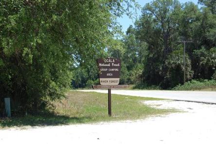
RIVER FOREST GROUP SITE, FL Campground Reservation, Info, Images, Map, Directions

RIVER FOREST GROUP SITE, Florida Campground Images, Info & Reservations

Directions

From Deland, Florida, drive west on State Route 44 to the first intersection after crossing the St. Johns River. Turn right on County Road 42, and the entrance to the campground is on the right.

Phone

352-625-2520

Activities

CAMPING, FISHING, HIKING

Keywords

RFGS,NFs IN FLORIDA – FS

Related Link(s)

Rec Area Info & Images

Florida State Road Conditions

Florida State Tourism

Overview

River Forest is a shaded group camping facility on the shores of the St. Johns River in Ocala National Forest. Located just across the river from Deland, the site is popular for groups, family reunions and weddings and can accommodate up to 125 guests.

Recreation

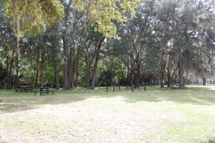
This site is a great setting for groups to relax, picnic and enjoy the shade on a warm day. A large field offers ample space for activities such as softball, volleyball and horseshoe tossing.

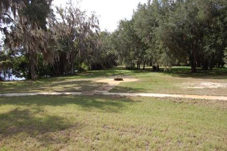
Visitors wanting to venture out of the picnic area can go for a long walk through floodplain forests and pine flatwoods on the St. Francis Trail, or head to the river to canoe, kayak or fish for bass.

Facilities

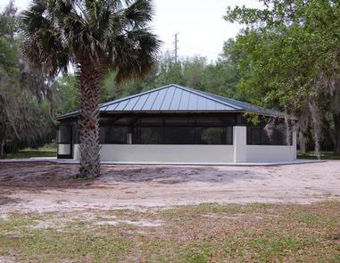
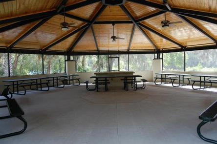
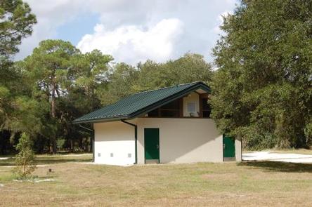
All new facilities are the highlight of the River Forest Group Site. Facilities include a screened pavilion for food preparation and cooking with your own cook stoves. A new bathhouse has also been built on site.

The camping area is flat for tents with some shade provided by trees. While RVs are welcome, there are no hookups and all vehicles must remain in the designated parking area. Grills and picnic tables are provided.

Natural Features

The Ocala National Forest spans four counties and 383,000 acres. It is the southernmost and oldest national forest east of the Mississippi River and protects the world’s largest contiguous sand pine scrub forest.

The campground is shaded with large live oaks with a flat, grassy patch of land that leads to the St. Johns River.

Nearby Attractions

The Ocala National Forest is notable for its extensive off-road trail system catering to off-road vehicle enthusiasts, as well as being a traditional destination for deer hunters from around Central Florida. Numerous lakes, rivers and natural springs surround the area and offer many water activities.

Reservation

More from CampingHiking.net:

BREVOORT LAKE CAMPGROUND, Michigan Campground Images, Info & Reservations

Directions N4149 Brevort Camp Road Moran Michigan 49760 From St. Ignace, Michigan, take Highway 2 west for about 20 miles. Turn north on Brevort Camp Road/Forest Service Road 3108, then right at Forest Service Road 3473 and continue to the campground entrance. Phone 906-203-9872 Activities BIKING, BOATING, CAMPING, FISHING, HIKING,

WHITE RIVER, California Campground Images, Info & Reservations

Directions From Highway 99, turn east onto J22. Proceed on J22 through California Hot Springs to the "T" intersection. Turn right at intersection M56 through Pineflat. Go 3 miles on the gravel road and turn directly across the bridge. The entrance is a quarter-mile past the bridge on the right

Dillon Lake Group Picnic Shelter, Ohio Campground Images, Info & Reservations

Directions The facility is located along Route 146, approximately 7 miles north of Zanesville, Ohio. You can access Route 146 by either State Route 16 from the north, or by US 70 from the south. Phone 740-454-2225 Activities BIKING, BOATING, HISTORIC & CULTURAL SITE, CAMPING, INTERPRETIVE PROGRAMS, HUNTING, WINTER SPORTS,

CAYUSE HORSE CAMP, Washington Campground Images, Info & Reservations

Directions From Cle Elum, Washington, take State Hwy 903 north approximately 19 miles to the end of the paved road. The campground entrance is to the right before the Old Guard Station. Phone 509-852-1100 Activities CAMPING, HIKING, HORSEBACK RIDING, PHOTOGRAPHY, HORSE CAMPING, BERRY PICKING, BIRDING Keywords CAYH,OKANOGAN – WENATCHEE NF

PERRY SOUTH CAMPGROUND, Oregon Campground Images, Info & Reservations

Directions From Sisters, travel 5.6 miles northwest on Hwy 20. Continue 20.8 miles north on Forest Road 11, then 5.0 miles east on Forest Road 1170, and then 2.6 miles northwest of Forest Road 64. Phone 503-464-8515 Activities BIKING, BOATING, CAMPING, FISHING, HIKING, WATER SPORTS, WILDLIFE VIEWING, DAY USE AREA,