

Directions
From Potter Valley, turn right on Eel River Road (North County Road 240B) and drive 4 miles to the Y-intersection. Take the right hand fork of the Y, signed as Cutoff Road, and travel down the hill for about a half-mile. At the bottom of the hill proceed north on County Road 240B and cross the Eel river bridge. Proceed to the right towards Lake Pillsbury for 14 miles, to the junction of M1 (Soda Creek Store). Proceed to the right (south) on M1 to the Eel River and again cross the Eel River. At the junction of M1 and M8 proceed left to stay on M1.
After approx 6 miles turn right onto the 18N05 follow signs for Pine Mountain Lookout. After a few miles when reaching a hairpin turn, turn left onto the 17N23. A gate will be on the right a few miles down as well as a sign for the lookout.
Phone
707-275-2361
Activities
HISTORIC & CULTURAL SITE, CAMPING, HIKING, HUNTING, WILDLIFE VIEWING, FIRE LOOKOUTS/CABINS OVERNIGHT, BIRDING
Keywords
PINM,MENDOCINO NF – FS
Related Link(s)
California State Road Conditions
Overview
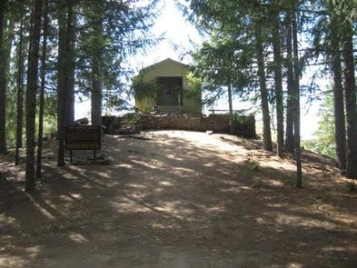
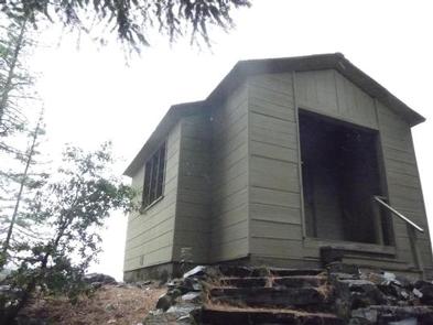
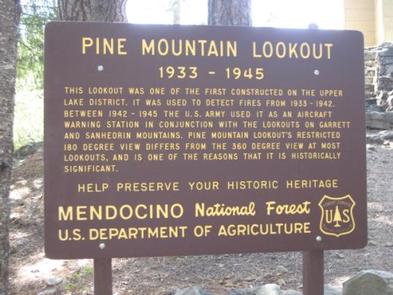
Rustic Pine Mountain Lookout was constructed in 1933 and used for fire detection until 1942. During World War II, the lookout served as part of an aircraft defense monitoring system that extended throughout California. This lookout is historically significant because it only offers 180-degree views of the surrounding terrain, while other lookouts have 360-degree views. The lookout is typically open from May through October and is accessible by car. Guests are responsible for their own travel arrangements and safety, and will need to bring several of their own supplies for a comfortable and enjoyable experience at the lookout.
Recreation
The lookout mostly offers a prime location for relaxing and enjoying the views. Guests craving more active pursuits can find hiking trails and hunting areas nearby. Floating and fishing on the Eel River are popular pastimes enjoyed by visitors to the area.
Facilities
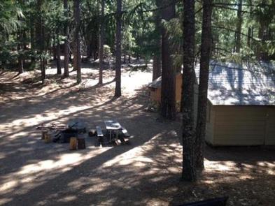
The inside of the cabin is equipped with a set of bunk beds and four cots, touch lights, a dining table with chairs and storage cabinets. A fire extinguisher and first aid kit are provided for emergency use. A picnic table, fire ring and grill are located outside. An outhouse with a vault toilet is a short distance away. There is no water and electricity. Guests must bring their own water supply, as well as trash bags to pack out their trash. The bunk bed does not have box springs or mattresses. Items such as bedding, lanterns or flashlights, firewood, cookware, utensils and extra toilet paper are not provided.
Natural Features
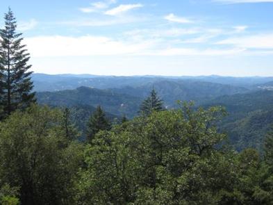
The lookout is perched on an outcropping, at an elevation of 4,400 feet. It is in a mixed forest of ponderosa pine, Douglas fir, black oak and madrone trees. Bucknell Creek and the Eel River are the major drainages in the area. The windows afford views of endless mountain peaks and offer a good vantage point for watching the evening sunsets. A variety of bird species inhabit the forest, and guests may spot eagles, owls, hawks and osprey. Mountain lions, black bears, black-tailed deer, flying squirrels, bobcats and Tule elk also live in the area. Please be safe around snakes and bears.
Nearby Attractions
The historic town of Upper Lake is approximately 19 miles to the south. This former logging and ranching town offers excellent bird watching, various recreational activities, shops, restaurants and events. The Lake Pillsbury recreation area is seven miles to the northeast. This is the largest lake in Mendocino National Forest and offers many recreational opportunities.