
Directions
Drive east from Butte Falls on the Butte Falls-Fish Lake Highway (County Road #821) for approximately 19 miles to the junction with State Highway #140. Turn right, go .08 miles on Highway #140 to the junction with Forest Service Road #37. Turn left, and travel approximately 4 miles to the junction with the guard station driveway. The station is visible on the left from this location. Turn left, travel through the gate to the guard station. From White City, OR, for an alternative route to Big Elk Guard Station that bypasses the town of Butte Falls, take State Highway 140 traveling east to the Junction with Forest Road 37, or take State Highway 140 traveling west from Klamath Falls, OR to the Junction with Forest Road 37. Turning onto Forest Road 37 traveling south, follow directions as above to the guard station.
Phone
541-865-2700
Activities
CAMPING, HIKING
Keywords
None
Related Link(s)
Overview
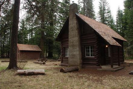
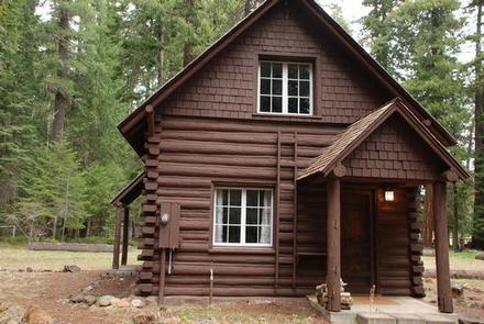
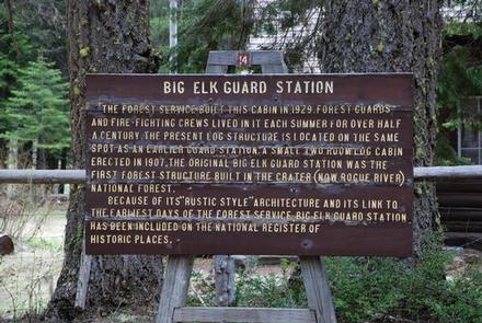
With a history that dates back to 1907, Big Elk Guard Station is the oldest continuously used administrative site within the Rogue River-Siskiyou National Forest, and a delightful setting for guests seeking a comfortable and unique getaway. For many decades the guard station served as summer headquarters for solitary forest “guards” who built trails, fought forest fires and patrolled the land on horseback. Most recently the site was used to house Forest Service seasonal fire crews. The cabin is one of the few remaining examples of Forest Service log construction in the Forest and is listed on the National Register of Historic Places.
Recreation
Hiking opportunities abound in the area, including the Pacific Crest National Scenic Trail to the south and west of Brown Mountain. The Brown Mountain Trail is also nearby, crossing through the Brown Mountain lava flows located between Fish Lake Campground and Lake of the Woods.
Additional opportunities for fishing, hiking, mountain biking, cross country skiing and snowmobiling exist closer to the highly developed recreation areas around Howard Prairie Lake and Fish Lake Resorts. Both resorts have a restaurant, boats for rent and camping.
Facilities
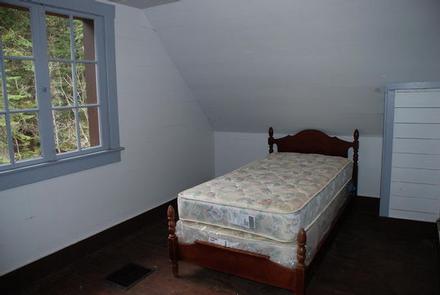
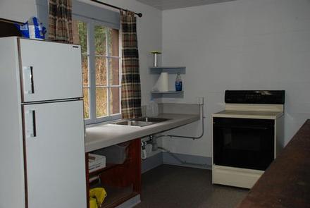
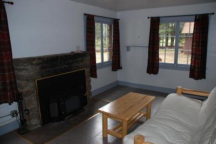
Big Elk Guard Station is a rustic log cabin with a main room and a kitchen on the ground floor and two upper-story bunkrooms, reached by a double landing stairway. The first floor rooms include a large, comfortable living room with a mortared-rock fireplace and a well-equipped kitchen with a table and chairs, a dry sink, and an electric range and refrigerator.
The original fir flooring remains intact. There are electric lights and heat throughout the cabin. Firewood is provided on site for indoor use only. There are no guarantees of firewood. The supply may run low and what is there may have to be split by the visitor with the tools provided. No drinking water is provided. Visitors must bring plenty of their own water for drinking, cooking and washing. Water can be obtained at the North Fork Campground approximately 1 mile north on Forest Service Road #37.
A picnic table and fire ring are available for outdoor dining, and an outbuilding, built by the Civilian Conservation Corps, acts as a storage shed for firewood. A vault toilet is located near the cabin, as well as additional space for tent camping.
Natural Features
Big Elk Guard Station sits on the fringe of Big Elk Meadow, a grassy expanse that floods as a shallow in spring and dries out in the summer, providing excellent grazing grounds for a dozen or more horses.
Just a short stroll across the meadow, guests are treated to views of Mt. McLoughlin and the edge of a 20,000 year old lava flow from Brown Mountain. The surrounding forest, which includes lodgepole pine, quaking aspen, Shasta red fir and Douglas fir, add to the incredible beauty of the site.
A variety of wildlife ranging from blacktail deer, elk, mountain lion, black bear, bald eagle and other bird species can be found in the area.
Nearby Attractions
Visit Crater Lake National Park and learn about its unique natural and cultural history. At a depth of 1,943 feet, Crater Lake is the deepest lake in the United States and one of the ten deepest lakes in the world.
Experience 172 miles of diverse river and mountain landscapes along the Rogue-Umpqua National Scenic Byway. Travel from rolling oak-covered hills and towering coniferous forests, to roaring white water rapids and incised inter-canyon lava flows. The highway travels alongside the Upper Rogue and North Umpqua Wild and Scenic Rivers that contain world-class fisheries.