
Directions
Crandall Creek Cabin is located approximately 24 miles northeast of Wilsall, and 52 miles from Livingston. From Livingston, travel north on Highway 89 to Wilsall. Turn right from Highway 89 onto Shields River Road. Follow Shields River Road until the pavement ends and turn right at the end of the pavement. Travel approximately 7 miles to a fork in the road, and take the left fork towards the Shields River Camp (approximately 2 miles to the camp). About 100 yards beyond the campground, take a left onto a gated road. The cabin combination code will open the gate. The cabin is located 200 yards down this road. Due to road conditions, a high-clearance, four-wheel drive vehicle is suggested. From Dec. 2 through March 31, the last seven miles of the access road to Crandall Cabin are not plowed. Plan to ski, snowshoe or snowmobile this distance from the end of the plowed road to the cabin. It is recommended that winter renters carry topographic maps and compasses for navigation, since the route maybe wind-blown and difficult to find. Signs may be down due to weather conditions or vandalism.
Phone
406-222-1892
Activities
CAMPING, FISHING, HIKING, WINTER SPORTS, WILDLIFE VIEWING
Keywords
BENNETT CREEK CABIN
Related Link(s)
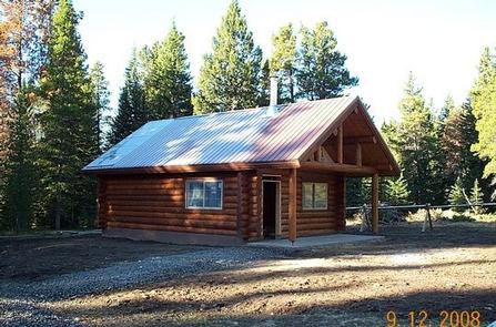
Overview
A historic cabin known as Bennett Creek Cabin was located over a mile from this site, but it was recently replaced with the current Crandall Creek Cabin, a traditional log structure. This cabin offers rustic accommodations with limited amenities, so guests should be prepared to bring most of the supplies and gear they need for a comfortable stay. Access to the cabin is via a semi-primitive dirt road. Four-wheel drive is suggested on this road from June 16 to Dec. 1. Guests who arrive after Dec. 1 must get to the cabin by hiking, snowshoeing, skiing or snowmobiling seven miles from the end of the plowed road to the cabin. No off-road vehicles or motorcycles are allowed beyond the Shields River Loop gate from Dec. 2 to June 15. Guests are responsible for their own travel arrangements and safety.
Recreation
Activities in the area include hiking, mountain biking, birding, hunting, horseback riding and during the summer months, ATV’s and motorcycles may be used on the main roads if street legal. Winter activities include snowshoeing, snowmobiling and cross-country skiing. Excellent fishing is available in the nearby creeks. Hunting is also a popular pastime in this area each fall.
Facilities
The cabin can sleep up to six people, in three available bunk beds with mattresses. A table with benches, a wood stove for heat and a propane lantern are provided. There is a mop and bucket for cleaning the cabin. FIREWOOD IS NOT AVAILABLE FROM JUNE 1ST THROUGH SEPTEMBER 30TH. PLEASE BRING FIREWOOD OR GATHER FROM FOREST DURING SUMMER. DO NOT BURN PROVIDED FIREWOOD FOR OUTDOOR FIRES,EVER, AS IT IS EXTREMELY DIFFICULT TO REPLACE. Firewood is available during winter months as long as supplies last. An axe and splitting maul are also supplied. Both the cabin and adjacent vault toilet are wheelchair accessible. There is a campfire ring and picnic table outside. No water, electricity or propane canisters for the lantern are provided. Guests need to provide their own water supply as well as bring propane canisters or battery-operated lanterns or flashlights. Cooking facilities are not provided. A table is available to set up a propane camp stove. Guests need to bring bedding, matches, toilet paper, first aid kit, cookware, dishes, utensils and newspaper for a comfortable stay. A stock corral is provided for four animals. If the corral is used for stock, it must be cleaned before leaving. Feed must be Certified Weed Seed Free and out-of-state horses must have a current Coggins test. Water for the horses can be obtained from a creek nearby.
Natural Features
Crandall Creek Cabin is tucked beneath the foothills of the Crazy Mountains. The front porch of the cabin offers a majestic view of Target Rock and spectacular star gazing on a clear night.
The cabin is situated at an elevation of approximately 6,400 feet, near several creeks and the Shields River. This area is home to bears, elk, deer and moose, among other wildlife species. Birders may spot a variety of birds.