DILLON CREEK CAMPGROUND, CA Campground Reservation, Info, Images, Map, Directions

DILLON CREEK CAMPGROUND, California Campground Images, Info & Reservations

Directions

From State Route 299 in Willow Creek, take State Route 96 north for 60.2 miles. The campground will be on the left side.

From Interstate 5 in northern California, take State Route 96 southwest, past Happy Camp, for 85.7 miles. The campground will be on the right side.

Phone

530-629-4136

Activities

BOATING, CAMPING, FISHING, HIKING, WILDLIFE VIEWING

Keywords

DILLON CREEK CAMPGROUND (CA)

Related Link(s)

Rec Area Info & Images

California State Road Conditions

California State Tourism

Overview

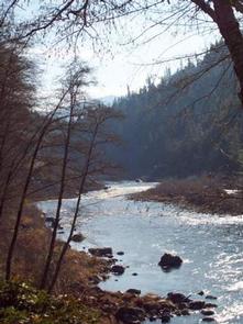
Dillon Creek Campground sits along its namesake creek in the lush forests of northern California. Visitors enjoy a variety of water sports on the nearby Klamath River.

Recreation

The Klamath and Salmon Rivers offer excellent fishing, swimming and whitewater rafting opportunities. Fishing for salmon and steelhead during the fall and early winter months is considered the finest in California. Hunting is also a popular pastime, with game including blacktail deer, black bear, blue grouse and quail.

Facilities

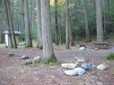
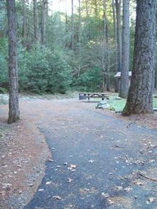
This campground has several single-family campsites, all equipped with picnic tables and campfire rings with grills. Vault toilets and drinking water are provided. A host may be on-site, and roads throughout the campground are paved.

Natural Features

The campground is situated in a forest of mixed hardwoods and conifers at an elevation of 1,780 feet. The Klamath River, a popular site for salmon fishing, runs alongside the site.

Reservation

More from CampingHiking.net:

SUMMERDALE CAMPGROUND, California Campground Images, Info & Reservations

Directions Take Highway 41 north from Fresno, just past the town of Fish Camp. The campground is on the left side of the highway, 1.5 miles before the entrance to Yosemite National Park. Phone 559-642-3212 Activities CAMPING, FISHING, HIKING Keywords SUMD,SUMMER WIND,FISH CAMP,SIERRA NF – FS Related Link(s) Rec Area

GROOM CREEK SCHOOLHOUSE, Arizona Campground Images, Info & Reservations

Directions From Phoenix, Arizona, take I-17 north for 61.8 miles. Take exit 262 toward Cordes Junction/Prescott. Merge onto State Route 69 west and follow for 33.8 miles. At the split, take the ramp for Route 89 south. Turn slight left onto East Gurley Street/89 and follow for about 0.8-mile. Turn

HAWKER POINT, Missouri Campground Images, Info & Reservations

Directions From Stockton, Missouri, take State Highway 39 south for 6.2 miles, turn left on Highway H and continue for 5.2 miles to the park entrance. Phone 417-276-7266 Activities BOATING, CAMPING, FISHING, VISITOR CENTER, WILDLIFE VIEWING Keywords HAWK,STOCKTON LAKE,STOCKTON LAKE Related Link(s) Rec Area Info & Images Missouri State Tourism

CAVE SPRING, Arizona Campground Images, Info & Reservations

Directions From Phoenix, take I-17 to Highway 179 north toward Sedona. Turn north on Highway 89A and continue for 11 miles into Oak Creek Canyon. From Flagstaff, take I-17 to Highway 89A south. Follow 89A for 18 miles to Oak Creek Canyon. Phone 928-282-1629 Activities CAMPING, FISHING, HIKING, WILDLIFE VIEWING,

RUEDI MARINA CAMPGROUND, Colorado Campground Images, Info & Reservations

Directions Take I-70 west of Denver to Glenwood Springs Exit 116, Highway 82 to Basalt. At Basalt, take Frying Pan Road 15 miles to the Ruedi Complex Entrance. Phone 970-927-0107 Activities BIKING, CAMPING, INTERPRETIVE PROGRAMS, FISHING, HIKING, WATER SPORTS, WILDLIFE VIEWING Keywords Related Link(s) Rec Area Info & Images Forest

KALALOCH, Washington Campground Images, Info & Reservations

Directions Kalaloch Campground is on Highway 101, 34 miles south of Forks, Washington, and 73 miles north of Aberdeen, Washington. Phone 360-565-3130 Activities CAMPING, HIKING, VISITOR CENTER, WILDLIFE VIEWING Keywords Clay-lock,Clay Lock,Olympic National Park Related Link(s) Rec Area Info & Images Washington State Tourism Washington State Road Conditions Overview Kalaloch