FAIRVIEW RANGER STATION, MT Campground Reservation, Info, Images, Map, Directions

FAIRVIEW RANGER STATION, Montana Campground Images, Info & Reservations

Directions

From Libby Montana follow Hwy 37 N for 14 miles to Fisher River Road 763. Turn right and follow for 10 miles; continue straight merging onto Wolf Cr/Fortine Cr road 36 and follow for another 17 miles. The cabin will be on the left.

Phone

406-293-7773

Activities

CAMPING, FISHING, HIKING, HUNTING, WILDLIFE VIEWING

Keywords

FAIRVIEW RANGER STATION

Related Link(s)

Rec Area Info & Images

Montana State Tourism

Montana State Road Conditions

Overview

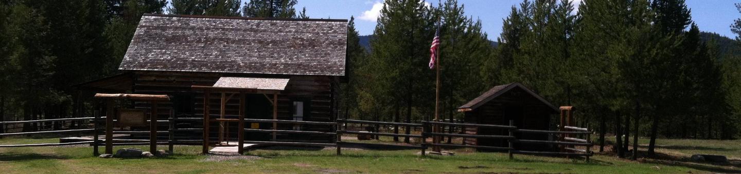
This remote cabin was built in 1908 and served as an administration building for the Wolf Creek District of the Blackfeet National Forest. The Blackfeet NF was dissolved in 1935 becoming part of the Kootenai & Flathead NF. Fairview was used as a remote work station until 1980. In 2011 major work was done to restore the cabin and put it on the rental system. The cabin is open year-round and is accessible by car.

Recreation

Opportunities abound from this location. Hiking, fishing, floating, hunting, scenic and historical driving tours are just some of the activities to be enjoyed.

Facilities

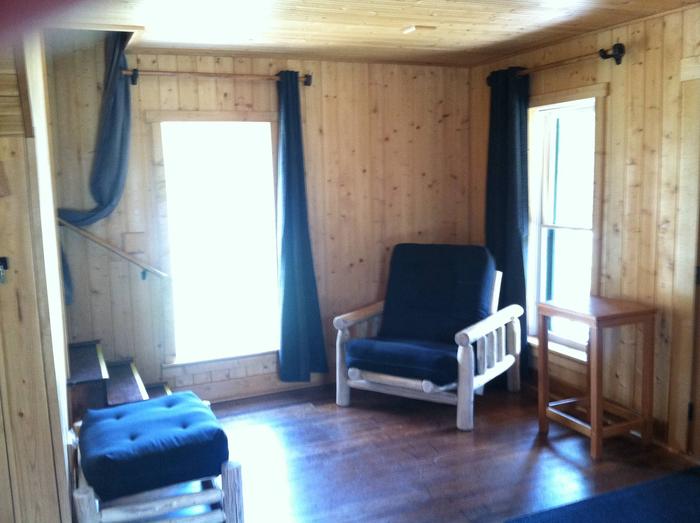
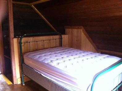
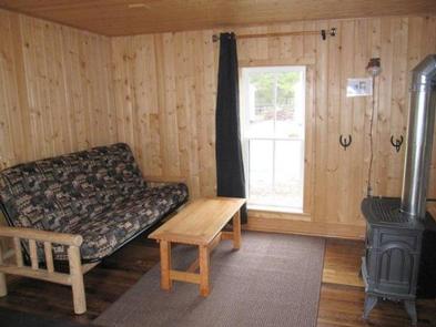
This 900 square foot cabin can sleep up to 6 people and comes furnished with one double bed and two twin beds with mattresses upstairs and one double futon and twin futon with mattresses downstairs.

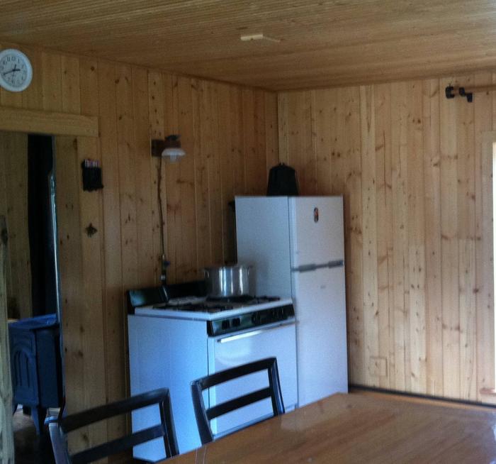
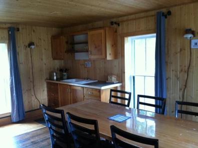
Other amenities include a propane stove, refrigerator, heater and lights, table and chairs, table settings for eight, kitchen tools, pots and pans and cleaning gear. A vault toilet is located nearby.

Electricity and potable water are not available. Guests must bring enough water for drinking, cooking and washing. Items such as bedding, lanterns or flashlights, matches, first aid supplies, garbage bags, dish soap, dish towels and dish cloths are not available. Guests are expected to pack out all trash and clean the cabin before leaving.

Natural Features

The Fairview Ranger Station is situated near Wolf Creek at an elevation of 2,995 feet within the Salish Mountain Range of the Rocky Mountains in the Kootenai National Forest. Wolf Creek and its many tributaries provide habitat for a variety of trout and big game animals. Wolf Creek has been an important route through history as a trail for the Kootenai Indians, early prospectors and railroads.

Reservation

More from CampingHiking.net:

FORKS OF HUNTINGTON, Utah Campground Images, Info & Reservations

Directions The campground is 16 miles west of Huntington, Utah, along Highway 31. Phone (435)384-2372 Activities BIKING, CLIMBING, CAMPING, FISHING, HIKING, WILDLIFE VIEWING Keywords FORH,MANTI-LASAL NF -FS Related Link(s) Rec Area Info & Images Utah State Tourism Utah State Road Conditions Overview Forks of Huntington Campground is located in beautiful

UPPER ARCADIA, Arizona Campground Images, Info & Reservations

Directions From Safford, Arizona: Take State Route 191 south for 6 miles. Turn right onto State Route 366/Swift Trail and travel 11.5 miles to the Arcadia Campground entrance (MM 125.5), taking the next right turn to access Upper Arcadia.  From Tucson, Arizona: Take I-10 East for 90 miles. Take exit

SOUTH DICKEY LAKE, Montana Campground Images, Info & Reservations

Directions From Eureka travel South on Hwy 93 for approximately 20 miles. Take a left on Lake Shore road 3788 and follow for 2 miles to the day use site. Phone 406-296-2536 Activities BOATING, CAMPING, FISHING, SWIMMING SITE Keywords SODI,SOUTH,DICKEY,LAKE,KOOTENAI NF – FS Related Link(s) Rec Area Info & Images

PRAIRIE FLOWER RECREATION AREA, Iowa Campground Images, Info & Reservations

Directions From I-35, take exit 90 to Ankeny/Oralabor Road and go west for 4.8 miles. The road turns into Highway 415, continue and follow signs to the campground. Phone 515-984-6925 Activities BIKING, BOATING, CAMPING, FISHING, HIKING, HUNTING, WATER SPORTS, SWIMMING SITE Keywords PRAF,SAYLORVILLE LAKE,PRAIRIE FLOWER NORTH,PRAIRIE FLOWER SOUTH,ASTER,BLAZINGSTAR,CONEFLOWER,DOGBANE,ELDERBERRY,FLEABANE,GOLDENROD,HONEYSUCKLE,IRONWEED,JUNEBERRY,KNAPWEED,LEADPLANT,MAYWEED,NIPPLEWORT,OXEYE,SAYLORVILLE LAKE Related

RIVER FOREST GROUP SITE, Florida Campground Images, Info & Reservations

Directions From Deland, Florida, drive west on State Route 44 to the first intersection after crossing the St. Johns River. Turn right on County Road 42, and the entrance to the campground is on the right. Phone 352-625-2520 Activities CAMPING, FISHING, HIKING Keywords RFGS,NFs IN FLORIDA – FS Related Link(s)