OFF COW CAMP CABIN, CO Campground Reservation, Info, Images, Map, Directions

OFF COW CAMP CABIN, Colorado Campground Images, Info & Reservations

Directions

Access is from the upper or lower Burro Creek Trailheads (trail #873). From the west side of the town of Del Norte, head south on County Road 14 for 12 miles to the lower Burro Creek Trailhead. The cabin is 6 miles upstream from this trailhead and 1.5 miles from the upper trailhead. The upper trailhead is located 28 miles from the town of Del Norte and is accessed by Forest Service Roads 329 and 329.1C.

Phone

719-657-3321

Activities

BIKING, CAMPING, FISHING, HIKING, HUNTING, WINTER SPORTS

Keywords

OFF COW CAMP

Related Link(s)

Rec Area Info & Images

Colorado State Road Conditions

Colorado State Tourism

Overview

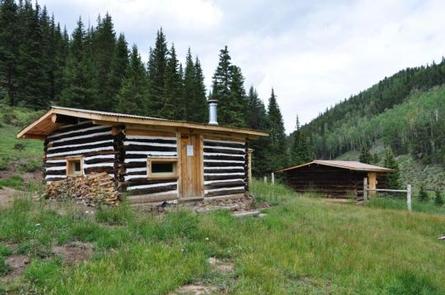
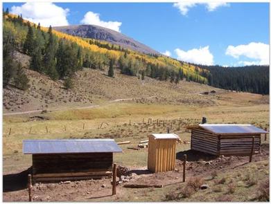
Off Cow Camp is a small cabin located in a high elevation meadow at 10,500 feet on Burro Creek near an off-highway vehicle trail. The cabin and barn were renovated in 2010 and a vault toilet was installed. Visitors may reserve the cabin for a maximum of fourteen nights to allow others the opportunity to rent the cabin.

Recreation

The surrounding area offers many recreation opportunities, including hunting, hiking, off-highway vehicle riding, horseback riding, mountain biking, snowmobiling, backcountry skiing, and fishing.

Facilities

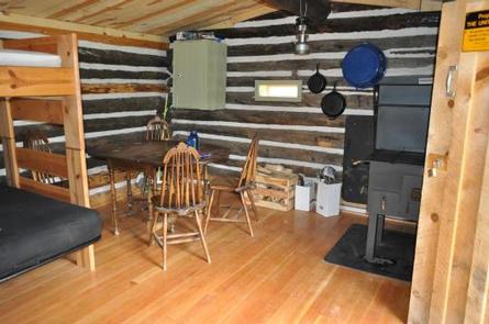
The small, rustic cabin sleeps four (two bunk beds). There is a wood burning cook stove, outhouse, barn for horses, fire ring, table and chairs. There is no potable water. Natural sources of water should be treated before use. Firewood not provided. Firewood can be gathered near the cabin.

Natural Features

There are meadows, aspen groves and spruce/fir forests near the cabin. At 13, 200 feet, Bennett Peak sits southeast of the cabin. Fitton Guard Station is located 400 yards upstream from Off Cow Camp and is available as a rental cabin to the public.

Nearby Attractions

The Burro Creek off-highway vehicle (OHV) trails connect many miles of OHV trails and forest roads in the area. The trails are also used by motorcycles, mountain bikers, hikers and horseback riders. During the winter, snowmobilers and backcountry skiers use the area near the cabin.

Reservation

More from CampingHiking.net:

ANAN LAKE CABIN, Alaska Campground Images, Info & Reservations

Directions The cabin is on the south end of Anan Lake, which is on the mainland (231′ elevation) above Anan Bay. This cabin is accessible by float plane only, and is 31 miles by air from Wrangell. The lake is normally ice-free May through October. At other times, ice may

ANTELOPE, Idaho Campground Images, Info & Reservations

Directions From Horseshoe Bend, Idaho, take State Highway 52 for 9 miles, then turn right on Sweet/Ola Highway and travel 16 miles to Ola. From Ola, continue 10 miles northeast on FS Rd 618, then make a right on FS Rd 626 and follow it for 7 miles. Make a

ROBIE CREEK PARK GROUP SHELTER, Idaho Campground Images, Info & Reservations

Directions From the intersection of Warm Springs Road and Highway 21, turn onto northbound Highway 21 towards Idaho City. Continue straight along Highway 21 for 9.2 miles, passing by Lucky Peak Dam and the Forest Service Nursery. Continue straight after crossing the Mores Creek "High Bridge" another 2.3 miles. Approximately

SURVEYORS LOOKOUT, Idaho Campground Images, Info & Reservations

Directions From the St. Joe River Road (FH50) to Beaver Creek, drive 29 miles east of Avery to the junction of the Red Ives Road 218. Turn south (right) and drive 8 miles to the junction of Beaver Creek Road 303 (just past Beaver Creek Campground). Drive about 7.5 miles

JUNIPER LAKE GROUP, California Campground Images, Info & Reservations

Directions From the Red Bluff (I.5), drive east on state HWY 36 approximately 70 miles to Chester. Turn left at fire station immediately after crossing Feather River Bridge (watch for National Park Service sign on right) continue approximately 13 miles follow signs to Juniper Lake Campground and Group Campsite Area.