Sand Island Group Sites, UT Campground Reservation, Info, Images, Map, Directions

Sand Island Group Sites, Utah Campground Images, Info & Reservations

Directions

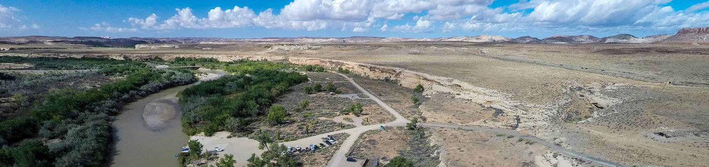
Sand Island Campground is located on the north bank of the San Juan River about 3 miles west of Bluff, Utah, on the south side of Highway 191.

Phone

435-587-1500

Activities

HISTORIC & CULTURAL SITE, CAMPING, PICNICKING, PHOTOGRAPHY, PADDLING, WATER ACCESS, WHITEWATER RAFTING

Keywords

None

Related Link(s)

Rec Area Info & Images

Utah State Road Conditions

Utah State Tourism

Overview

Sand Island Campgrounds two group campsites are ideal for groups wishing to be close to the town of Bluff and the San Juan River. The area offers outdoor enthusiasts many options for river floating, scenic driving and rock art viewing.

Recreation

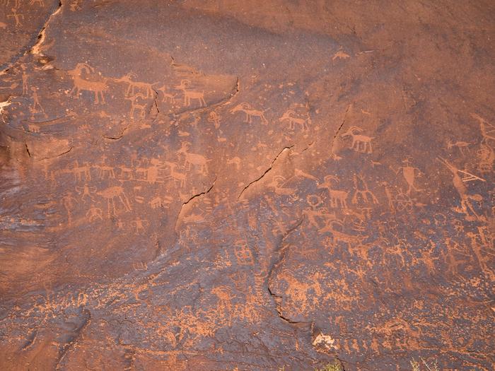
Sand Island is the main put-in for the 102-mile section of the San Juan River between Montezuma Creek and Clay Hills Crossing that provides boaters with access to spectacular canyons rich in scenery, geology, archeology, history and wildlife. Within the campground there are numerous petroglyphs and pictographs on the ledges above and it is a popular destination for both sightseeing and bird watching.

Facilities

Group Site A is located near the boat ramp and features picnic tables, a fire grate, a shade structure and has water nearby. The site may be reserved in advance for groups of 10 to 20 people for a maximum of fourteen days. Group Site B can accommodate group sizes from 15 to 40 people and is located in Loop B of the campground and features picnic tables, a large fire grate, a shade structure, water on site and a single vault toilet. The group sites do not have dump stations or electric hook ups. There are dumpsters located at the campground entrance.

Natural Features

Sand Island Campground is beside the San Juan River.

Nearby Attractions

Sand Island is close to Goosenecks State Park, Bears Ears National Monument (Shash Jaa Unit), and Cedar Mesa.

Reservation

More from CampingHiking.net:

OH RIDGE, California Campground Images, Info & Reservations

Directions Oh Ridge Campground is 350 miles north of Los Angeles and 150 miles south of Reno, Nevada. Take U.S. Highway 395 to its southern junction with Highway 158. Take 158 for 1 mile. Turn right on North Shore Drive. Go approximately 1 mile and turn left on Pine Cliff

SHAWNEE BEND, Missouri Campground Images, Info & Reservations

Directions From Highway 7, travel north on the Dam Access Road for 3 miles and follow signs into the park. Phone 660-438-7317 Activities BOATING, CAMPING, FISHING, SWIMMING SITE Keywords SHAW,TRUMAN LAKE,HARRY S TRUMAN Related Link(s) Rec Area Info & Images Missouri State Tourism Missouri State Road Conditions Overview Shawnee Bend

OZARK PAVILION, Arkansas Campground Images, Info & Reservations

Directions From Harrison, head south on Highway 7 for approximately 13 miles. After driving over a bridge over the Buffalo River, look for a brown sign for the Ozark Campground. Turn right onto the gravel road and follow it for about one mile to the campground and pavilion. Phone 870-861-2570

WAVELAND PARK, Arkansas Campground Images, Info & Reservations

Directions From Booneville, Arkansas, follow State Highway 10 east for 17 miles to Waveland. Turn right on State Highway 309 and drive for one mile. Turn right again onto Waveland Park Road and continue another mile to Blue Mountain Dam, then follow signs into the park. Phone 479-947-2101 Activities BOATING,