SARDINE PEAK LOOKOUT, CA Campground Reservation, Info, Images, Map, Directions

SARDINE PEAK LOOKOUT, California Campground Images, Info & Reservations

Directions

From the Sierraville Ranger District Office, proceed south on Highway 89 for 12 miles to Sierra County Road S450. Turn left onto road S450 and proceed east for 4 miles to Sierra County Road S650, the Lemon Canyon Road. Turn left onto County Road S650 and proceed north for 2 miles to Forest Service Road 650-75, the Sardine Peak Lookout Road and proceed 4 miles to the locked gate. Sardine Peak Lookout is about 250 yards beyond the locked gate.

Phone

(530) 994-3401

Activities

HISTORIC & CULTURAL SITE, CAMPING

Keywords

Related Link(s)

Rec Area Info & Images

California State Road Conditions

California State Tourism

Overview

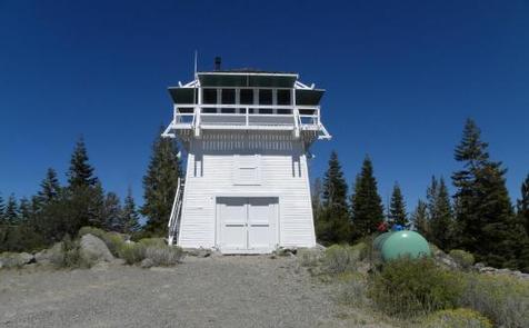
Sardine Peak is a forest fire lookout tower that was constructed in 1935 by the Civilian Conservation Corps. It is a three story enclosed tower with external stairs. Presently the top room or observation cab is the only rentable space. Sardine sits at an elevation of 8,138 feet in the Eastern Sierra Nevada Mountains of Tahoe National Forest, approximately 20 miles from Truckee, California. The lookout does not have electricity, water or garbage service. It does have a propane tank to operate propane-powered appliances.

Recreation

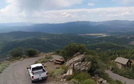
Hiking, mountain biking and off road vehicle use are popular around this lookout. Stampede and Boca Reservoirs are nearby for fishing, boating and swimming.

Facilities

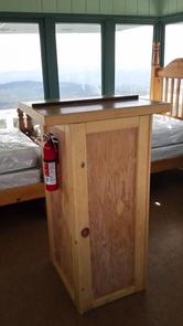
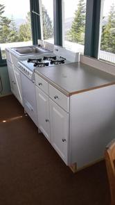
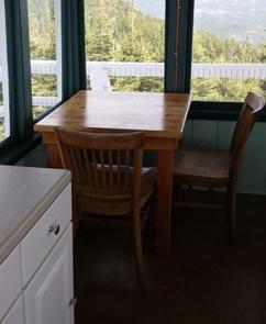
The interior of the cab is 14 feet long and 14 feet wide and contains two twin beds, a dry sink, a table and four chairs, three propane lights, a propane cast iron heat stove and a propane stove/oven for cooking. A limited assortment of cooking utensils, pots and pans are provided. There is an accessible vault toilet, a picnic table and fire ring are located outside below the lookout. Firewood is not provided. Visitors need to bring their own bedding, toilet paper and other personal items.

Natural Features

The lookout tower sits on a mountain top with spectacular views of Stampede Reservoir, Boca Reservoir, Sardine Valley, Independence Lake, the top of the Sierra Buttes and western Nevada.

Nearby Attractions

Kyburz Flat Interpretive Area, The Boca Townsite Interpretive Area, and a mountain bike loop within Sardine Valley are all nearby.

Reservation

More from CampingHiking.net:

WARRIOR CREEK, North Carolina Campground Images, Info & Reservations

Directions From Winston-Salem, North Carolina, take Highway 421 North (approximately 55 miles) to Exit 286B, turn left onto Highway 268 and continue for approximately 8 miles. Turn right immediately after crossing the bridge and follow signs to the campground. From Charlotte, North Carolina, take I-77 North (approximately 60 miles) before

HIGH VIEW, Texas Campground Images, Info & Reservations

Directions From Ennis, Texas: From Interstate 45, exit onto U.S. Highway 287 Bypass (Exit #247). Travel 4.5 miles and exit at the Bardwell Lake exit sign. Turn left onto Highway 34 and go 2.5 miles southwest. After crossing the Bardwell Lake bridge, take the first left onto High View Park

BRIDGEVIEW (RATHBUN LAKE), Iowa Campground Images, Info & Reservations

Directions From Moravia, IA, travel 10 miles west on Highway J18 and follow signs into the campground. Phone FOR CAMPGROUND INQUIRIES DURING MAY-SEPTEMBER PLEASE CALL 641-724-3062. DURING CLOSED SEASON PLEASE CALL 641-647-2464 Activities BIKING, BOATING, CAMPING, FISHING, HIKING, PICNICKING, WILDLIFE VIEWING, DAY USE AREA, INFORMATION SITE, SWIMMING, KAYAKING, CANOEING, WATER

SALTHOUSE BRANCH, Virginia Campground Images, Info & Reservations

Directions From US 220, turn onto Henry Road (SR-605), go 6 miles; turn left onto Knob Church Road and go 2 miles. Turn left onto Salthouse Branch Road and follow signs to the entrance. GPS Users: Do not use SR-727 (Stoney Brook Lane) or SR-894 (Johnson Hill Road). Phone (540)

ROCKY REST, California Campground Images, Info & Reservations

Directions From Downieville, take Highway 49 south for about 11 miles. The campground is on the left side of the highway. Phone (530)478-6253 Activities BIKING, CAMPING, FISHING, HIKING, HUNTING, PICNICKING, SWIMMING, MOUNTAIN BIKING, WATER ACTIVITIES, WATER ACCESS, SCENIC DRIVE, RAFTING, WHITEWATER RAFTING Keywords RORE,TAHOE NF – FS Related Link(s) Rec

OAK CABIN, Colorado Campground Images, Info & Reservations

Directions From Grand Junction, head south on Highway 50. Take a right on County Road 141 heading south for 14.5 miles. Make a sharp left on Divide Road. This road is not marked, but prior to turn, a sign reads "National Forest Access Divide Road, Uncompahgre Plateau." Follow this road