
Directions
Directions from Your Location: The Entrance Station for the Sand Flats Recreation Area is located around 3000 Sand Flats Rd. We say “around” because there is no actual mailing address for the Entrance Station. Don’t worry though, we have detailed directions. From the South: If heading north on Highway 191: Make a right onto 400 East (this is at a stop light with gas station on right.) Stay on 400 E for 1/2 mile, then turn right onto Mill Creek Drive. At the 3 way stop go straight onto Sand Flats Road. Stay on Sand Flats Road for another couple of miles and you will eventually be parked right in front of our Entrance Station. To reach the reservable group campsties E-1 and E-10 in the Echo Campground , travel two miles east along the Sand Flats Road from the Sand Flats Entrance Station to Echo Campground. E-1 is the first campsite and located on the right side of the Echo Campground road. To reach Group Campsite E-10 drive passed E-1 to the second loop and E-10 group campsite is located on the left side. From the North: If traveling in from I-70 west or east: Take exit #182 (Hwy 191) and head south for approximately 30 miles into downtown Moab. Highway 191 S will turn into Main Street as you enter Moab. Take a left onto 100 North street and follow that until it T’s with 400 East. Take a right onto 400 East, and then a left in about a 1/2 mile onto Mill Creek Drive. At the 3 way stop go straight onto Sand Flats Road. Stay on Sand Flats Road for another couple of miles and you will eventually be parked right in front of our Entrance Station. To reach the reservable group campsties E-1 and E-10 in the Echo Campground , travel two miles east along the Sand Flats Road from the Sand Flats Entrance Station to Echo Campground. E-1 is the first campsite and located on the right side of the Echo Campground road. To reach Group Campsite E-10 drive passed E-1 to the second loop and E-10 group campsite is located on the left side.
Phone
4352592444
Activities
BIKING, CAMPING, HIKING, DAY USE AREA, PHOTOGRAPHY, MOUNTAIN BIKING, OFF ROAD VEHICLE TRAILS, STAR GAZING, OFF HIGHWAY VEHICLE TRAILS
Keywords
Related Link(s)
Overview
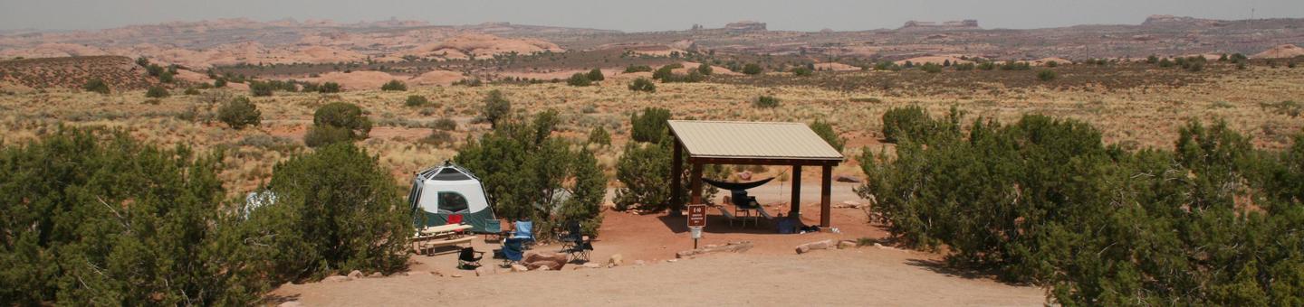
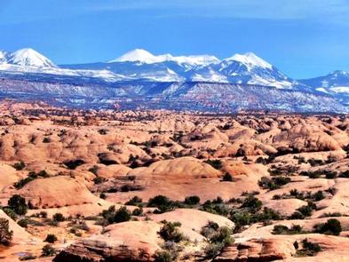
Along with easy access to biking and off-highway vehicle trails, Sand Flats’ campgrounds offer spectacular vistas of sandstone domes, canyons, and mesas in addition to the ever-changing La Sal Mountains as a dramatic back-drop. Visitors are awed by beautiful sunsets, the magic of howling coyotes and a night sky of seemingly unlimited stars.
Recreation
The Sand Flats Recreation Area is home to the Slickrock Bike Trail, a world renowned mountain biking destination. The area is also a premier destination for 4×4 and backcountry motorcycle enthusiasts. There is nearly 40 miles of off-highway vehicle trails to explore within the recreation area.
Facilities
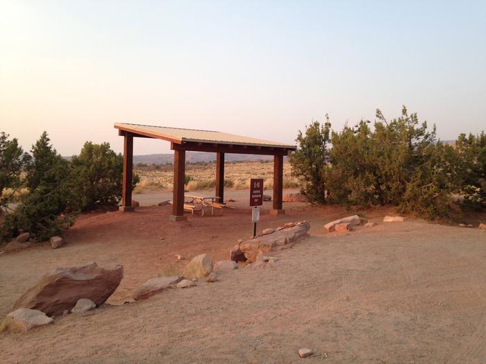
The group campsites are located in the Echo campground, campsites E-1 and E-10. Both campsites accommodate up to 16 people. E-1 has space for six passenger cars, or two RVs, or two to three trucks with camp trailers. E-10 parking is smaller and can accomodate up to 6 pasenger cars, or 1 RV and one to two trucks with camp trailers. Facilities include shade structures, picnic tables and fire rings. There are nearby vault toilet facilities. Campers will need to bring drinking water.
Natural Features
The campground is set among slickrock domes and fins. The sites offer sweeping views of sandstone domes, canyons and mesas against the backdrop of the 13,000 ft. La Sal Mountains. Pinyon and juniper trees offer limited shade.
Nearby Attractions
The sites are located only five miles from downtown Moab, providing convenient access to many bike and off-highway vehicle trails, Arches and Canyonlands National Parks, Dead Horse Point State Park, the Colorado River and the La Sal Mountains.
Charges & Cancellations
If you do not arrive at the group campsite facility by check out time on the day after your scheduled arrival date, which is 11 am, you are considered a no show and your site will be made available to others.