Directions
Take Interstate 10 to exit 121 and travel south to reach the Rainbow Valley Road and Riggs Road. Unmaintained dirt roads extend eastward to the wilderness boundary from here.
Phone
(623) 580-5500
Activities
HIKING, WILDERNESS
Camping Reservations
Reserve your campsite at these camping areas:
Hiking Trails
Looking for nice hiking areas to take a hike? Choose from these scenic hiking trails:
Related Link(s)
Overview
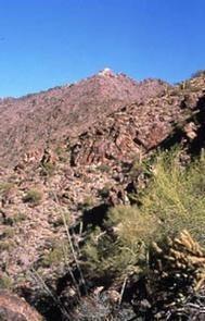
This 14,400-acre wilderness, located just 15 miles southwest of Phoenix, contains one of the most rugged mountain ranges in Arizona. The knife-edged ridgelines, steep slopes and rough rocky canyons provide challenges for hikers, backpackers, climbers and hunters. Butterfly Mountain rises 2,600 feet above the desert plain to an elevation of 4,119 feet in only two miles. The Quartz Peak Trail takes you to the summit of the Sierra Estrella.
The extreme elevation differences have cause diverse plant and animal communities. Plants in lower areas include saguaro and cholla, ocotillo, palverde, and elephant bush. Small protected sites on top of the mountains have shrub-live oak and even juniper. A remnant herd of desert bighorn sheep roam the mountains and Gila monster, desert tortoise, mountain lion, mule deer, coyote, javelina, giant spotted whiptail lizard, golden eagle, prairie falcon and Cooper’s hawk also inhabit the wilderness.
Know Before You Go
In wilderness, you can enjoy challenging recreational activities and extraordinary opportunities for solitude. Please follow the regulations in place for this area, and use Leave No Trace techniques when visiting to ensure protection of its unique natural and experiential qualities.
- Although distinguished as one of the closest wilderness areas to metropolitan Phoenix, four-wheel-drive vehicles are required to approach the wilderness boundary. Primitive dirt roads near the wilderness boundary are extremely sandy or silty, and wash crossings are rugged and deep. Only the western boundary of the wilderness is accessible to the public; elsewhere the area is bounded by the Gila River Indian Reservation.
- Some lands around and within the wilderness are not federally administered. Please respect the property rights of the owners and do not cross or use these lands without their permission.


