


Directions
Accessible early June through October. Located 40 air miles southeast of Sitka, east of Whale Bay, within South Baranof Wilderness Area. Access is by float plane only, and takes 35 minutes from Sitka.
For geographic features surrounding cabin, refer to USGS topographic map Port Alexander C-3.
Phone
907-747-6671
Activities
CAMPING, FISHING, HUNTING
Keywords
DAVD,TONGASS NF – FS
Related Link(s)
Overview
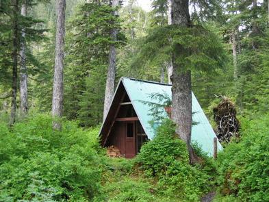
Davidof Lake Cabin is situated in a forested area off Davidof Lake in the Tongass National Forest, approximately 40 air miles southeast of Sitka, Alaska. The A-frame cabin makes a wonderful base for a backcountry experience.
The site is remote and can be accessed by float plane only, weather permitting. Visitors are responsible for their own travel arrangements and safety, and must bring their own amenities.
Recreation
Visitors enjoy picking berries in the surrounding forest, fishing for Dolly Varden from mid-July to September and hunting deer. Some rainbow trout can also be found in the lake. Landscape and wildlife photography opportunities abound.
The 1.2-mile Davidof Lake Trail is located on southwest shore of Davidof Lake and connects to Plotnikof Lake and Cabin. Please note that the trail is not maintained or easy to locate.
For information about fishing and hunting permits and seasons, visit the Alaska Department of Fish and Game website.
Facilities
The rustic 16 by 16-foot A-frame cabin sleeps eight people and contains a sleeping loft that is reached by climbing a vertical ladder. The main level of the cabin is furnished with two double plywood bunks without mattresses. A wood stove for heat, an axe or splitting maul, a table and benches, cooking counter, broom and outhouse toilet are provided.
Visitors must bring sleeping bags and pads, a cooking stove, pots, pans, plates, utensils, food, toilet paper, a lantern, garbage bags, a fire extinguisher, fire starter, rain gear, boots and PFDs.
Water is available from the lake, but must be treated before using. It’s recommended that visitors bring their own water.
A heavy, square-bowed skiff (rowboat) with oars is provided. A long-shaft outboard motor in the 2-10 hp range is highly recommended for use with the skiff, but is not provided. Each person using the skiff should wear a Coast Guard approved personal floating device (PFD). Tie the skiff well up on the shore and pull the plug before leaving so the boat does not fill with rain water.
Click here for more cabin information and maps.
Natural Features
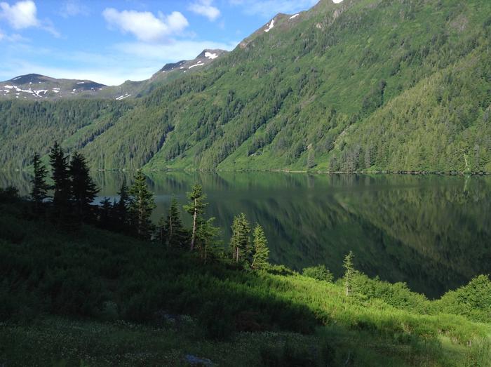
The area offers wilderness solitude and beauty. The cabin is located off the north shore of Davidof Lake, within the South Baranof Wilderness Area, almost one hundred feet inside the edge of the forest with no view of the lake. Davidof Lake is 1.2 miles long, a half-mile wide and sits at an elevation of 650 feet.
Spruce and hemlock forested mountains rise up to a snowfield over 2000 feet in elevation. Blueberry and huckleberry bushes grow on the forest floor around the cabin. Brown bear frequent the area.