


Directions
From Bend, Oregon, go south on Highway 97 for nearly 27 miles to Wickiup Junction. Turn west on Road 43 and continue for 11 miles, then turn west on Forest Service Road 42 for 4.6 miles. Turn south on Forest Service Road 4260 and continue for 3 miles into the campground.
Phone
541-323-1746
Activities
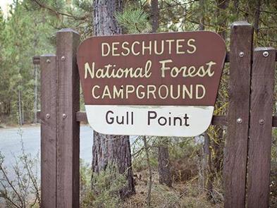
BOATING, CAMPING, FISHING, HIKING, SWIMMING SITE
Keywords
GULP,Gull Point Campground,Gull Point,Gull,Gullpoint,Gull Point Campground (OR)
Related Link(s)
Overview
Located on the shore of Wickiup Reservoir in Deschutes National Forest, Gull Point campground offers visitors easy access to an abundance of recreational activities along the Cascade Lakes National Scenic Byway.
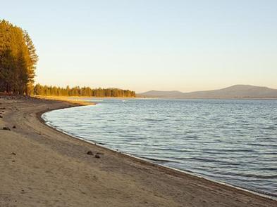
Sites are scattered among a mixed, yet open conifer forest, giving sunshine a chance to filter through. Several sites sit on along the waterfront.
Recreation
Gull Point Campground offers visitors opportunities for hiking, boating, canoeing, swimming and fishing.
The reservoir’s relatively warm water and cooler deep channels generate some of the best fishing in Central Oregon. The area is renowned for its brown trout, often reaching 20 pounds, with normal catches in the 5-to-8 pound range. The reservoir also sustains good numbers of kokanee and coho salmon and decent populations of rainbow trout, brook trout, whitefish and chub.
Facilities
Gull Point campground offers spacious campsites for both tent and RV camping.
Picnic areas, drinking water, vault toilets and a dump station help visitors enjoy the outdoors in a comfortable setting.
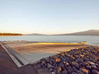
There are also two large day-use areas, with boat launches and fish cleaning stations at each.
Natural Features
The reservoir covers an area on the Deschutes River that was historically used by Native Americans during the fall. Several tribes throughout the area built “wickiups,” shelters made from reeds, grass, or brush, while living in the area.
At full pool, Wickiup is a beautiful, pine-edged reservoir, with some willows and sandy beach areas. At low water, steep soil and gravel banks drop abruptly to the water.
This is one of central Oregon’s best wildlife viewing sites, attracting a variety of nesting and migrating birds. Fantastic nearby peaks, lava flows and forests also provide visitors with a variety of landscapes.
Wetlands, diverse forests, and rocky slopes near the campground provide a necessary habitat for shorebirds, porcupine, deer, bats and the occasional black bear.
Nearby Attractions
Lava Lands Visitor Center in nearby Bend, Oregon, is a great starting point for visitors to learn about the diverse landscape and history of the area through interpretive programs and exhibits.
Visitors can also explore the Lava River Cave, located in the Newberry National Volcanic Monument. At 5,211 feet in length, the northwest section of the cave is the longest continuous lava tube in Oregon.